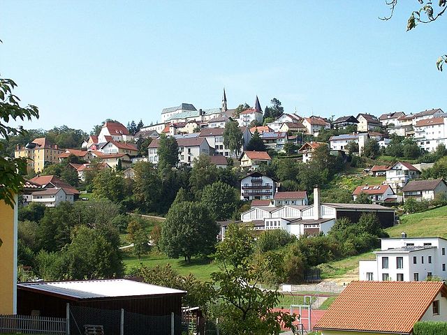
Титлинг (Tittling, Tittling)

 Hiking in Титлинг
Tittling is a small town located in Germany, specifically in the Bavarian region. It's nestled near the border with Austria and is surrounded by scenic nature, making it ideal for hiking enthusiasts. Here are a few highlights about hiking in and around Tittling:
-
Scenic Trails: The area around Tittling offers various hiking trails that range from easy walks to more challenging hikes. Trails often pass through picturesque landscapes, including forests, meadows, and rolling hills.
-
The Bavarian Forest: Tittling is close to the Bavarian Forest National Park, which is one of Germany's oldest national parks. The park offers numerous well-marked trails, including the famous Goldsteig hiking trail, which is a long-distance route known for its breathtaking views and diverse flora and fauna.
-
Local Flora and Fauna: As you hike in the area, you may encounter a rich variety of plant and animal life. The region is home to deer, wild boar, and numerous bird species, making it a great spot for nature lovers and wildlife photography.
-
Cultural Landmarks: While hiking, you can also explore some cultural sites, including quaint villages, historic churches, and monuments. Tittling itself has local charm worth experiencing before or after your hikes.
-
Seasonal Hiking: Depending on the season, hiking experiences can vary. Spring and summer offer lush greenery and blooming wildflowers, while fall provides beautiful foliage. Winter hikes may offer snow-covered trails but require proper gear for safety.
-
Trail Information: It’s essential to have proper maps and trail information before heading out. Local tourist information centers can provide guidelines and updates on trail conditions.
-
Hiking Groups: If you're new to the area or prefer hiking with others, you can look for local hiking clubs or groups that organize hikes, providing a great opportunity to meet fellow hiking enthusiasts.
Before heading out, make sure to check the weather conditions, wear appropriate gear, and stay hydrated. Enjoy your hiking adventure in Tittling!
- Страна:

- Почтовый код: 94104
- Телефонный код: 08504
- Код автомобильного номера: PA
- Координаты: 48° 43' 33" N, 13° 22' 55" E


- GPS треки (wikiloc): [Ссылка]
- Высота над уровнем моря: 540 м m
- Площадь: 20.78 кв.км
- Население: 3860
- Веб сайт: https://www.tittling.de/
- Википедия русская: wiki(ru)
- Википедия английская: wiki(en)
- Википедия национальная: wiki(de)
- Хранилище Wikidata: Wikidata: Q517967
- Катеория в википедии: [Ссылка]
- код Freebase: [/m/02rfqrj]
- код GeoNames: Альт: [2822076]
- код VIAF: Альт: [122656064]
- ID отношения в OpenStreetMap: [958096]
- код GND: Альт: [4060256-4]
- идентификатор местоположения ArchINFORM: [14516]
- код LCNAF: Альт: [nr2002043061]
- место в MusicBrainz: [f5a55eab-eec8-493c-9c90-df7bb5961585]
- WOEID: [699556]
- код Historical Gazetteer: [TITIN1JN68QR]
- Bavarikon ID: [ODB_A00001578]
- идентификатор муниципалитетов в Германии: 09275152
Граничит с регионами:


Нойкирхен-форм-Вальд
Hiking in Нойкирхен-форм-Вальд
Neukirchen vorm Wald, located in Bavaria, Germany, is a charming village that offers appealing hiking opportunities in a picturesque natural setting. The region is characterized by rolling hills, lush forests, and beautiful meadows, making it an ideal destination for hikers of all levels....
- Страна:
- Почтовый код: 94154
- Телефонный код: 08504
- Код автомобильного номера: PA
- Координаты: 48° 41' 0" N, 13° 23' 0" E
- GPS треки (wikiloc): [Ссылка]
- Высота над уровнем моря: 466 м m
- Площадь: 24.3 кв.км
- Население: 2071
- Веб сайт: [Ссылка]


Турмансбанг
Hiking in Турмансбанг
Thurmansbang is a picturesque village located in Bavaria, Germany, surrounded by the beautiful landscape of the Bavarian Forest. It's an excellent destination for hiking enthusiasts, offering a variety of trails that cater to different skill levels and preferences....
- Страна:
- Почтовый код: 94169
- Телефонный код: 08504
- Код автомобильного номера: FRG
- Координаты: 48° 46' 0" N, 13° 19' 0" E
- GPS треки (wikiloc): [Ссылка]
- Высота над уровнем моря: 494 м m
- Площадь: 32.93 кв.км
- Население: 2159
- Веб сайт: [Ссылка]


Зальденбург
Hiking in Зальденбург
Saldenburg, located in Bavaria, Germany, is a charming area that offers a variety of hiking opportunities amidst beautiful natural landscapes. Known for its picturesque countryside, forests, and hills, Saldenburg is an excellent destination for hikers of all levels....
- Страна:
- Почтовый код: 94163
- Телефонный код: 08504
- Код автомобильного номера: FRG
- Координаты: 48° 47' 0" N, 13° 21' 0" E
- GPS треки (wikiloc): [Ссылка]
- Высота над уровнем моря: 532 м m
- Площадь: 28.04 кв.км
- Население: 1982
- Веб сайт: [Ссылка]


Перлесройт
Hiking in Перлесройт
Perlesreut is a charming village located in Bavaria, Germany, close to the border with the Czech Republic. It’s situated in a picturesque region that offers a range of hiking opportunities, making it a great destination for both novice and experienced hikers....
- Страна:
- Почтовый код: 94157
- Телефонный код: 08555
- Код автомобильного номера: FRG
- Координаты: 48° 47' 0" N, 13° 27' 0" E
- GPS треки (wikiloc): [Ссылка]
- Высота над уровнем моря: 542 м m
- Площадь: 29.73 кв.км
- Население: 2686
- Веб сайт: [Ссылка]


Вицмансберг
Hiking in Вицмансберг
Witzmannsberg is a beautiful hiking destination located in Germany, known for its picturesque landscapes and serene environment. Here are some details that may help you plan your hiking trip there:...
- Страна:
- Почтовый код: 94104
- Телефонный код: 08504
- Код автомобильного номера: PA
- Координаты: 48° 43' 0" N, 13° 25' 0" E
- GPS треки (wikiloc): [Ссылка]
- Высота над уровнем моря: 495 м m
- Площадь: 18.74 кв.км
- Население: 1402
- Веб сайт: [Ссылка]

Фюрстенштайн
Hiking in Фюрстенштайн
Fürstenstein, located in Bavaria, Germany, is an attractive destination for hiking enthusiasts. The region is known for its picturesque landscapes, beautiful forests, and rolling hills, making it an ideal spot for both casual walkers and seasoned hikers....
- Страна:
- Почтовый код: 94538
- Телефонный код: 08504
- Код автомобильного номера: PA
- Координаты: 48° 43' 0" N, 13° 20' 0" E
- GPS треки (wikiloc): [Ссылка]
- Высота над уровнем моря: 577 м m
- Площадь: 19.3 кв.км
- Население: 3550
- Веб сайт: [Ссылка]