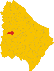
Фара-Сан-Мартино (Fara San Martino, Fara San Martino)
.svg)
- коммуна Италии
 Hiking in Фара-Сан-Мартино
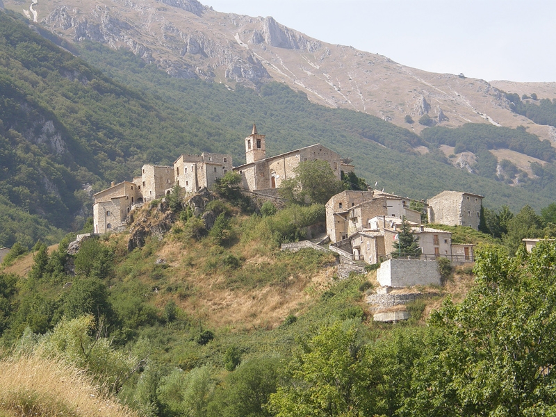
Fara San Martino, located in the Abruzzo region of Italy, is a beautiful destination for hiking enthusiasts. Nestled in the Majella National Park, this area is characterized by stunning natural landscapes, dramatic mountains, and a rich array of flora and fauna. Here are some key points about hiking in Fara San Martino:
Trails and Routes:
-
Majella National Park Trails: The park offers numerous well-marked trails of varying difficulty levels. These trails allow hikers to explore diverse terrains, including rocky paths, lush forests, and panoramic viewpoints.
-
Gole di Fara San Martino: This gorge is particularly popular and offers challenging hikes with breathtaking views of the surrounding cliffs. The trail follows the river and takes you through fascinating geological formations.
-
Cima di Terratta: For more experienced hikers, the ascent to Cima di Terratta provides a rewarding challenge with spectacular views from the summit.
-
Sentiero del Tratturo: This scenic route passes through ancient herding paths and leads through beautiful landscapes, perfect for those looking for more gentle walks combined with cultural history.
Wildlife and Flora:
Hikers may encounter a variety of wildlife, including deer, foxes, and numerous bird species. The area's rich biodiversity makes it a wonderful spot for nature lovers. The flora includes a mix of alpine plants and forest trees, providing a lush environment that changes with the seasons.
Best Time to Hike:
The best times for hiking in Fara San Martino are during the spring and early autumn months (April to June and September to October). During these seasons, the weather is generally mild, and the landscapes are vibrant with blooming flowers or autumn colors. Summer can be warm, while winter may bring snow to the higher elevations.
Essential Tips:
- Gear: Make sure to wear appropriate hiking boots and carry essential gear such as water, snacks, a first aid kit, and a map or GPS.
- Safety: Always inform someone of your hiking plans, especially if you are heading into less traveled areas. Be aware of the weather conditions and stay hydrated.
- Respect Nature: Follow the Leave No Trace principles to protect the pristine environment of Majella National Park.
Local Culture:
Fara San Martino is also known for its pasta production, particularly the famous "maccheroni chitori." After a day of hiking, enjoy a meal in the local restaurants to experience the regional cuisine.
Overall, Fara San Martino offers a variety of hiking experiences suitable for all levels, all amidst the stunning backdrop of the Abruzzo mountains. Whether you're looking for a leisurely stroll or a challenging climb, this area is sure to impress with its natural beauty.
- Страна:

- Почтовый код: 66015
- Телефонный код: 0872
- Код автомобильного номера: CH
- Координаты: 42° 5' 28" N, 14° 12' 22" E


- GPS треки (wikiloc): [Ссылка]
- Высота над уровнем моря: 440 м m
- Площадь: 44.69 кв.км
- Население: 1379
- Веб сайт: http://www.comune.faranovarese.no.it
- Википедия русская: wiki(ru)
- Википедия английская: wiki(en)
- Википедия национальная: wiki(it)
- Хранилище Wikidata: Wikidata: Q51219
- Катеория в википедии: [Ссылка]
- код Freebase: [/m/0fg2_7]
- код GeoNames: Альт: [6537478]
- код VIAF: Альт: [233950645]
- ID отношения в OpenStreetMap: [41766]
- WOEID: [715293]
- UN/LOCODE: [ITZJB]
- код ISTAT: 069031
- кадастровый код Италии: D495
Граничит с регионами:

Пачентро
- коммуна Италии
Hiking in Пачентро
Pacentro, located in the Abruzzo region of Italy, is a charming hilltop village known for its stunning views, ancient architecture, and access to beautiful natural landscapes. Hiking in and around Pacentro offers a unique experience, blending culture, history, and nature....
- Страна:
- Почтовый код: 67030
- Телефонный код: 0864
- Код автомобильного номера: AQ
- Координаты: 42° 3' 2" N, 13° 59' 29" E
- GPS треки (wikiloc): [Ссылка]
- Высота над уровнем моря: 653 м m
- Площадь: 72.59 кв.км
- Население: 1140
- Веб сайт: [Ссылка]


Чивителла-Мессер-Раймондо
- коммуна Италии
Hiking in Чивителла-Мессер-Раймондо
Civitella Messer Raimondo is a beautiful village located in the Abruzzo region of Italy, surrounded by scenic landscapes, rolling hills, and rugged mountains. Hiking in this area offers a variety of trails suitable for different experience levels, making it a great destination for outdoor enthusiasts....
- Страна:
- Почтовый код: 66010
- Телефонный код: 0872
- Код автомобильного номера: CH
- Координаты: 42° 5' 0" N, 14° 13' 0" E
- GPS треки (wikiloc): [Ссылка]
- Высота над уровнем моря: 613 м m
- Площадь: 12.72 кв.км
- Население: 818
- Веб сайт: [Ссылка]


Лама-дей-Пелиньи
- коммуна Италии
Hiking in Лама-дей-Пелиньи
Lama dei Peligni is a picturesque village located in the mountains of the Abruzzo region in Italy. It's an excellent destination for hikers due to its stunning natural landscapes, varied terrain, and beautiful views of the surrounding Apennine mountains. Here are some highlights of hiking in this area:...
- Страна:
- Почтовый код: 66010
- Телефонный код: 0872
- Код автомобильного номера: CH
- Координаты: 42° 3' 0" N, 14° 11' 0" E
- GPS треки (wikiloc): [Ссылка]
- Высота над уровнем моря: 669 м m
- Площадь: 31.37 кв.км
- Население: 1200
- Веб сайт: [Ссылка]

Паломбаро
- коммуна Италии
Hiking in Паломбаро
Palombaro is a charming village located in the Abruzzo region of Italy. Nestled in the Apennine Mountains, it offers a variety of hiking opportunities characterized by beautiful landscapes, dense forests, and picturesque views. Here are some highlights and tips for hiking in and around Palombaro:...
- Страна:
- Почтовый код: 66010
- Телефонный код: 0871
- Код автомобильного номера: CH
- Координаты: 42° 7' 24" N, 14° 13' 48" E
- GPS треки (wikiloc): [Ссылка]
- Высота над уровнем моря: 536 м m
- Площадь: 17.19 кв.км
- Население: 1001
- Веб сайт: [Ссылка]


Пеннапьедимонте
- коммуна Италии
Hiking in Пеннапьедимонте
Pennapiedimonte is a charming village located in the Abruzzo region of Italy, known for its stunning natural landscapes and rich biodiversity. The surrounding area offers various hiking opportunities that cater to different skill levels, making it a fantastic destination for both novice and experienced hikers....
- Страна:
- Почтовый код: 66010
- Телефонный код: 0871
- Код автомобильного номера: CH
- Координаты: 42° 9' 8" N, 14° 11' 41" E
- GPS треки (wikiloc): [Ссылка]
- Высота над уровнем моря: 669 м m
- Площадь: 47.03 кв.км
- Население: 445
- Веб сайт: [Ссылка]


Караманико-Терме
- коммуна Италии
Hiking in Караманико-Терме
Caramanico Terme is a charming village located in the Abruzzo region of Italy, renowned for its thermal springs and stunning natural beauty. It’s nestled in the Majella National Park, making it an excellent destination for hiking enthusiasts. Here are some key points about hiking in the area:...
- Страна:
- Почтовый код: 65023
- Телефонный код: 085
- Код автомобильного номера: PE
- Координаты: 42° 9' 0" N, 14° 1' 0" E
- GPS треки (wikiloc): [Ссылка]
- Высота над уровнем моря: 650 м m
- Площадь: 84.99 кв.км
- Население: 1872
- Веб сайт: [Ссылка]

Сант'Эуфемия-а-Маелла
- коммуна Италии
Hiking in Сант'Эуфемия-а-Маелла
Sant'Eufemia a Maiella is a beautiful village located in the Abruzzo region of Italy, surrounded by the stunning landscapes of the Maiella National Park. It's an excellent destination for hiking enthusiasts, offering a variety of trails that cater to different skill levels. Here are some key points to consider when hiking in this area:...
- Страна:
- Почтовый код: 65020
- Телефонный код: 085
- Код автомобильного номера: PE
- Координаты: 42° 7' 0" N, 14° 1' 0" E
- GPS треки (wikiloc): [Ссылка]
- Высота над уровнем моря: 878 м m
- Площадь: 40.42 кв.км
- Население: 263
- Веб сайт: [Ссылка]