
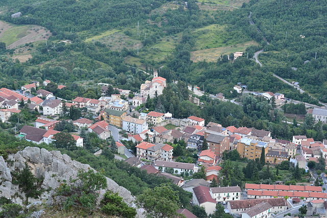
Лама-дей-Пелиньи (Lama dei Peligni, Lama dei Peligni)
.svg)
- коммуна Италии
 Hiking in Лама-дей-Пелиньи
Lama dei Peligni is a picturesque village located in the mountains of the Abruzzo region in Italy. It's an excellent destination for hikers due to its stunning natural landscapes, varied terrain, and beautiful views of the surrounding Apennine mountains. Here are some highlights of hiking in this area:
Trails and Routes
-
Gole di Fara Sancti Angeli: This is a scenic gorge offering several hiking trails that take you through lush vegetation and alongside the river. The views of the rock formations and wildlife make it a popular choice.
-
Majella National Park: The park surrounding Lama dei Peligni is home to various hiking trails ranging from easy walks to more challenging treks. You'll find paths leading to viewpoints, ancient hermitages, and even caves. The park is rich in biodiversity and offers opportunities for wildlife spotting.
-
Hermitage of San Bartolomeo in Legio: A moderate hike leads to this historic hermitage built into the cliffs. The trail provides stunning views and is a great spot for both history and nature lovers.
-
Monte Amaro: For those seeking a more strenuous hike, Monte Amaro, the second-highest peak in the Apennines, offers challenging routes with incredible panoramic views. It’s advisable to check the trail conditions and weather before attempting this hike.
Best Time to Hike
The best times for hiking in Lama dei Peligni are during the spring (April to June) and fall (September to October) when temperatures are milder, and the landscape is particularly beautiful with wildflowers in bloom or autumn foliage.
Preparation and Safety
- Gear: Good hiking shoes, weather-appropriate clothing, and a sturdy backpack with water and snacks are essential.
- Map & Navigation: Familiarize yourself with trail maps beforehand. Many trails are marked, but a map can help navigate less obvious paths.
- Wildlife Cautions: While the area is safe for hikers, it’s wise to be aware of local wildlife and not to provoke any animals you encounter.
Cultural Aspects
Hiking in this area also offers the chance to experience local culture, including the villages’ architecture, cuisine, and traditions. After a long day of hiking, try local delicacies such as arrosticini (grilled skewers) and enjoy the hospitality of the locals.
Conclusion
Lama dei Peligni is an exceptional destination for hiking enthusiasts, combining natural beauty with historical significance. Whether you’re a seasoned hiker or a casual walker, the region offers something for everyone. Always ensure to follow local guidelines and respect the environment during your hiking adventures!
- Страна:

- Почтовый код: 66010
- Телефонный код: 0872
- Код автомобильного номера: CH
- Координаты: 42° 3' 0" N, 14° 11' 0" E


- GPS треки (wikiloc): [Ссылка]
- Высота над уровнем моря: 669 м m
- Площадь: 31.37 кв.км
- Население: 1200
- Веб сайт: http://www.comunelamadeipeligni.it
- Википедия русская: wiki(ru)
- Википедия английская: wiki(en)
- Википедия национальная: wiki(it)
- Хранилище Wikidata: Wikidata: Q51243
- Катеория в википедии: [Ссылка]
- код Freebase: [/m/0fg371]
- код GeoNames: Альт: [6538881]
- код VIAF: Альт: [243548408]
- ID отношения в OpenStreetMap: [41727]
- код ISTAT: 069045
- кадастровый код Италии: E424
Граничит с регионами:

Пачентро
- коммуна Италии
Hiking in Пачентро
Pacentro, located in the Abruzzo region of Italy, is a charming hilltop village known for its stunning views, ancient architecture, and access to beautiful natural landscapes. Hiking in and around Pacentro offers a unique experience, blending culture, history, and nature....
- Страна:
- Почтовый код: 67030
- Телефонный код: 0864
- Код автомобильного номера: AQ
- Координаты: 42° 3' 2" N, 13° 59' 29" E
- GPS треки (wikiloc): [Ссылка]
- Высота над уровнем моря: 653 м m
- Площадь: 72.59 кв.км
- Население: 1140
- Веб сайт: [Ссылка]


Чивителла-Мессер-Раймондо
- коммуна Италии
Hiking in Чивителла-Мессер-Раймондо
Civitella Messer Raimondo is a beautiful village located in the Abruzzo region of Italy, surrounded by scenic landscapes, rolling hills, and rugged mountains. Hiking in this area offers a variety of trails suitable for different experience levels, making it a great destination for outdoor enthusiasts....
- Страна:
- Почтовый код: 66010
- Телефонный код: 0872
- Код автомобильного номера: CH
- Координаты: 42° 5' 0" N, 14° 13' 0" E
- GPS треки (wikiloc): [Ссылка]
- Высота над уровнем моря: 613 м m
- Площадь: 12.72 кв.км
- Население: 818
- Веб сайт: [Ссылка]
Колледимачине
- коммуна Италии
Hiking in Колледимачине
Colledimacine, located in the Abruzzo region of Italy, is a fantastic destination for hiking enthusiasts. Nestled within the Gran Sasso e Monti della Laga National Park, it offers breathtaking landscapes, diverse ecosystems, and a variety of hiking trails suitable for different skill levels....
- Страна:
- Почтовый код: 66010
- Телефонный код: 0872
- Код автомобильного номера: CH
- Координаты: 42° 0' 0" N, 14° 12' 0" E
- GPS треки (wikiloc): [Ссылка]
- Высота над уровнем моря: 770 м m
- Площадь: 11.3 кв.км
- Население: 188
- Веб сайт: [Ссылка]


Фара-Сан-Мартино
- коммуна Италии
Hiking in Фара-Сан-Мартино
Fara San Martino, located in the Abruzzo region of Italy, is a beautiful destination for hiking enthusiasts. Nestled in the Majella National Park, this area is characterized by stunning natural landscapes, dramatic mountains, and a rich array of flora and fauna. Here are some key points about hiking in Fara San Martino:...
- Страна:
- Почтовый код: 66015
- Телефонный код: 0872
- Код автомобильного номера: CH
- Координаты: 42° 5' 28" N, 14° 12' 22" E
- GPS треки (wikiloc): [Ссылка]
- Высота над уровнем моря: 440 м m
- Площадь: 44.69 кв.км
- Население: 1379
- Веб сайт: [Ссылка]


Джессопалена
- коммуна Италии
Hiking in Джессопалена
Gessopalena is a charming village located in the Abruzzo region of Italy, known for its stunning natural landscapes and outdoor activities, including hiking. The area offers a range of trails that cater to different skill levels, making it an excellent destination for both novice and experienced hikers....
- Страна:
- Почтовый код: 66010
- Телефонный код: 0872
- Код автомобильного номера: CH
- Координаты: 42° 3' 0" N, 14° 16' 0" E
- GPS треки (wikiloc): [Ссылка]
- Высота над уровнем моря: 654 м m
- Площадь: 31.47 кв.км
- Население: 1360
- Веб сайт: [Ссылка]

Таранта-Пелинья
- коммуна Италии
Hiking in Таранта-Пелинья
Taranta Peligna is a quaint village located in the Abruzzo region of Italy, surrounded by stunning natural landscapes that make it a great destination for hiking enthusiasts. The area boasts a mix of rolling hills, mountainous terrain, and picturesque views, making it ideal for various hiking experiences....
- Страна:
- Почтовый код: 66018
- Телефонный код: 0872
- Код автомобильного номера: CH
- Координаты: 42° 1' 0" N, 14° 10' 0" E
- GPS треки (wikiloc): [Ссылка]
- Высота над уровнем моря: 460 м m
- Площадь: 21.9 кв.км
- Население: 353
- Веб сайт: [Ссылка]


Торричелла-Пелинья
- коммуна Италии
Hiking in Торричелла-Пелинья
Torricella Peligna is a picturesque village located in the Abruzzo region of Italy. Nestled in the Apennine Mountains, it is surrounded by stunning natural landscapes, making it an excellent destination for hiking enthusiasts. Here are some highlights and tips for hiking in Torricella Peligna:...
- Страна:
- Почтовый код: 66019
- Телефонный код: 0872
- Код автомобильного номера: CH
- Координаты: 42° 1' 0" N, 14° 16' 0" E
- GPS треки (wikiloc): [Ссылка]
- Высота над уровнем моря: 910 м m
- Площадь: 36.11 кв.км
- Население: 1292
- Веб сайт: [Ссылка]