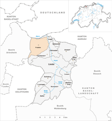
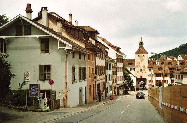
Френкендорф (Frenkendorf, Frenkendorf)

 Hiking in Френкендорф
Frenkendorf is a charming municipality located in the Basel-Landschaft district of Switzerland, surrounded by scenic landscapes and rolling hills. Hiking in Frenkendorf offers a variety of trails that cater to different skill levels, making it a great destination for both novice and experienced hikers.
Trail Highlights:
-
Local Trails: There are several marked paths starting in or near Frenkendorf, which lead into the surrounding countryside. These trails often feature beautiful views of the nearby Jura Mountains and the Rhine Valley.
-
The "Blumenweg": This is a popular local trail that showcases the region’s flora and fauna, making it a delightful option during the spring and summer months when wildflowers are in bloom.
-
Wine Trails: Given the proximity to vineyards in the area, there are trails that allow hikers to explore local wine routes, offering the chance to enjoy tastings and experience the winemaking process.
-
Jura Mountain Trails: Just a short drive away, the Jura mountains provide extensive hiking opportunities with trails varying from easy walks to more challenging hikes, including stunning panoramic views.
Considerations:
-
Seasonal Conditions: Depending on the season, weather can vary significantly, so it's important to check conditions before setting out. Spring and summer generally provide the best hiking weather, but autumn offers beautiful foliage and cooler temperatures.
-
Gear: Ensure you have suitable hiking gear, including good walking shoes, a backpack with water, snacks, and a map or GPS device for navigation.
-
Local Regulations: Always try to stay on marked trails and respect local wildlife. Consider checking in with local tourist information for any specific regulations or recommendations.
Accessibility:
Frenkendorf is well-connected by public transport, making it easily accessible for those traveling from larger cities like Basel. Various transportation options are available, including trains and buses.
Enjoyment:
Whether you're seeking a leisurely stroll through vineyards or a more challenging hike in the nearby Jura Mountains, Frenkendorf and its surrounding areas provide ample opportunities for enjoying the natural beauty and tranquility of the Swiss outdoors. Don't forget to take your camera, as the picturesque views are definitely worth capturing!
- Страна:

- Почтовый код: 4402
- Телефонный код: 061
- Код автомобильного номера: BL
- Координаты: 47° 30' 3" N, 7° 41' 49" E


- GPS треки (wikiloc): [Ссылка]
- Высота над уровнем моря: 412 м m
- Площадь: 4.58 кв.км
- Население: 6471
- Веб сайт: http://www.frenkendorf.ch
- Википедия русская: wiki(ru)
- Википедия английская: wiki(en)
- Википедия национальная: wiki(de)
- Хранилище Wikidata: Wikidata: Q66593
- Катеория в википедии: [Ссылка]
- код Freebase: [/m/0g6f5k]
- код GeoNames: Альт: [7285868]
- код VIAF: Альт: [144246190]
- ID отношения в OpenStreetMap: [1683647]
- место в MusicBrainz: [19e9af0f-6187-4967-9f80-b24de6ae74db]
- идентификатор HDS: [1206]
- код швейцарского муниципалитета: [2824]
- код Цифрового атласа Римской империи: [38727]
Граничит с регионами:

Праттельн
Hiking in Праттельн
Pratteln, located in the Basel-Landschaft region of Switzerland, offers a variety of hiking opportunities that cater to different skill levels. The area is rich in natural beauty, featuring lush forests, rolling hills, and panoramic views of the surrounding landscape, including the nearby Jura Mountains....
- Страна:
- Почтовый код: 4133
- Телефонный код: 061
- Код автомобильного номера: BL
- Координаты: 47° 31' 7" N, 7° 41' 34" E
- GPS треки (wikiloc): [Ссылка]
- Высота над уровнем моря: 292 м m
- Площадь: 10.70 кв.км
- Население: 16388
- Веб сайт: [Ссылка]


Муттенц
Hiking in Муттенц
Muttenz is a charming municipality located near Basel in Switzerland, surrounded by lush landscapes and diverse trails, making it a great destination for hiking enthusiasts. Here are some key aspects of hiking in Muttenz:...
- Страна:
- Почтовый код: 4132
- Телефонный код: 061
- Код автомобильного номера: BL
- Координаты: 47° 31' 29" N, 7° 38' 57" E
- GPS треки (wikiloc): [Ссылка]
- Высота над уровнем моря: 287 м m
- Площадь: 16.64 кв.км
- Население: 17805
- Веб сайт: [Ссылка]
Фюллинсдорф
Hiking in Фюллинсдорф
Füllinsdorf is a charming village located near Basel in the canton of Basel-Landschaft, Switzerland. While the village itself might not have extensive hiking trails, its proximity to the surrounding areas offers various hiking opportunities....
- Страна:
- Почтовый код: 4414
- Телефонный код: 061
- Код автомобильного номера: BL
- Координаты: 47° 30' 39" N, 7° 43' 55" E
- GPS треки (wikiloc): [Ссылка]
- Высота над уровнем моря: 388 м m
- Площадь: 4.62 кв.км
- Население: 4472
- Веб сайт: [Ссылка]


Гемпен
Hiking in Гемпен
Gempen is a beautiful area located in Switzerland, just outside of Basel, offering excellent hiking opportunities with stunning views of the surrounding landscape, including the city of Basel and the Rhine River. The Gempen plateau is characterized by its rolling hills, forests, and open fields, making it an ideal destination for both casual walkers and more experienced hikers....
- Страна:
- Почтовый код: 4145
- Телефонный код: 061
- Код автомобильного номера: SO
- Координаты: 47° 28' 42" N, 7° 39' 33" E
- GPS треки (wikiloc): [Ссылка]
- Высота над уровнем моря: 714 м m
- Площадь: 5.96 кв.км
- Население: 880
- Веб сайт: [Ссылка]

Листаль
Hiking in Листаль
Liestal, located in the Basel-Landschaft region of Switzerland, is a beautiful area that offers a variety of hiking opportunities suited for all levels of hikers. Here are some highlights about hiking in and around Liestal:...
- Страна:
- Почтовый код: 4410
- Телефонный код: 061
- Код автомобильного номера: BL
- Координаты: 47° 29' 2" N, 7° 44' 6" E
- GPS треки (wikiloc): [Ссылка]
- Высота над уровнем моря: 342 м m
- Площадь: 18.19 кв.км
- Население: 14269
- Веб сайт: [Ссылка]


Нуглар-Санкт-Панталеон
Hiking in Нуглар-Санкт-Панталеон
Nuglar-St. Pantaleon is a serene area in the Swiss region of Basel-Landschaft that offers beautiful landscapes and a variety of hiking trails suitable for different skill levels. Here are some important details to consider if you're planning a hike in this area:...
- Страна:
- Почтовый код: 4412
- Телефонный код: 061
- Код автомобильного номера: SO
- Координаты: 47° 28' 19" N, 7° 41' 35" E
- GPS треки (wikiloc): [Ссылка]
- Высота над уровнем моря: 488 м m
- Площадь: 6.34 кв.км
- Население: 1486
- Веб сайт: [Ссылка]