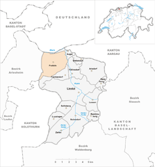
Гемпен (Gempen, Gempen)

 Hiking in Гемпен
Gempen is a beautiful area located in Switzerland, just outside of Basel, offering excellent hiking opportunities with stunning views of the surrounding landscape, including the city of Basel and the Rhine River. The Gempen plateau is characterized by its rolling hills, forests, and open fields, making it an ideal destination for both casual walkers and more experienced hikers.
Hiking Trails
- Gempen Trail: A popular trail that offers panoramic views of the Rhine Valley. It’s suitable for all skill levels and is well-marked.
- Sonniger Rundweg: This sunny circular trail takes you through scenic meadows and woodlands, providing a lovely experience for families and beginner hikers.
- Gempenberg: A more challenging hike that leads up to the Gempenberg, which rewards hikers with breathtaking views of the surrounding region. The trail may include steeper sections and requires a moderate level of fitness.
Points of Interest
- Viewpoints: There are various lookout points along the trails where hikers can stop to enjoy the vistas.
- Historical Sites: The area has historical significance with remnants of ancient fortifications and churches, often adding an enriching aspect to your hike.
- Flora and Fauna: Gempen is also a great place to observe local wildlife and diverse plant species, especially during the spring and summer months.
Practical Information
- Accessibility: Gempen is accessible by public transport from Basel, with frequent connections. There are also parking facilities available for those driving.
- Best Time to Visit: The best time for hiking in Gempen is from late spring to early autumn when the weather is mild and the trails are in good condition.
- Safety: Always check the weather forecast before heading out, and it's advisable to carry enough water, snacks, and a map or GPS device.
Make sure to follow local regulations and respect the natural environment during your hike. Happy hiking in Gempen!
- Страна:

- Почтовый код: 4145
- Телефонный код: 061
- Код автомобильного номера: SO
- Координаты: 47° 28' 42" N, 7° 39' 33" E


- GPS треки (wikiloc): [Ссылка]
- Высота над уровнем моря: 714 м m
- Площадь: 5.96 кв.км
- Население: 880
- Веб сайт: http://www.gempen.ch
- Википедия русская: wiki(ru)
- Википедия английская: wiki(en)
- Википедия национальная: wiki(de)
- Хранилище Wikidata: Wikidata: Q66542
- Катеория в википедии: [Ссылка]
- код Freebase: [/m/0g4p93]
- код GeoNames: Альт: [7285899]
- код VIAF: Альт: [245392023]
- ID отношения в OpenStreetMap: [1683507]
- идентификатор HDS: [1099]
- код швейцарского муниципалитета: [2474]
Граничит с регионами:

Праттельн
Hiking in Праттельн
Pratteln, located in the Basel-Landschaft region of Switzerland, offers a variety of hiking opportunities that cater to different skill levels. The area is rich in natural beauty, featuring lush forests, rolling hills, and panoramic views of the surrounding landscape, including the nearby Jura Mountains....
- Страна:
- Почтовый код: 4133
- Телефонный код: 061
- Код автомобильного номера: BL
- Координаты: 47° 31' 7" N, 7° 41' 34" E
- GPS треки (wikiloc): [Ссылка]
- Высота над уровнем моря: 292 м m
- Площадь: 10.70 кв.км
- Население: 16388
- Веб сайт: [Ссылка]

Френкендорф
Hiking in Френкендорф
Frenkendorf is a charming municipality located in the Basel-Landschaft district of Switzerland, surrounded by scenic landscapes and rolling hills. Hiking in Frenkendorf offers a variety of trails that cater to different skill levels, making it a great destination for both novice and experienced hikers....
- Страна:
- Почтовый код: 4402
- Телефонный код: 061
- Код автомобильного номера: BL
- Координаты: 47° 30' 3" N, 7° 41' 49" E
- GPS треки (wikiloc): [Ссылка]
- Высота над уровнем моря: 412 м m
- Площадь: 4.58 кв.км
- Население: 6471
- Веб сайт: [Ссылка]