Фройденштадт (Freudenstadt, Landkreis Freudenstadt)

 Hiking in Фройденштадт
Freudenstadt, located in the Black Forest region of Germany, offers a wealth of hiking opportunities for outdoor enthusiasts. The district is known for its picturesque landscapes, dense forests, and charming villages, making it an ideal destination for hikers of all levels.
Key Hiking Highlights
-
Scenic Trails: The area features a variety of trails, from easy walks through the woods to challenging mountain hikes. Many trails are well-marked and maintained, showcasing breathtaking views, waterfalls, and diverse flora and fauna.
-
Baiersbronn: This nearby town is famous for its gourmet restaurants but is also a hiker's paradise. The extensive network of trails in and around Baiersbronn includes panoramic paths and routes suitable for families.
-
National Park Schwarzwald: Just a short drive from Freudenstadt, this national park offers stunning natural scenery and numerous hiking trails showcasing the majestic Black Forest landscape.
-
Panoramaweg Freudenstadt: A popular circular trail that allows hikers to enjoy the stunning vistas of the surrounding area. It takes you through various terrains, including forests and meadows.
-
Hiking Trails for All Levels: There are routes suitable for beginners, including flat, well-marked trails, as well as more challenging options for experienced hikers looking to explore the rugged terrain.
-
Wildlife and Nature: Hikers can enjoy the rich biodiversity of the Black Forest region, where you may encounter deer, foxes, and a variety of bird species. The forest is also home to beautiful wildflowers, especially in spring and summer.
-
Local Culture and Historic Sites: As you hike, take the time to explore charming villages and historical sites along the way. You can witness traditional Black Forest architecture and even sample local cuisine in small eateries.
Tips for Hiking in Freudenstadt
- Check Weather Conditions: The weather can change quickly in the Black Forest. Be prepared with appropriate clothing and gear.
- Hydrate and Snack: Always carry sufficient water and snacks, especially on longer hikes.
- Trail Maps and Apps: Use local maps or hiking apps for navigation, as some trails may not be marked as clearly as others.
- Respect Nature: Follow "Leave No Trace" principles to preserve the area’s natural beauty.
Conclusion
Hiking in Freudenstadt offers an enriching experience through one of Germany's most beautiful and diverse landscapes. Whether you're a seasoned hiker or just looking for a leisurely stroll, the region has something to offer everyone. Enjoy your adventure!
- Страна:

- Столица: Фройденштадт
- Код автомобильного номера: HOR; FDS
- Координаты: 48° 30' 0" N, 8° 25' 12" E


- GPS треки (wikiloc): [Ссылка]
- Высота над уровнем моря: 645 м m
- Площадь: 870.68 кв.км
- Население: 115055
- Веб сайт: http://www.landkreis-freudenstadt.de/
- Википедия русская: wiki(ru)
- Википедия английская: wiki(en)
- Википедия национальная: wiki(de)
- Хранилище Wikidata: Wikidata: Q8189
- Катеория в википедии: [Ссылка]
- Карты в википедии: [Ссылка]
- код Freebase: [/m/01j5d7]
- код GeoNames: Альт: [2924895]
- код VIAF: Альт: [129111970]
- ID отношения в OpenStreetMap: [62354]
- код GND: Альт: [4018469-9]
- идентификатор местоположения ArchINFORM: [2419]
- код LCNAF: Альт: [n88130244]
- код темы Quora: [Freudenstadt]
- код TGN: [7191041]
- код NUTS: [DE12C]
- код района Германии: 08237
Включает регионы:

объединение коммун Фройденштадт
Hiking in объединение коммун Фройденштадт
Freudenstadt, located in the northern part of the Black Forest region of Germany, offers a beautiful setting for hiking enthusiasts. It's particularly known for its vast forests, stunning landscapes, and well-marked trails that cater to various skill levels. Here's some information to help guide your hiking experience in the Freudenstadt area:...
- Страна:


Эмпфинген
Hiking in Эмпфинген
Empfingen is a small village located in the state of Baden-Württemberg, Germany. It's surrounded by beautiful landscapes that offer various hiking opportunities, suitable for all levels. Here are some key points about hiking in and around Empfingen:...
- Страна:
- Почтовый код: 72186
- Телефонный код: 07485
- Код автомобильного номера: FDS
- Координаты: 48° 23' 33" N, 8° 42' 38" E
- GPS треки (wikiloc): [Ссылка]
- Высота над уровнем моря: 494 м m
- Площадь: 18.29 кв.км
- Население: 4026
- Веб сайт: [Ссылка]

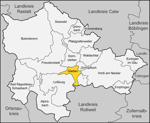
Глаттен
Hiking in Глаттен
Glatten is a charming municipality located in the Black Forest region of Germany, known for its picturesque landscapes, dense forests, and serene hiking trails. Hiking in Glatten offers a variety of routes that cater to all levels of experience, making it an attractive destination for both casual walkers and seasoned hikers....
- Страна:
- Почтовый код: 72293
- Телефонный код: 07443
- Код автомобильного номера: FDS
- Координаты: 48° 26' 0" N, 8° 31' 0" E
- GPS треки (wikiloc): [Ссылка]
- Высота над уровнем моря: 506 м m
- Площадь: 15.52 кв.км
- Население: 2323
- Веб сайт: [Ссылка]
Вёрнерсберг
Hiking in Вёрнерсберг
Wörnersberg, located in the Black Forest region of Germany, is a fantastic destination for hiking enthusiasts. This area features a variety of trails that cater to different experience levels, from gentle walks suitable for families to more challenging climbs for seasoned hikers....
- Страна:
- Почтовый код: 72299
- Телефонный код: 07453
- Код автомобильного номера: FDS
- Координаты: 48° 33' 44" N, 8° 33' 52" E
- GPS треки (wikiloc): [Ссылка]
- Высота над уровнем моря: 618 м m
- Площадь: 3.48 кв.км
- Население: 237
Грёмбах
Hiking in Грёмбах
Grömbach is a charming village located in the Black Forest region of Germany. Hiking in this area offers stunning natural beauty, diverse landscapes, and well-marked trails suitable for various skill levels. Here are some key highlights about hiking in and around Grömbach:...
- Страна:
- Почтовый код: 72297; 72294
- Телефонный код: 07453
- Код автомобильного номера: FDS
- Координаты: 48° 34' 18" N, 8° 32' 47" E
- GPS треки (wikiloc): [Ссылка]
- Высота над уровнем моря: 634 м m
- Площадь: 12.18 кв.км
- Население: 619
- Веб сайт: [Ссылка]


Шопфлох
Hiking in Шопфлох
Schopfloch is a small town located in the beautiful region of the Swabian Jura in Germany. It is ideal for hiking enthusiasts, offering a variety of scenic trails that showcase the natural beauty of the area. Here are some highlights to consider when planning your hiking trip in Schopfloch:...
- Страна:
- Почтовый код: 72296
- Телефонный код: 07443
- Код автомобильного номера: FDS
- Координаты: 48° 27' 16" N, 8° 33' 5" E
- GPS треки (wikiloc): [Ссылка]
- Высота над уровнем моря: 667 м m
- Площадь: 17.04 кв.км
- Население: 2580
- Веб сайт: [Ссылка]


Вальдахталь
Hiking in Вальдахталь
Waldachtal, located in the Black Forest region of Germany, offers a variety of hiking trails that showcase the area’s natural beauty, charming landscapes, and rich biodiversity. Here are some key highlights and tips for hiking in Waldachtal:...
- Страна:
- Почтовый код: 72178
- Телефонный код: 07486; 07445; 07443
- Код автомобильного номера: FDS
- Координаты: 48° 29' 22" N, 8° 33' 53" E
- GPS треки (wikiloc): [Ссылка]
- Высота над уровнем моря: 599 м m
- Площадь: 29.87 кв.км
- Население: 6009
- Веб сайт: [Ссылка]


Байрсброн
Hiking in Байрсброн
Baiersbronn is a beautiful town located in the Black Forest region of Germany, renowned for its stunning natural landscapes and hiking opportunities. It offers a variety of trails suitable for all skill levels, making it an ideal destination for both novice and experienced hikers....
- Страна:
- Почтовый код: 72270
- Телефонный код: 07449; 07447; 07442
- Код автомобильного номера: FDS
- Координаты: 48° 30' 21" N, 8° 22' 16" E
- GPS треки (wikiloc): [Ссылка]
- Высота над уровнем моря: 584 м m
- Площадь: 189.69 кв.км
- Население: 14500
- Веб сайт: [Ссылка]


Лосбург
Hiking in Лосбург
Loßburg is a picturesque town located in the Black Forest region of Germany, known for its beautiful landscapes, dense forests, and excellent hiking trails. Here are some key points to consider when hiking in Loßburg:...
- Страна:
- Почтовый код: 72290
- Телефонный код: 07446
- Код автомобильного номера: FDS
- Координаты: 48° 24' 40" N, 8° 27' 5" E
- GPS треки (wikiloc): [Ссылка]
- Высота над уровнем моря: 666 м m
- Площадь: 79.26 кв.км
- Население: 7406
- Веб сайт: [Ссылка]


Ойтинген-им-Гой
Hiking in Ойтинген-им-Гой
Eutingen im Gäu is a small town located in Baden-Württemberg, Germany, surrounded by beautiful landscapes that are ideal for hiking enthusiasts. The area is characterized by rolling hills, forests, and picturesque countryside, making it a great destination for outdoor activities....
- Страна:
- Почтовый код: 72184
- Телефонный код: 07459; 07457
- Код автомобильного номера: FDS
- Координаты: 48° 28' 40" N, 8° 45' 0" E
- GPS треки (wikiloc): [Ссылка]
- Высота над уровнем моря: 464 м m
- Площадь: 32.82 кв.км
- Население: 5704
- Веб сайт: [Ссылка]


Дорнштеттен
Hiking in Дорнштеттен
Dornstetten, located in the Black Forest region of Germany, offers beautiful hiking opportunities surrounded by picturesque landscapes, rich forests, and charming villages. Here are some key highlights and tips for hiking in Dornstetten:...
- Страна:
- Почтовый код: 72280
- Телефонный код: 07443
- Код автомобильного номера: FDS
- Координаты: 48° 28' 12" N, 8° 29' 58" E
- GPS треки (wikiloc): [Ссылка]
- Высота над уровнем моря: 621 м m
- Площадь: 24.21 кв.км
- Население: 8107
- Веб сайт: [Ссылка]


Хорб-на-Неккаре
Hiking in Хорб-на-Неккаре
Horb am Neckar, located in the Baden-Württemberg region of Germany, offers a picturesque setting for hiking enthusiasts. Nestled in the valleys of the Neckar River and surrounded by lush forests and rolling hills, the area provides various hiking trails suitable for different skill levels....
- Страна:
- Почтовый код: 72160
- Телефонный код: 07486; 07483; 07482; 07451
- Код автомобильного номера: HOR; FDS
- Координаты: 48° 26' 42" N, 8° 41' 28" E
- GPS треки (wikiloc): [Ссылка]
- Высота над уровнем моря: 437 м m
- Площадь: 119.76 кв.км
- Население: 24665
- Веб сайт: [Ссылка]


Альпирсбах
- город в земле Баден-Вюртемберг, Германия
Hiking in Альпирсбах
Alpirsbach, located in the Black Forest region of Germany, offers a variety of hiking opportunities that cater to different skill levels and preferences. Here are some highlights of hiking in and around Alpirsbach:...
- Страна:
- Почтовый код: 72275
- Телефонный код: 07444
- Код автомобильного номера: FDS
- Координаты: 48° 20' 46" N, 8° 24' 14" E
- GPS треки (wikiloc): [Ссылка]
- Высота над уровнем моря: 441 м m
- Площадь: 64.55 кв.км
- Население: 6349
- Веб сайт: [Ссылка]


Пфальцграфенвайлер
Hiking in Пфальцграфенвайлер
Pfalzgrafenweiler, located in the Baden-Württemberg region of Germany, is a charming destination for hikers and outdoor enthusiasts. Nestled in the heart of the Black Forest, it offers a range of trails that cater to different skill levels, as well as stunning natural scenery, diverse wildlife, and cultural landmarks....
- Страна:
- Почтовый код: 72285
- Телефонный код: 07445
- Код автомобильного номера: FDS
- Координаты: 48° 31' 35" N, 8° 33' 57" E
- GPS треки (wikiloc): [Ссылка]
- Высота над уровнем моря: 634 м m
- Площадь: 44.72 кв.км
- Население: 7059
- Веб сайт: [Ссылка]