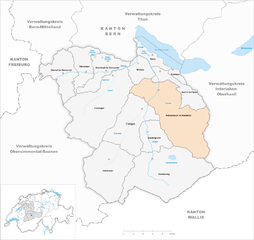
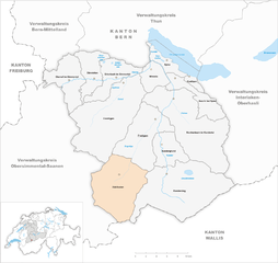
Фрутиген-Нидерсимментар (Frutigen-Niedersimmental administrative district, Verwaltungskreis Frutigen-Niedersimmental)

- административный район
 Hiking in Фрутиген-Нидерсимментар
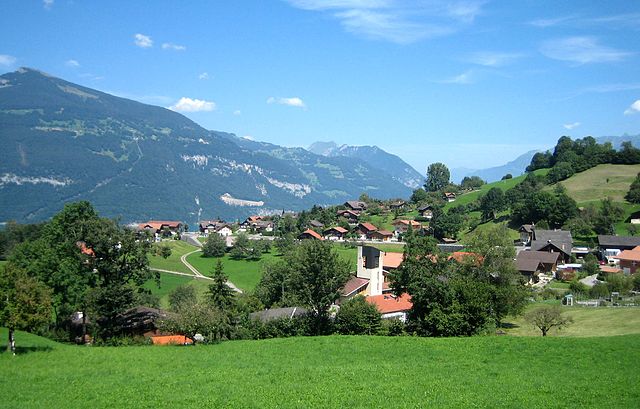
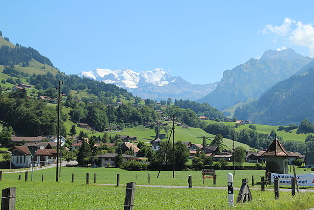
Frutigen-Niedersimmental is a picturesque region located in the Bernese Oberland of Switzerland, known for its stunning landscapes, diverse flora and fauna, and a network of well-marked hiking trails. Here are some highlights and tips for hiking in this beautiful area:
1.
- Frutigen to Kandersteg: This popular hike offers breathtaking views of the surrounding mountains, including the famous Via Alpina route.
- Hiking to Oeschinen Lake: From Kandersteg, you can hike to the stunning Oeschinen Lake, a UNESCO World Heritage site. The trail offers easy access to lakeside views and opportunities for swimming in summer.
- Hike around the Blüemlisalp Region: This trail provides a more challenging option, leading you through higher altitudes with panoramic views of glaciers and alpine lakes.
2.
- The region is rich in biodiversity. Keep an eye out for various alpine wildlife, including chamois and marmots. The area also features beautiful wildflowers, particularly in late spring and early summer.
3.
- The trails in Frutigen-Niedersimmental cater to all skill levels, from easy, family-friendly paths to more rugged and demanding hikes suitable for experienced hikers. Be sure to choose a trail that matches your fitness level.
4.
- Hiking in the region is best during the warmer months from May to October. However, early summer can be wet due to melting snow, so always check trail conditions and weather forecasts before heading out.
5.
- Frutigen-Niedersimmental has a range of accommodations, from campsites to hotels. You can often find mountain huts along the trails where you can enjoy local Swiss cuisine and refreshments.
6.
- Always carry adequate water, snacks, and a map or GPS device. Prepare for changing weather conditions, which can vary rapidly in the mountains.
- Wear proper footwear and consider trekking poles for stability, especially on uneven terrain.
7.
- Along your hikes, you may encounter traditional Swiss chalets and farms, offering insight into local culture. If you're interested, take time to visit small villages and learn about their heritage.
Conclusion:
Hiking in the Frutigen-Niedersimmental region is an excellent way to experience the natural beauty of Switzerland. Whether you're looking for leisurely strolls or challenging treks, this area has something to offer every hiking enthusiast. Always remember to be respectful of nature and the local communities you encounter on your adventures.
- Страна:

- Столица: Фрутиген
- Код автомобильного номера: BE
- Координаты: 46° 35' 0" N, 7° 39' 0" E


- GPS треки (wikiloc): [Ссылка]
- Высота над уровнем моря: 1605 м m
- Площадь: 774 кв.км
- Википедия английская: wiki(en)
- Википедия национальная: wiki(de)
- Хранилище Wikidata: Wikidata: Q661974
- Катеория в википедии: [Ссылка]
- код Freebase: [/m/0bhbjp4]
- код GeoNames: Альт: [8260135]
- идентификатор местоположения ArchINFORM: [42769]
Включает регионы:


Кандергрунд
Hiking in Кандергрунд
Kandergrund is a picturesque village located in the Bernese Oberland region of Switzerland, known for its stunning landscapes and numerous hiking trails. Here are some key points about hiking in this beautiful area:...
- Страна:
- Почтовый код: 3716
- Телефонный код: 033
- Код автомобильного номера: BE
- Координаты: 46° 32' 10" N, 7° 40' 37" E
- GPS треки (wikiloc): [Ссылка]
- Высота над уровнем моря: 1310 м m
- Площадь: 32.1 кв.км
- Население: 780
- Веб сайт: [Ссылка]


Дерштеттен
Hiking in Дерштеттен
Därstetten, a picturesque village in the Bernese Oberland region of Switzerland, offers excellent opportunities for hiking enthusiasts. Surrounded by stunning alpine scenery, the area provides a variety of trails suitable for different skill levels, from leisurely walks to more challenging hikes....
- Страна:
- Почтовый код: 3763
- Телефонный код: 033
- Код автомобильного номера: BE
- Координаты: 46° 40' 19" N, 7° 29' 18" E
- GPS треки (wikiloc): [Ссылка]
- Высота над уровнем моря: 1329 м m
- Площадь: 32.8 кв.км
- Население: 862
- Веб сайт: [Ссылка]


Виммис
Hiking in Виммис
Wimmis, located in the Bernese Oberland region of Switzerland, is a charming village surrounded by stunning mountain scenery, making it an excellent destination for hiking enthusiasts. Here are some details about hiking in and around Wimmis:...
- Страна:
- Почтовый код: 3752
- Телефонный код: 033
- Код автомобильного номера: BE
- Координаты: 46° 40' 31" N, 7° 38' 15" E
- GPS треки (wikiloc): [Ссылка]
- Высота над уровнем моря: 1039 м m
- Площадь: 22.23 кв.км
- Население: 2446
- Веб сайт: [Ссылка]

Краттиген
Hiking in Краттиген
Krattigen is a charming village located in the Bernese Oberland region of Switzerland, known for its stunning views of Lake Thun and the surrounding mountains. This area is a fantastic destination for hiking enthusiasts, offering a variety of trails suitable for different skill levels. Here are some highlights and tips for hiking in and around Krattigen:...
- Страна:
- Почтовый код: 3704
- Телефонный код: 033
- Код автомобильного номера: BE
- Координаты: 46° 39' 1" N, 7° 44' 25" E
- GPS треки (wikiloc): [Ссылка]
- Высота над уровнем моря: 932 м m
- Площадь: 6.0 кв.км
- Население: 1128
- Веб сайт: [Ссылка]


Димтиген
Hiking in Димтиген
Diemtigen is a beautiful region in Switzerland, located in the Bernese Oberland, known for its stunning landscapes, lush green valleys, and picturesque alpine scenery. Hiking in Diemtigen offers a range of trails suitable for various skill levels, from leisurely walks to challenging hikes. Here are some key points to consider when hiking in Diemtigen:...
- Страна:
- Почтовый код: 3754
- Телефонный код: 033
- Код автомобильного номера: BE
- Координаты: 46° 38' 58" N, 7° 33' 54" E
- GPS треки (wikiloc): [Ссылка]
- Высота над уровнем моря: 1565 м m
- Площадь: 129.94 кв.км
- Население: 2200
- Веб сайт: [Ссылка]


Эрленбах
- община в Швейцарии, Берн
Hiking in Эрленбах
Erlenbach im Simmental is a picturesque village located in the Simmental Valley of the Bernese Oberland region in Switzerland. This area is renowned for its stunning landscapes, charming Swiss architecture, and a plethora of hiking trails suitable for all skill levels. Here are some highlights and tips for hiking in Erlenbach im Simmental:...
- Страна:
- Почтовый код: 3762
- Телефонный код: 033
- Код автомобильного номера: BE
- Координаты: 46° 39' 39" N, 7° 33' 10" E
- GPS треки (wikiloc): [Ссылка]
- Высота над уровнем моря: 757 м m
- Площадь: 36.73 кв.км
- Население: 1733
- Веб сайт: [Ссылка]


Фрутиген
Hiking in Фрутиген
Frutigen, located in the Bernese Oberland region of Switzerland, is a fantastic destination for hiking enthusiasts. Nestled between majestic mountains and lush valleys, it offers a variety of trails suitable for all skill levels, from leisurely walks to more challenging hikes. Here are some highlights of hiking in Frutigen:...
- Страна:
- Почтовый код: 3714
- Телефонный код: 033
- Код автомобильного номера: BE
- Координаты: 46° 33' 30" N, 7° 37' 1" E
- GPS треки (wikiloc): [Ссылка]
- Высота над уровнем моря: 918 м m
- Площадь: 71.8 кв.км
- Население: 6917
- Веб сайт: [Ссылка]


Кандерштег
Hiking in Кандерштег
Kandersteg is a picturesque village located in the Bernese Oberland region of Switzerland, surrounded by stunning mountain ranges, lush valleys, and enchanting alpine scenery. It's a fantastic destination for hiking enthusiasts of all levels, offering a variety of trails with breathtaking views....
- Страна:
- Почтовый код: 3718
- Телефонный код: 033
- Код автомобильного номера: BE
- Координаты: 46° 28' 9" N, 7° 42' 30" E
- GPS треки (wikiloc): [Ссылка]
- Высота над уровнем моря: 2662 м m
- Площадь: 134.5 кв.км
- Население: 1301
- Веб сайт: [Ссылка]
Райхенбах
- община швейцарии в Швейцарии, Берн
Hiking in Райхенбах
Reichenbach im Kandertal, located in Switzerland, is a beautiful destination for hiking enthusiasts. Situated in the Bernese Oberland, the area boasts stunning landscapes characterized by rolling hills, lush valleys, and impressive mountain views. Here are some key aspects of hiking in Reichenbach im Kandertal:...
- Страна:
- Почтовый код: 3713
- Телефонный код: 033
- Код автомобильного номера: BE
- Координаты: 46° 34' 31" N, 7° 44' 13" E
- GPS треки (wikiloc): [Ссылка]
- Высота над уровнем моря: 1081 м m
- Площадь: 125.8 кв.км
- Население: 3616
- Веб сайт: [Ссылка]


Обервиль
Hiking in Обервиль
Oberwil im Simmental, located in the picturesque Simmental Valley of Switzerland, offers a variety of hiking opportunities for all skill levels. The region is known for its stunning alpine scenery, lush meadows, and charming Swiss villages. Here are some highlights and tips for hiking in Oberwil im Simmental:...
- Страна:
- Почтовый код: 3765
- Телефонный код: 033
- Код автомобильного номера: BE
- Координаты: 46° 38' 59" N, 7° 26' 0" E
- GPS треки (wikiloc): [Ссылка]
- Высота над уровнем моря: 836 м m
- Площадь: 46.09 кв.км
- Население: 797
- Веб сайт: [Ссылка]

Эши-Шпиц
Hiking in Эши-Шпиц
Aeschi bei Spiez is a charming village located in the Bernese Oberland region of Switzerland, offering a range of hiking opportunities with stunning views of the surrounding landscape, including Lake Thun and the majestic Alps. Here are some highlights for hiking in Aeschi bei Spiez:...
- Страна:
- Почтовый код: 3703
- Телефонный код: 033
- Код автомобильного номера: BE
- Координаты: 46° 37' 25" N, 7° 44' 55" E
- GPS треки (wikiloc): [Ссылка]
- Высота над уровнем моря: 1268 м m
- Площадь: 30.9 кв.км
- Население: 2285
- Веб сайт: [Ссылка]

Адельбоден
Hiking in Адельбоден
Adelboden, located in the Bernese Oberland region of Switzerland, is a fantastic destination for hiking enthusiasts. Surrounded by breathtaking alpine scenery, lush meadows, and impressive mountain peaks, it offers a diverse range of hiking trails suited for all levels of experience....
- Страна:
- Почтовый код: 3715
- Телефонный код: 033
- Код автомобильного номера: BE
- Координаты: 46° 28' 25" N, 7° 33' 19" E
- GPS треки (wikiloc): [Ссылка]
- Высота над уровнем моря: 1457 м m
- Площадь: 88.2 кв.км
- Население: 3371
- Веб сайт: [Ссылка]


Шпиц
Hiking in Шпиц
Spiez, located on the shores of Lake Thun in Switzerland, is a picturesque town surrounded by stunning landscapes and offers a variety of hiking opportunities for all levels of hikers. Here are some highlights and recommendations for hiking in and around Spiez:...
- Страна:
- Почтовый код: 3700
- Код автомобильного номера: BE
- Координаты: 46° 40' 59" N, 7° 39' 59" E
- GPS треки (wikiloc): [Ссылка]
- Высота над уровнем моря: 607 м m
- Площадь: 16.8 кв.км
- Население: 12707
- Веб сайт: [Ссылка]