Гедерсдорф (Gedersdorf, Gedersdorf)
 Hiking in Гедерсдорф
Gedersdorf is located in the beautiful region of Lower Austria, not far from the city of Krems and the picturesque Wachau Valley. This area is known for its scenic landscapes, including vineyards, rolling hills, and charming villages, making it a wonderful destination for hiking enthusiasts.
Hiking Trails
-
Wine Hiking Trails: Gedersdorf is situated in a wine-growing region, and several trails offer the chance to hike through vineyards. These paths often provide stunning views of the Danube River and the nearby landscape, especially during the grape harvest season.
-
Nature Trails: There are various nature trails around Gedersdorf where you can experience the local flora and fauna. These routes typically are well-marked and may lead through forests, fields, and alongside rivers.
-
Historical Routes: Some hiking trails in the area may offer insights into the local history, including historical sites, old churches, and traditional buildings. Hiking combined with a bit of local culture can make for a rewarding experience.
Recommendations
- Equipment: Wear comfortable hiking shoes, bring water, and consider a hat and sunscreen, particularly in the warmer months.
- Navigation: Download a hiking map or use a mobile app to help navigate your routes, especially if you're exploring less-marked trails.
- Timing: Spring and autumn are ideal for hiking in Gedersdorf due to mild weather and the beautiful scenery. However, summer can also be lovely for early morning or late afternoon hikes.
Local Amenities
Gedersdorf has a selection of small local inns and restaurants where you can enjoy regional cuisine after a day of hiking. Don’t miss out on tasting local wines!
Safety Tips
- Inform someone of your hiking plans if you’re going solo or venturing into more remote areas.
- Respect local wildlife and nature, staying on designated paths and leaving no trace.
With its combination of natural beauty and cultural richness, Gedersdorf is an excellent spot for a hiking adventure!
- Страна:

- Почтовый код: 3494
- Телефонный код: 02735
- Код автомобильного номера: KR
- Координаты: 48° 26' 1" N, 15° 41' 14" E


- GPS треки (wikiloc): [Ссылка]
- Высота над уровнем моря: 194 м m
- Площадь: 18.87 кв.км
- Население: 2184
- Веб сайт: http://www.gedersdorf.at/
- Википедия русская: wiki(ru)
- Википедия английская: wiki(en)
- Википедия национальная: wiki(de)
- Хранилище Wikidata: Wikidata: Q579202
- Катеория в википедии: [Ссылка]
- код Freebase: [/m/02qxcdc]
- код GeoNames: Альт: [7872914]
- код VIAF: Альт: [142250445]
- код GND: Альт: [4799167-7]
- идентификатор местоположения ArchINFORM: [10068]
- код австрийского муниципалитета: [31310]
Граничит с регионами:
Кремс-ан-дер-Донау
- город в Австрии
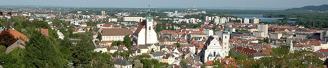
Hiking in Кремс-ан-дер-Донау
Krems an der Donau is a picturesque town in Lower Austria, situated at the confluence of the Danube River and the Krems River. It is surrounded by beautiful landscapes, vineyards, and the scenic rolling hills of the Wachau Valley, making it a great destination for hiking enthusiasts. Here are some highlights and tips for hiking in and around Krems an der Donau:...
- Страна:
- Почтовый код: 3500
- Код автомобильного номера: KS
- Координаты: 48° 25' 0" N, 15° 37' 0" E
- GPS треки (wikiloc): [Ссылка]
- Высота над уровнем моря: 203 м m
- Площадь: 51.61 кв.км
- Население: 24610
- Веб сайт: [Ссылка]

Трайсмауэр
Hiking in Трайсмауэр
Traismauer is a charming town in Lower Austria that offers a variety of hiking opportunities, especially for those looking to explore the scenic beauty of the region. Here are some highlights for hiking in and around Traismauer:...
- Страна:
- Почтовый код: 3133
- Код автомобильного номера: PL
- Координаты: 48° 20' 0" N, 15° 43' 59" E
- GPS треки (wikiloc): [Ссылка]
- Высота над уровнем моря: 197 м m
- Площадь: 43.14 кв.км
- Население: 6224
- Веб сайт: [Ссылка]

Графенег
Hiking in Графенег
Grafenegg, located in Austria, is renowned for its picturesque landscapes, charming vineyards, and historical sites, making it an appealing destination for hiking enthusiasts. The area offers a variety of trails suited for different skill levels, from leisurely walks to more challenging hikes....
- Страна:
- Почтовый код: 3492
- Телефонный код: 02735
- Код автомобильного номера: KR
- Координаты: 48° 25' 48" N, 15° 44' 51" E
- GPS треки (wikiloc): [Ссылка]
- Высота над уровнем моря: 197 м m
- Площадь: 28.58 кв.км
- Население: 3061
- Веб сайт: [Ссылка]

Лангенлойс
Hiking in Лангенлойс
Langenlois, located in the beautiful wine region of Lower Austria, offers an array of hiking opportunities that allow visitors to explore its picturesque landscapes, vineyards, and charming villages. Here are some highlights of hiking in and around Langenlois:...
- Страна:
- Почтовый код: 3550
- Телефонный код: 02734
- Код автомобильного номера: KR
- Координаты: 48° 28' 0" N, 15° 41' 0" E
- GPS треки (wikiloc): [Ссылка]
- Высота над уровнем моря: 219 м m
- Площадь: 67.12 кв.км
- Население: 7609
- Веб сайт: [Ссылка]

Графенвёрт
Hiking in Графенвёрт
Grafenwörth, located in Austria, is a charming destination for hiking enthusiasts. Nestled along the banks of the Danube River and surrounded by beautiful landscapes, it offers several trails that cater to various skill levels. Here are some key points about hiking in Grafenwörth:...
- Страна:
- Почтовый код: 3484
- Телефонный код: 02738
- Код автомобильного номера: TU
- Координаты: 48° 24' 24" N, 15° 46' 43" E
- GPS треки (wikiloc): [Ссылка]
- Высота над уровнем моря: 190 м m
- Площадь: 46.4 кв.км
- Население: 3132
- Веб сайт: [Ссылка]

Рорендорф-Кремс
Hiking in Рорендорф-Кремс
Rohrendorf bei Krems is a picturesque village located in the Krems-Land district of Austria's Lower Austria region. Nestled along the banks of the Danube River near the Wachau Valley, it offers an array of hiking opportunities that showcase the beautiful landscapes, vineyards, and historic sites that characterize this area....
- Страна:
- Почтовый код: 3495
- Телефонный код: 02732
- Код автомобильного номера: KR
- Координаты: 48° 25' 0" N, 15° 39' 0" E
- GPS треки (wikiloc): [Ссылка]
- Высота над уровнем моря: 194 м m
- Площадь: 9.78 кв.км
- Население: 2091
- Веб сайт: [Ссылка]