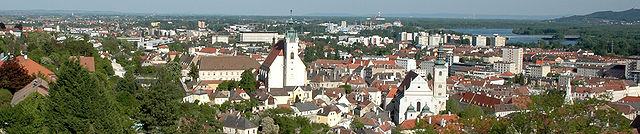
Лангенлойс (Langenlois, Langenlois)
 Hiking in Лангенлойс
Langenlois, located in the beautiful wine region of Lower Austria, offers an array of hiking opportunities that allow visitors to explore its picturesque landscapes, vineyards, and charming villages. Here are some highlights of hiking in and around Langenlois:
Hiking Trails
-
The “Weinweg” (Wine Trail): This is one of the most popular trails in the area, winding through vineyards and offering stunning views of the surrounding hills and the Kamp River. It’s a great way to experience the local viticulture.
-
Natural Landscapes: The region features several trails that navigate through the scenic forests of the Waldviertel and along the banks of the Kamp River, providing opportunities to enjoy nature and wildlife.
-
Kunstwanderweg (Art Hiking Trail): This trail integrates hiking with art, showcasing various sculptures and installations along the route. It is a unique way to experience both nature and creativity.
Hiking Season
The best time to hike in Langenlois is typically from late spring to early autumn (May to October) when the weather is mild, and the landscapes are vibrant. Autumn is also a fantastic time, especially for experiencing the vine harvest and the changing colors of the foliage.
Amenities
- Wine Cellars: After a day of hiking, you can enjoy local wines at one of the many heurigen (wine taverns) or wineries in Langenlois.
- Guided Tours: Local hiking guides often offer organized tours, providing insights into the area’s history, ecology, and wine production.
- Trail Information: Local tourist information centers can provide maps and suggestions for various hiking routes based on your experience level.
Tips for Hiking in Langenlois
- Footwear: Wear sturdy hiking shoes, as trails can vary in difficulty.
- Hydration and Snacks: Carry enough water and some snacks, especially on longer hikes.
- Weather Gear: Be prepared for changing weather conditions by bringing layers and waterproof gear if needed.
- Respect Nature: Stay on marked trails and follow local regulations to preserve the beauty of the area.
Hiking in Langenlois is an enjoyable way to connect with nature and experience the region's rich culture and culinary delights, especially its renowned wines.
- Страна:

- Почтовый код: 3550
- Телефонный код: 02734
- Код автомобильного номера: KR
- Координаты: 48° 28' 0" N, 15° 41' 0" E


- GPS треки (wikiloc): [Ссылка]
- Высота над уровнем моря: 219 м m
- Площадь: 67.12 кв.км
- Население: 7609
- Веб сайт: http://www.langenlois.at
- Википедия русская: wiki(ru)
- Википедия английская: wiki(en)
- Википедия национальная: wiki(de)
- Хранилище Wikidata: Wikidata: Q672511
- Катеория в википедии: [Ссылка]
- код Freebase: [/m/02qxcvt]
- код GeoNames: Альт: [2773010]
- код VIAF: Альт: [147763009]
- код GND: Альт: [4099034-5]
- идентификатор местоположения ArchINFORM: [9582]
- код LCNAF: Альт: [n82005903]
- код австрийского муниципалитета: [31322]
- код Цифрового атласа Римской империи: [42786]
Граничит с регионами:
Кремс-ан-дер-Донау
- город в Австрии
Hiking in Кремс-ан-дер-Донау
Krems an der Donau is a picturesque town in Lower Austria, situated at the confluence of the Danube River and the Krems River. It is surrounded by beautiful landscapes, vineyards, and the scenic rolling hills of the Wachau Valley, making it a great destination for hiking enthusiasts. Here are some highlights and tips for hiking in and around Krems an der Donau:...
- Страна:
- Почтовый код: 3500
- Код автомобильного номера: KS
- Координаты: 48° 25' 0" N, 15° 37' 0" E
- GPS треки (wikiloc): [Ссылка]
- Высота над уровнем моря: 203 м m
- Площадь: 51.61 кв.км
- Население: 24610
- Веб сайт: [Ссылка]

Гедерсдорф
Hiking in Гедерсдорф
Gedersdorf is located in the beautiful region of Lower Austria, not far from the city of Krems and the picturesque Wachau Valley. This area is known for its scenic landscapes, including vineyards, rolling hills, and charming villages, making it a wonderful destination for hiking enthusiasts....
- Страна:
- Почтовый код: 3494
- Телефонный код: 02735
- Код автомобильного номера: KR
- Координаты: 48° 26' 1" N, 15° 41' 14" E
- GPS треки (wikiloc): [Ссылка]
- Высота над уровнем моря: 194 м m
- Площадь: 18.87 кв.км
- Население: 2184
- Веб сайт: [Ссылка]

Хадерсдорф-Каммерн
Hiking in Хадерсдорф-Каммерн
Hadersdorf-Kammern is a quaint village in Austria, surrounded by beautiful natural landscapes that make it a great spot for hiking enthusiasts. Located in the Lower Austria region, it offers a variety of trails suitable for different skill levels....
- Страна:
- Почтовый код: 3493
- Телефонный код: 02735
- Код автомобильного номера: KR
- Координаты: 48° 27' 21" N, 15° 43' 14" E
- GPS треки (wikiloc): [Ссылка]
- Высота над уровнем моря: 202 м m
- Площадь: 4.8 кв.км
- Население: 2009
- Веб сайт: [Ссылка]

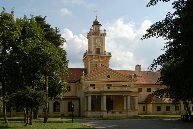
Графенег
Hiking in Графенег
Grafenegg, located in Austria, is renowned for its picturesque landscapes, charming vineyards, and historical sites, making it an appealing destination for hiking enthusiasts. The area offers a variety of trails suited for different skill levels, from leisurely walks to more challenging hikes....
- Страна:
- Почтовый код: 3492
- Телефонный код: 02735
- Код автомобильного номера: KR
- Координаты: 48° 25' 48" N, 15° 44' 51" E
- GPS треки (wikiloc): [Ссылка]
- Высота над уровнем моря: 197 м m
- Площадь: 28.58 кв.км
- Население: 3061
- Веб сайт: [Ссылка]

Санкт-Леонхард-ам-Хорнервальд
Hiking in Санкт-Леонхард-ам-Хорнервальд
Sankt Leonhard am Hornerwald is a charming village in Lower Austria, known for its beautiful landscapes and scenic hiking opportunities. This region offers a variety of trails that cater to different skill levels and preferences, making it an excellent destination for both casual hikers and seasoned trekkers....
- Страна:
- Почтовый код: 3572
- Телефонный код: 02987
- Код автомобильного номера: KR
- Координаты: 48° 35' 0" N, 15° 32' 0" E
- GPS треки (wikiloc): [Ссылка]
- Высота над уровнем моря: 582 м m
- Площадь: 51.57 кв.км
- Население: 1119
- Веб сайт: [Ссылка]

Штрас-им-Штрассертале
Hiking in Штрас-им-Штрассертале
Straß im Straßertale, located in Austria's beautiful wine country in Lower Austria, is an excellent destination for hiking enthusiasts. Nestled in the rolling hills and vineyards, it offers various scenic trails that cater to different skill levels. Here are some highlights about hiking in this area:...
- Страна:
- Почтовый код: 3491
- Телефонный код: 02735
- Код автомобильного номера: KR
- Координаты: 48° 28' 0" N, 15° 44' 0" E
- GPS треки (wikiloc): [Ссылка]
- Высота над уровнем моря: 217 м m
- Площадь: 22.49 кв.км
- Население: 1678
- Веб сайт: [Ссылка]

Рорендорф-Кремс
Hiking in Рорендорф-Кремс
Rohrendorf bei Krems is a picturesque village located in the Krems-Land district of Austria's Lower Austria region. Nestled along the banks of the Danube River near the Wachau Valley, it offers an array of hiking opportunities that showcase the beautiful landscapes, vineyards, and historic sites that characterize this area....
- Страна:
- Почтовый код: 3495
- Телефонный код: 02732
- Код автомобильного номера: KR
- Координаты: 48° 25' 0" N, 15° 39' 0" E
- GPS треки (wikiloc): [Ссылка]
- Высота над уровнем моря: 194 м m
- Площадь: 9.78 кв.км
- Население: 2091
- Веб сайт: [Ссылка]
Яидхоф
Hiking in Яидхоф
Jaidhof, a picturesque region in Austria, is known for its beautiful landscapes and tranquil hiking trails. Nestled in the foothills of the Alps, this area offers a variety of hiking experiences suitable for different skill levels. Here are some highlights for those interested in hiking in Jaidhof:...
- Страна:
- Почтовый код: 3542
- Телефонный код: 02716
- Код автомобильного номера: KR
- Координаты: 48° 32' 0" N, 15° 29' 0" E
- GPS треки (wikiloc): [Ссылка]
- Высота над уровнем моря: 592 м m
- Площадь: 44.93 кв.км
- Население: 1225
- Веб сайт: [Ссылка]

Штратцинг
Hiking in Штратцинг
Stratzing is a charming village located in Austria, nestled within the beautiful landscape of the Wachau Valley. This region is renowned for its vineyards, rolling hills, and lovely riverside views along the Danube River. Hiking in Stratzing offers a unique blend of natural beauty and cultural experiences, making it a fantastic destination for outdoor enthusiasts....
- Страна:
- Почтовый код: 3552
- Телефонный код: 02719
- Код автомобильного номера: KR
- Координаты: 48° 27' 0" N, 15° 36' 0" E
- GPS треки (wikiloc): [Ссылка]
- Высота над уровнем моря: 352 м m
- Площадь: 5.84 кв.км
- Население: 827
- Веб сайт: [Ссылка]

Шёнберг-ам-Камп
Hiking in Шёнберг-ам-Камп
Schönberg am Kamp, located in Lower Austria, is a charming destination for hiking enthusiasts. The area is characterized by its beautiful natural landscapes, rolling hills, and lush vineyards, making it an ideal spot for outdoor activities....
- Страна:
- Телефонный код: 02733
- Код автомобильного номера: KR
- Координаты: 48° 31' 0" N, 15° 42' 0" E
- GPS треки (wikiloc): [Ссылка]
- Высота над уровнем моря: 226 м m
- Площадь: 53.28 кв.км
- Население: 1903
- Веб сайт: [Ссылка]

Гфёль
- город в Австрии
Hiking in Гфёль
Gföhl, located in the beautiful state of Lower Austria, is a charming area that offers various hiking opportunities, especially for those who appreciate picturesque landscapes and serene nature. Here are some key points to consider if you're planning a hiking trip in Gföhl:...
- Страна:
- Почтовый код: 3542
- Телефонный код: 02716
- Код автомобильного номера: KR
- Координаты: 48° 31' 0" N, 15° 29' 0" E
- GPS треки (wikiloc): [Ссылка]
- Высота над уровнем моря: 579 м m
- Площадь: 80.75 кв.км
- Население: 3783
- Веб сайт: [Ссылка]

Ленгенфельд
Hiking in Ленгенфельд
Lengenfeld, located in the beautiful landscapes of Austria, is an excellent destination for hiking enthusiasts. Nestled in the region of Styria, Lengenfeld offers a mix of alpine scenery, lush valleys, and diverse flora and fauna. Here are some highlights and considerations for hiking in Lengenfeld:...
- Страна:
- Почтовый код: 3552
- Телефонный код: 02719
- Код автомобильного номера: KR
- Координаты: 48° 28' 0" N, 15° 35' 0" E
- GPS треки (wikiloc): [Ссылка]
- Высота над уровнем моря: 315 м m
- Площадь: 15.01 кв.км
- Население: 1412
- Веб сайт: [Ссылка]