Gouhelans (Gouhelans)

- коммуна во Франции
 Hiking in Gouhelans
Gouhelans, also known as Gouhelans in French, is a picturesque area that typically offers beautiful landscapes, diverse ecosystems, and various trails suitable for hiking enthusiasts of all levels. As a hiking instructor familiar with the region, I can highlight some key aspects that make hiking in Gouhelans appealing:
Natural Beauty
-
Scenic Views: The area is known for its stunning views, often featuring rolling hills, lush forests, and serene rivers or lakes. The landscape can vary greatly depending on the season, offering unique experiences throughout the year.
-
Flora and Fauna: Hiking in Gouhelans allows you to explore a variety of natural habitats. You may encounter various plants and wildlife, making it a great spot for nature lovers and bird watchers.
Hiking Trails
-
Trail Variability: There are trails suited for all skill levels, from easy, family-friendly walks to more challenging treks for experienced hikers. Specific trails may wind through forests, along water bodies, or up hills for panoramic views.
-
Trail Markings: Many trails are well-marked, making navigation easier. It's advisable to carry a map or use a hiking app to complement trail markings.
Accessibility
- Transport Options: Depending on the location, Gouhelans may be accessible via public transport or a short drive from nearby towns, making it easier to plan your hiking trips.
Safety and Preparedness
-
Weather Considerations: Check the local weather forecasts before heading out, as conditions can change quickly in mountainous or forested areas. Dress in layers and prepare for potential rain or temperature changes.
-
Equipment: Good hiking boots are essential, as well as carrying essentials like water, snacks, a first aid kit, and a compass or GPS device.
Local Culture
- Community and Events: Sometimes, local communities host hiking events or guided tours that can enhance your experience by providing insights into the local culture and natural history.
If you're planning a hike in Gouhelans, consider your experience level, choose the right trail, and always prioritize safety. Enjoy exploring the natural beauty this area has to offer!
- Страна:

- Почтовый код: 25680
- Координаты: 47° 27' 22" N, 6° 21' 11" E


- GPS треки (wikiloc): [Ссылка]
- Площадь: 6.17 кв.км
- Население: 110
- Википедия английская: wiki(en)
- Википедия национальная: wiki(fr)
- Хранилище Wikidata: Wikidata: Q836633
- Катеория в википедии: [Ссылка]
- код Freebase: [/m/03mh9r7]
- код Freebase: [/m/03mh9r7]
- код GeoNames: Альт: [6429810]
- код GeoNames: Альт: [6429810]
- номер SIREN: [212502793]
- номер SIREN: [212502793]
- код BNF: [15252505t]
- код BNF: [15252505t]
- код муниципалитета INSEE: 25279
- код муниципалитета INSEE: 25279
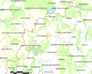
Граничит с регионами:


Puessans
- коммуна во Франции
Hiking in Puessans
It seems there might be a typo or misunderstanding in your request, as "Puessans" doesn't appear to correspond to a well-known hiking area or location. If you meant "Puslinch", located in Ontario, Canada, or perhaps "Puget Sound" in Washington state, I can provide information on those areas....
- Страна:
- Почтовый код: 25680
- Координаты: 47° 25' 47" N, 6° 19' 23" E
- GPS треки (wikiloc): [Ссылка]
- Площадь: 3.59 кв.км
- Население: 32


Romain
- коммуна во Франции
Hiking in Romain
Hiking in Romain, located in the Doubs department of France, offers a wonderful opportunity to explore the scenic beauty of the Franche-Comté region. Doubs is known for its lush forests, rolling hills, and numerous rivers, making it a great destination for outdoor enthusiasts....
- Страна:
- Почтовый код: 25680
- Координаты: 47° 26' 35" N, 6° 22' 28" E
- GPS треки (wikiloc): [Ссылка]
- Высота над уровнем моря: 352 м m
- Площадь: 4.85 кв.км
- Население: 132

Rougemont
Hiking in Rougemont
Rougemont, located in the Doubs department of France, is a picturesque destination that offers excellent hiking opportunities amidst beautiful natural landscapes. Here's an overview of what you can expect when hiking in this area:...
- Страна:
- Почтовый код: 25680
- Координаты: 47° 28' 52" N, 6° 21' 18" E
- GPS треки (wikiloc): [Ссылка]
- Площадь: 18.33 кв.км
- Население: 1173
- Веб сайт: [Ссылка]