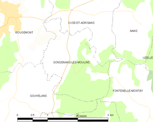
Romain (Romain)

- коммуна во Франции
 Hiking in Romain
Hiking in Romain, located in the Doubs department of France, offers a wonderful opportunity to explore the scenic beauty of the Franche-Comté region. Doubs is known for its lush forests, rolling hills, and numerous rivers, making it a great destination for outdoor enthusiasts.
Popular Hiking Trails
-
Les Gorges de la Loue: This is one of the most stunning areas for hiking in the region. The gorge offers breathtaking views and well-marked trails alongside the Loue River. The diverse fauna and flora and opportunities for photography make this a favorite among hikers.
-
Sentier des Cimes: This trail takes you through picturesque forests and over ridges, providing panoramic views of the surrounding landscape, particularly in the fall when the foliage changes color.
-
Le Circuit des Crêtes: This trail takes you along the ridges of the Jura mountains, offering spectacular views of both the Doubs region and the Swiss Alps on clear days.
Best Time to Hike
The best time to hike in the Doubs region is during the spring (April to June) and the fall (September to October) when the weather is mild, and the scenery is particularly beautiful. Summers can be warm, while winters can bring snow, particularly in higher elevations, making some trails less accessible.
What to Bring
- Good Footwear: Sturdy, comfortable hiking boots are essential.
- Weather Gear: The weather can change quickly in the mountains, so pack layers and a waterproof jacket.
- Map and Compass/GPS: While many trails are well-marked, it’s always wise to have a map or a GPS device.
- Hydration and Snacks: Carry enough water and snacks to keep your energy up on the trails.
Safety Tips
- Always inform someone about your hiking plans.
- Be mindful of trail conditions and check for any advisories.
- Stay on marked trails to protect the environment.
- If hiking in less populated areas, consider bringing a first-aid kit.
Hiking in Romain and the surrounding Doubs region gives you the chance to experience the natural beauty and tranquility of Franche-Comté. Enjoy your adventure!
- Страна:

- Почтовый код: 25680
- Координаты: 47° 26' 35" N, 6° 22' 28" E


- GPS треки (wikiloc): [Ссылка]
- Высота над уровнем моря: 352 м m
- Площадь: 4.85 кв.км
- Население: 132
- Википедия английская: wiki(en)
- Википедия национальная: wiki(fr)
- Хранилище Wikidata: Wikidata: Q637617
- Катеория в википедии: [Ссылка]
- код Freebase: [/m/03nnk79]
- код Freebase: [/m/03nnk79]
- код GeoNames: Альт: [6616234]
- код GeoNames: Альт: [6616234]
- номер SIREN: [212504997]
- номер SIREN: [212504997]
- код BNF: [152527250]
- код BNF: [152527250]
- код муниципалитета INSEE: 25499
- код муниципалитета INSEE: 25499
Граничит с регионами:

Huanne-Montmartin
- коммуна во Франции
Hiking in Huanne-Montmartin
Huanne-Montmartin is a picturesque commune located in the Vosges department of northeastern France, known for its scenic landscapes and outdoor activities, including hiking. The region offers a mix of lush forests, rolling hills, and vibrant flora and fauna, making it an attractive destination for both casual walkers and trekking enthusiasts....
- Страна:
- Почтовый код: 25680
- Координаты: 47° 25' 52" N, 6° 20' 40" E
- GPS треки (wikiloc): [Ссылка]
- Площадь: 3.43 кв.км
- Население: 83

Gondenans-les-Moulins
- коммуна во Франции
Hiking in Gondenans-les-Moulins
Gondenans-les-Moulins, located in the Franche-Comté region of eastern France, is a charming village that offers several opportunities for hiking and enjoying the natural beauty of the surrounding countryside. Here are some key points about hiking in this area:...
- Страна:
- Почтовый код: 25680
- Координаты: 47° 28' 10" N, 6° 22' 54" E
- GPS треки (wikiloc): [Ссылка]
- Площадь: 3.93 кв.км
- Население: 76

Gouhelans
- коммуна во Франции
Hiking in Gouhelans
Gouhelans, also known as Gouhelans in French, is a picturesque area that typically offers beautiful landscapes, diverse ecosystems, and various trails suitable for hiking enthusiasts of all levels. As a hiking instructor familiar with the region, I can highlight some key aspects that make hiking in Gouhelans appealing:...
- Страна:
- Почтовый код: 25680
- Координаты: 47° 27' 22" N, 6° 21' 11" E
- GPS треки (wikiloc): [Ссылка]
- Площадь: 6.17 кв.км
- Население: 110


Fontenelle-Montby
- коммуна во Франции
Hiking in Fontenelle-Montby
Fontenelle-Montby is a beautiful area ideal for hiking enthusiasts, situated in the Jura Mountains of France. This region offers a range of scenic trails that cater to various skill levels, featuring lush forests, stunning vistas, and unique geological formations....
- Страна:
- Почтовый код: 25340
- Координаты: 47° 26' 58" N, 6° 24' 51" E
- GPS треки (wikiloc): [Ссылка]
- Площадь: 6.65 кв.км
- Население: 94


Mésandans
- коммуна во Франции
Hiking in Mésandans
Mésandans, while not widely known as a primary hiking destination, offers beautiful landscapes and a serene environment for outdoor enthusiasts. Since the area is less commercialized than many popular hiking spots, it can provide a more tranquil hiking experience. Here are some general tips and highlights about hiking in such regions:...
- Страна:
- Почтовый код: 25680
- Координаты: 47° 25' 51" N, 6° 22' 8" E
- GPS треки (wikiloc): [Ссылка]
- Площадь: 5.66 кв.км
- Население: 220