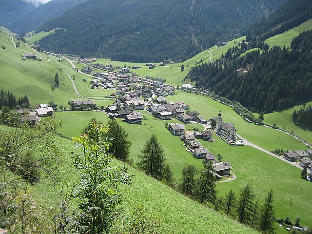
Валле-ди-Казиес (Gsies, Valle di Casies)
.svg)
- коммуна в Италии
 Hiking in Валле-ди-Казиес
Gsies, located in the South Tyrol region of northern Italy, is a picturesque valley surrounded by the stunning Dolomites and offers a variety of hiking opportunities. Here are some highlights and tips for hiking in Gsies:
Scenic Trails
-
Hiking Routes: Gsies boasts a diverse network of hiking trails, ranging from easy walks to more challenging hikes. The trails typically meander through lush meadows, dense forests, and along the Gsieser Bach river.
-
Panoramic Views: Many trails offer breathtaking views of the surrounding mountains. Notable vantage points can be reached via loop trails or up to scenic ridges.
-
Mountain Huts: The area is dotted with traditional mountain huts (Almhütten), where you can stop for refreshments and enjoy local dishes. These huts often provide a great chance to rest and take in the views.
Popular Hiking Routes
-
Valley Hikes: Routes along the Gsieser Bach are gentle and suitable for families. They provide beautiful views of the valley.
-
Higher Trails: For those seeking a more challenging adventure, trails that lead to the surrounding mountain peaks, such as the Peitlerkofel or the Großvenediger, are recommended.
-
The Gsieser Trail: A particularly popular route is the Gsieser Trail, which runs the length of the valley and connects various villages, making it an excellent option for multi-day hikes or day trips.
Seasonal Considerations
-
Spring & Summer: The best time for hiking in Gsies is during the warmer months when trails are generally dry and flowers are in bloom. Bring plenty of water and sunscreen, as some trails can be exposed to the sun.
-
Fall: Autumn offers stunning foliage, and the temperatures are still mild, making this a great time to hike as well.
-
Winter: Although winter hiking is possible, snow and ice may require specialized equipment, so check local conditions and trails suited for snowshoeing or winter walking.
Safety Tips
-
Map and GPS: Always carry a physical map or download offline maps, as cell service can be unreliable in mountainous areas.
-
Weather Awareness: Keep an eye on the weather forecast, as conditions can change rapidly in the mountains.
-
Footwear: Wear appropriate hiking boots or shoes with good grip, and dress in layers to manage varying temperatures.
Conclusion
Hiking in Gsies offers an incredible opportunity to immerse yourself in nature and explore the beauty of the Dolomites. Remember to pace yourself, enjoy the scenery, and take the time to experience the local culture along the way!
- Страна:

- Почтовый код: 39035
- Телефонный код: 0474
- Код автомобильного номера: BZ
- Координаты: 46° 46' 6" N, 12° 10' 46" E


- GPS треки (wikiloc): [Ссылка]
- Высота над уровнем моря: 1305 м m
- Площадь: 110.14 кв.км
- Население: 2329
- Веб сайт: http://www.comune.vallesannicolao.bi.it
- Википедия русская: wiki(ru)
- Википедия английская: wiki(en)
- Википедия национальная: wiki(it)
- Хранилище Wikidata: Wikidata: Q504650
- Галерея изображений в википедии: [Ссылка]
- Катеория в википедии: [Ссылка]
- код Freebase: [/m/0g9kxv]
- код GeoNames: Альт: [6536020]
- код VIAF: Альт: [148704589]
- ID отношения в OpenStreetMap: [47318]
- код GND: Альт: [10042978-6]
- код в Итальянской энциклопедии онлайн: [valle-di-casies]
- код ISTAT: 021109
- кадастровый код Италии: L601
Граничит с регионами:

Иннерфильгратен
Hiking in Иннерфильгратен
Innervillgraten, located in the picturesque East Tyrol region of Austria, is a hidden gem for hiking enthusiasts. Surrounded by stunning mountain scenery, this charming village offers a wealth of hiking trails suitable for various skill levels, making it a perfect destination for both families and serious trekkers....
- Страна:

- Почтовый код: 9932
- Телефонный код: 04843
- Код автомобильного номера: LZ
- Координаты: 46° 48' 24" N, 12° 22' 23" E
- GPS треки (wikiloc): [Ссылка]
- Высота над уровнем моря: 1402 м m
- Площадь: 87.8 кв.км
- Население: 938
- Веб сайт: [Ссылка]


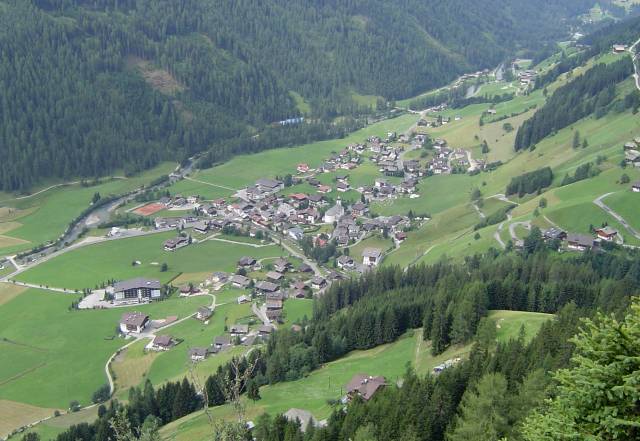
Разун-Антерсельва
- коммуна в Италии
Hiking in Разун-Антерсельва
Rasen-Antholz (Rasen-Antholz in German, or Rasun-Anterselva in Italian) is a picturesque valley located in the South Tyrol region of northern Italy, surrounded by the stunning Dolomites. This area is particularly popular for hiking due to its breathtaking landscapes, diverse trails, and natural beauty....
- Страна:
- Почтовый код: 39030
- Телефонный код: 0474
- Код автомобильного номера: BZ
- Координаты: 46° 51' 0" N, 12° 6' 0" E
- GPS треки (wikiloc): [Ссылка]
- Высота над уровнем моря: 1030 м m
- Площадь: 121.57 кв.км
- Население: 2907
- Веб сайт: [Ссылка]
Санкт-Якоб-ин-Деферегген
Hiking in Санкт-Якоб-ин-Деферегген
St. Jakob in Defereggen, located in the Austrian Alps in the East Tyrol region, is a fantastic destination for hiking enthusiasts. The area is known for its stunning natural landscapes, diverse flora and fauna, and breathtaking mountain views. Here are some key highlights about hiking in this beautiful area:...
- Страна:
- Почтовый код: 9963
- Телефонный код: 04873
- Код автомобильного номера: LZ
- Координаты: 46° 56' 30" N, 12° 14' 48" E
- GPS треки (wikiloc): [Ссылка]
- Высота над уровнем моря: 2570 м m
- Площадь: 186 кв.км
- Население: 848
- Веб сайт: [Ссылка]
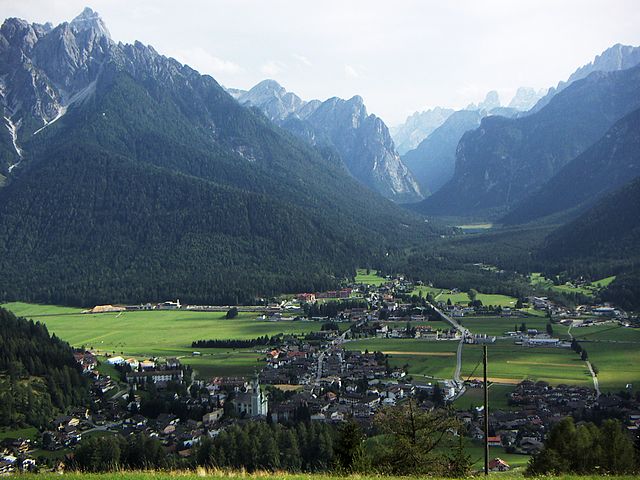

Доббьяко
- коммуна Италии
Hiking in Доббьяко
Toblach, located in the South Tyrol region of northern Italy, is a beautiful destination for hikers, thanks to its stunning landscapes and well-marked trails. Here’s an overview of what you can expect when hiking in Toblach:...
- Страна:
- Почтовый код: 39034
- Телефонный код: 0474
- Код автомобильного номера: BZ
- Координаты: 46° 44' 7" N, 12° 13' 20" E
- GPS треки (wikiloc): [Ссылка]
- Высота над уровнем моря: 1241 м m
- Площадь: 125.42 кв.км
- Население: 3346
- Веб сайт: [Ссылка]


Монгуэльфо-Тезидо
- коммуна Италии
Hiking in Монгуэльфо-Тезидо
Welsberg-Taisten is a beautiful hiking destination located in the South Tyrol region of northern Italy. Nestled in the Dolomites, it offers a wide range of hiking trails suitable for various skill levels, from easy strolls to challenging ascents. Here are some key points about hiking in this area:...
- Страна:
- Почтовый код: 39035
- Телефонный код: 0474
- Код автомобильного номера: BZ
- Координаты: 46° 45' 28" N, 12° 6' 20" E
- GPS треки (wikiloc): [Ссылка]
- Высота над уровнем моря: 1087 м m
- Площадь: 46.44 кв.км
- Население: 2867
- Веб сайт: [Ссылка]


Виллабасса
- коммуна в Италии
Hiking in Виллабасса
Niederdorf, located in the beautiful South Tyrol region of northern Italy, is a charming village surrounded by picturesque landscapes, making it a great destination for hiking enthusiasts. The area offers a variety of hiking trails that cater to different skill levels, from leisurely walks to challenging hikes....
- Страна:
- Почтовый код: 39039
- Телефонный код: 0474
- Код автомобильного номера: BZ
- Координаты: 46° 44' 16" N, 12° 10' 22" E
- GPS треки (wikiloc): [Ссылка]
- Высота над уровнем моря: 1154 м m
- Площадь: 18.03 кв.км
- Население: 1605
- Веб сайт: [Ссылка]