Иннерфильгратен (Innervillgraten, Innervillgraten)

 Hiking in Иннерфильгратен
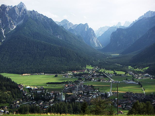
Innervillgraten, located in the picturesque East Tyrol region of Austria, is a hidden gem for hiking enthusiasts. Surrounded by stunning mountain scenery, this charming village offers a wealth of hiking trails suitable for various skill levels, making it a perfect destination for both families and serious trekkers.
Key Features of Hiking in Innervillgraten:
-
Breathtaking Scenery: The region is characterized by dramatic peaks, lush alpine meadows, and scenic valleys. The views of the Hohe Tauern National Park and the surrounding Dolomites create a stunning backdrop for your hikes.
-
Variety of Trails: There are numerous trails to explore, ranging from easy walks to challenging mountain ascents. Some popular routes include:
- Windbichl Hike: A moderately challenging hike that provides stunning views and a good alpine experience.
- Hochgall Trail: For experienced hikers, this trail leads to one of the highest peaks in the region, offering panoramic views of the entire area.
- Family-friendly Trails: There are several easy paths suitable for families, such as trails around the village that showcase local flora and fauna.
-
Wildlife and Nature: The area is home to diverse wildlife, including ibex, marmots, and various bird species. Hikers can enjoy the rich biodiversity while walking through pristine natural landscapes.
-
Historical Significance: The region has a rich cultural heritage, and some trails take you through historical sites, traditional alpine huts, and ancient paths that were once used by locals for trade.
-
Local Guides and Tours: For those looking to deepen their hiking experience, local guides offer tours that include information about the geology, flora, and fauna of the region.
-
Best Time to Visit: The ideal seasons for hiking in Innervillgraten are late spring through early autumn (May to September) when the weather is generally stable, and the trails are clear of snow.
-
Accommodation and Amenities: The village offers various accommodation options, from cozy guesthouses to hotels. Local eateries serve delicious Tyrolean cuisine, perfect for refueling after a day of hiking.
-
Accessibility: Innervillgraten is easily reachable by public transport or car, making it an accessible destination for both local and international visitors.
Safety Considerations:
- Always check the weather conditions before heading out.
- Wear appropriate hiking gear and footwear.
- Carry plenty of water and snacks, and consider a first-aid kit for emergencies.
- It’s advisable to inform someone about your hiking plans, especially if venturing into more remote areas.
With its captivating landscapes and well-maintained trails, Innervillgraten is a fantastic place to experience the beauty of the Austrian Alps while enjoying the serenity of nature. Happy hiking!
- Страна:

- Почтовый код: 9932
- Телефонный код: 04843
- Код автомобильного номера: LZ
- Координаты: 46° 48' 24" N, 12° 22' 23" E


- GPS треки (wikiloc): [Ссылка]
- Высота над уровнем моря: 1402 м m
- Площадь: 87.8 кв.км
- Население: 938
- Веб сайт: http://www.innervillgraten.at/
- Википедия русская: wiki(ru)
- Википедия английская: wiki(en)
- Википедия национальная: wiki(de)
- Хранилище Wikidata: Wikidata: Q186144
- Катеория в википедии: [Ссылка]
- код Freebase: [/m/02pfs8v]
- код GeoNames: Альт: [7873676]
- код VIAF: Альт: [235217998]
- код GND: Альт: [4520790-2]
- идентификатор местоположения ArchINFORM: [10108]
- WOEID: [550760]
- код австрийского муниципалитета: [70710]
Граничит с регионами:

Доббьяко
- коммуна Италии
Hiking in Доббьяко
Toblach, located in the South Tyrol region of northern Italy, is a beautiful destination for hikers, thanks to its stunning landscapes and well-marked trails. Here’s an overview of what you can expect when hiking in Toblach:...
- Страна:

- Почтовый код: 39034
- Телефонный код: 0474
- Код автомобильного номера: BZ
- Координаты: 46° 44' 7" N, 12° 13' 20" E
- GPS треки (wikiloc): [Ссылка]
- Высота над уровнем моря: 1241 м m
- Площадь: 125.42 кв.км
- Население: 3346
- Веб сайт: [Ссылка]


Сан-Кандидо
- коммуна в Италии
Hiking in Сан-Кандидо
Innichen, known as San Candido in Italian, is a picturesque village located in the South Tyrol region of northern Italy. It’s surrounded by the stunning Dolomites, offering a plethora of hiking opportunities for all skill levels. Here are some key points to consider if you're planning a hiking trip to Innichen:...
- Страна:
- Почтовый код: 39038
- Телефонный код: 0474
- Код автомобильного номера: BZ
- Координаты: 46° 43' 57" N, 12° 16' 43" E
- GPS треки (wikiloc): [Ссылка]
- Высота над уровнем моря: 1175 м m
- Площадь: 79.85 кв.км
- Население: 3317
- Веб сайт: [Ссылка]


Валле-ди-Казиес
- коммуна в Италии
Hiking in Валле-ди-Казиес
Gsies, located in the South Tyrol region of northern Italy, is a picturesque valley surrounded by the stunning Dolomites and offers a variety of hiking opportunities. Here are some highlights and tips for hiking in Gsies:...
- Страна:
- Почтовый код: 39035
- Телефонный код: 0474
- Код автомобильного номера: BZ
- Координаты: 46° 46' 6" N, 12° 10' 46" E
- GPS треки (wikiloc): [Ссылка]
- Высота над уровнем моря: 1305 м m
- Площадь: 110.14 кв.км
- Население: 2329
- Веб сайт: [Ссылка]