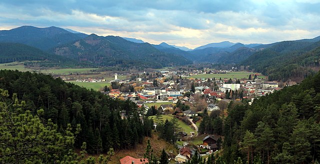
Гутенштайн (Gutenstein, Gutenstein)
- коммуна в Австрии
 Hiking in Гутенштайн
Gutenstein, located in the picturesque region of Lower Austria, is a great destination for hiking enthusiasts. The area is characterized by its stunning natural landscapes, rolling hills, dense forests, and diverse flora and fauna, making it a perfect spot for outdoor activities.
Hiking Trails
- Landschaftsschutzgebiet Gutenstein: This landscape protection area offers a variety of trails suitable for all hiking levels. The trails meander through lush forests and offer scenic views of the surrounding countryside.
- Wanderwege: There are marked hiking paths featuring varying degrees of difficulty, including shorter, family-friendly walks and more rigorous routes for experienced hikers. These paths often lead to viewpoints and natural landmarks.
- Burgruine Gutenstein: Hike up to the ruins of the Gutenstein Castle for a historical experience coupled with panoramic views of the surrounding area.
Nature and Scenery
The area around Gutenstein is rich in biodiversity, featuring a mix of beech and fir forests, meadows, and rocky outcrops. Birdwatchers and nature enthusiasts will appreciate the variety of species that inhabit the region.
Best Time to Hike
The ideal times for hiking in Gutenstein are late spring through early autumn (May to September) when the weather is mild, and the trails are generally dry and accessible. However, winter hikes are also possible, but be cautious of snow and icy conditions.
Tips for Hikers
- Preparation: Ensure you have appropriate hiking gear, including sturdy footwear and weather-appropriate clothing.
- Navigation: Carry a map or use a hiking app, as some trails may not be well marked.
- Water and Snacks: Bring enough water and some snacks, especially for longer trails.
- Respect Nature: Follow Leave No Trace principles to keep the environment pristine.
Overall, hiking in Gutenstein provides a fantastic opportunity to explore the natural beauty and tranquility of Lower Austria.
- Страна:

- Телефонный код: 02634
- Код автомобильного номера: WB
- Координаты: 47° 52' 0" N, 15° 53' 0" E


- GPS треки (wikiloc): [Ссылка]
- Высота над уровнем моря: 481 м m
- Площадь: 104.2 кв.км
- Население: 1268
- Веб сайт: http://www.gutenstein.at/
- Википедия русская: wiki(ru)
- Википедия английская: wiki(en)
- Википедия национальная: wiki(de)
- Хранилище Wikidata: Wikidata: Q663658
- Катеория в википедии: [Ссылка]
- код Freebase: [/m/0b_r7p]
- код GeoNames: Альт: [7873053]
- код VIAF: Альт: [246359650]
- идентификатор местоположения ArchINFORM: [6482]
- код австрийского муниципалитета: [32308]
Граничит с регионами:


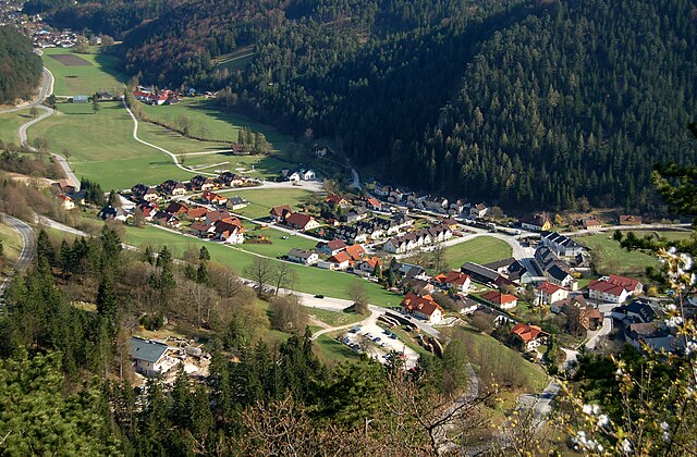
Вайдмансфельд
Hiking in Вайдмансфельд
Waidmannsfeld is a picturesque area located in Austria, known for its natural beauty and numerous hiking opportunities. Here’s an overview of what you might expect when hiking in Waidmannsfeld:...
- Страна:
- Телефонный код: 02632
- Код автомобильного номера: WB
- Координаты: 47° 52' 0" N, 15° 58' 0" E
- GPS треки (wikiloc): [Ссылка]
- Высота над уровнем моря: 495 м m
- Площадь: 21.39 кв.км
- Население: 1515
- Веб сайт: [Ссылка]

Пухберг-ам-Шнеберг
Hiking in Пухберг-ам-Шнеберг
Puchberg am Schneeberg is a charming village located in Lower Austria, surrounded by the scenic Beauty of the Schneeberg massif, which is the highest mountain in the Eastern Alps. Hiking in this area offers a range of experiences, from gentle walks to challenging climbs, making it suitable for hikers of all abilities....
- Страна:
- Телефонный код: 02636
- Код автомобильного номера: NK
- Координаты: 47° 47' 0" N, 15° 54' 0" E
- GPS треки (wikiloc): [Ссылка]
- Высота над уровнем моря: 585 м m
- Площадь: 83.17 кв.км
- Население: 2683
- Веб сайт: [Ссылка]

Шварцау-им-Гебирге
Hiking in Шварцау-им-Гебирге
Schwarzau im Gebirge is a charming village located in Austria, nestled within the picturesque landscape of the Semmering region. It's a fantastic destination for hiking enthusiasts, offering a variety of trails suitable for different skill levels....
- Страна:
- Почтовый код: 2661, 2662
- Телефонный код: 02667
- Код автомобильного номера: NK
- Координаты: 47° 48' 0" N, 15° 42' 0" E
- GPS треки (wikiloc): [Ссылка]
- Высота над уровнем моря: 618 м m
- Площадь: 190.44 кв.км
- Население: 644
- Веб сайт: [Ссылка]
Перниц
Hiking in Перниц
Pernitz is a charming village located in the Lower Austria region of Austria, surrounded by the picturesque landscapes of the Wienerwald (Vienna Woods). Hiking in Pernitz offers hikers a fantastic opportunity to explore stunning natural scenery, rich biodiversity, and historical sites, making it an excellent destination for outdoor enthusiasts....
- Страна:
- Телефонный код: 02632
- Код автомобильного номера: WB
- Координаты: 47° 54' 0" N, 15° 58' 0" E
- GPS треки (wikiloc): [Ссылка]
- Высота над уровнем моря: 430 м m
- Площадь: 16.59 кв.км
- Население: 2473
- Веб сайт: [Ссылка]

Муггендорф
Hiking in Муггендорф
Muggendorf, located in the scenic region of Lower Austria, is known for its beautiful landscapes and rich natural diversity, making it a fantastic destination for hikers. Situated near the Vienna Woods, the area offers a variety of trails suitable for different skill levels. Here are some highlights of hiking in Muggendorf:...
- Страна:
- Почтовый код: 2763
- Телефонный код: 02632
- Код автомобильного номера: WB
- Координаты: 47° 54' 0" N, 15° 56' 0" E
- GPS треки (wikiloc): [Ссылка]
- Высота над уровнем моря: 450 м m
- Площадь: 50.93 кв.км
- Население: 528
- Веб сайт: [Ссылка]

Мизенбах
Hiking in Мизенбах
Miesenbach, a small village located in Lower Austria, is surrounded by beautiful landscapes and offers a variety of hiking opportunities that appeal to outdoor enthusiasts. Here are some highlights of hiking in the Miesenbach area:...
- Страна:
- Почтовый код: 2761
- Телефонный код: 02632
- Код автомобильного номера: WB
- Координаты: 47° 50' 0" N, 15° 59' 0" E
- GPS треки (wikiloc): [Ссылка]
- Высота над уровнем моря: 470 м m
- Площадь: 34.13 кв.км
- Население: 703
- Веб сайт: [Ссылка]

Rohr im Gebirge
Hiking in Rohr im Gebirge
Rohr im Gebirge is a picturesque area located in Lower Austria, known for its scenic landscapes and charming natural surroundings. While it may not be as widely recognized as some of Austria's larger hiking destinations, it offers a range of trails suitable for various skill levels amidst beautiful countryside....
- Страна:
- Почтовый код: 2663
- Телефонный код: 02667
- Код автомобильного номера: WB
- Координаты: 47° 52' 0" N, 15° 43' 0" E
- GPS треки (wikiloc): [Ссылка]
- Высота над уровнем моря: 683 м m
- Площадь: 80.6 кв.км
- Население: 476
- Веб сайт: [Ссылка]