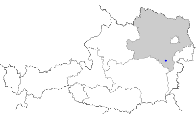
Пухберг-ам-Шнеберг (Puchberg am Schneeberg, Puchberg am Schneeberg)
 Hiking in Пухберг-ам-Шнеберг
Puchberg am Schneeberg is a charming village located in Lower Austria, surrounded by the scenic Beauty of the Schneeberg massif, which is the highest mountain in the Eastern Alps. Hiking in this area offers a range of experiences, from gentle walks to challenging climbs, making it suitable for hikers of all abilities.
Popular Hiking Trails:
-
Schneeberg Summit Trail (Schneeberg Gipfelweg):
- This is the most popular hiking route that leads you to the summit of Schneeberg (2,076 m). The trail is well-marked and offers stunning panoramic views as you ascend. It’s a challenging hike that requires a good level of fitness.
-
Kaiserhaus:
- A well-known destination on Schneeberg, the trail to Kaiserhaus can be started from the Puchberg base or via the Schneebergbahn cog railway. This route is moderately difficult and provides beautiful views along the way.
-
Mariazeller Weg:
- This long-distance trail runs through the area and connects to the famous pilgrimage route to Mariazell. It features diverse landscapes and is ideal for those looking for a multi-day hiking experience.
-
Schneeberger Schutzhaus:
- This is a popular refuge for hikers on their way to the summit. The trail to the Schutzhaus offers various options for shorter hikes with remarkable views, perfect for families or less experienced hikers.
Seasonal Considerations:
- Summer: The summer months are ideal for hiking, with a wide range of flowers blooming and the weather being generally warm.
- Autumn: Fall brings beautiful foliage, but it's important to dress in layers as temperatures can change rapidly.
- Winter: While some trails are accessible, certain routes may require winter hiking gear, like crampons or snowshoes. The Schneeberg area is also popular for skiing.
Tips for Hiking in Puchberg am Schneeberg:
- Weather: Always check the weather forecast before heading out, as conditions can change quickly in mountainous areas.
- Navigation: Use a good map or a hiking app to stay on designated trails and ensure safe navigation.
- What to Bring: Be sure to bring plenty of water, snacks, appropriate hiking footwear, and a first-aid kit. Although there are mountain huts, it’s wise to carry your own supplies, especially for longer hikes.
- Wildlife and Nature: Respect the local wildlife by not feeding animals and staying on the trails to protect the natural environment.
Getting There:
Puchberg am Schneeberg is easily accessible by train or car from Vienna and other surrounding areas, making it a great destination for a day trip or weekend getaway for hiking enthusiasts.
Whether you're an experienced hiker or a beginner, Puchberg am Schneeberg offers a rewarding hiking experience in the heart of nature.
- Страна:

- Телефонный код: 02636
- Код автомобильного номера: NK
- Координаты: 47° 47' 0" N, 15° 54' 0" E


- GPS треки (wikiloc): [Ссылка]
- Высота над уровнем моря: 585 м m
- Площадь: 83.17 кв.км
- Население: 2683
- Веб сайт: http://www.puchberg.at/
- Википедия русская: wiki(ru)
- Википедия английская: wiki(en)
- Википедия национальная: wiki(de)
- Хранилище Wikidata: Wikidata: Q666478
- Катеория в википедии: [Ссылка]
- код Freebase: [/m/04ywq2]
- код GeoNames: Альт: [7872995]
- код VIAF: Альт: [238105476]
- идентификатор местоположения ArchINFORM: [10696]
- код LCNAF: Альт: [n98083800]
- место в MusicBrainz: [91d6f000-1e47-4675-8119-098879c167ab]
- WOEID: [12673853]
- код австрийского муниципалитета: [31826]
Граничит с регионами:

Терниц
- город в Федеральной земле Нижняя Австрия
Hiking in Терниц
Ternitz, located in Lower Austria, offers a variety of hiking opportunities that cater to different skill levels. The region is characterized by its beautiful landscapes, rolling hills, and lush forests, providing a scenic backdrop for outdoor enthusiasts....
- Страна:
- Почтовый код: 2620, 2630, 2631, 2632, 2732, 2733, 2734
- Телефонный код: 02630
- Код автомобильного номера: NK
- Координаты: 47° 43' 0" N, 16° 2' 0" E
- GPS треки (wikiloc): [Ссылка]
- Высота над уровнем моря: 393 м m
- Площадь: 65.35 кв.км
- Население: 14632
- Веб сайт: [Ссылка]

Гутенштайн
- коммуна в Австрии
Hiking in Гутенштайн
Gutenstein, located in the picturesque region of Lower Austria, is a great destination for hiking enthusiasts. The area is characterized by its stunning natural landscapes, rolling hills, dense forests, and diverse flora and fauna, making it a perfect spot for outdoor activities....
- Страна:
- Телефонный код: 02634
- Код автомобильного номера: WB
- Координаты: 47° 52' 0" N, 15° 53' 0" E
- GPS треки (wikiloc): [Ссылка]
- Высота над уровнем моря: 481 м m
- Площадь: 104.2 кв.км
- Население: 1268
- Веб сайт: [Ссылка]

Райхенау-ан-дер-Ракс
- ярмарочная коммуна в земле Нижняя Австрия
Hiking in Райхенау-ан-дер-Ракс
Reichenau an der Rax, located in Austria, is a stunning destination for hiking enthusiasts, offering a variety of trails that cater to different skill levels and preferences. Nestled in the Rax-Schneeberg region, Reichenau provides breathtaking views of the surrounding mountains and valleys, making it a popular spot for both casual walkers and seasoned hikers....
- Страна:
- Почтовый код: 2651, 2654
- Телефонный код: 02666
- Код автомобильного номера: NK
- Координаты: 47° 42' 0" N, 15° 50' 0" E
- GPS треки (wikiloc): [Ссылка]
- Высота над уровнем моря: 484 м m
- Площадь: 89.5 кв.км
- Население: 2601
- Веб сайт: [Ссылка]

Шварцау-им-Гебирге
Hiking in Шварцау-им-Гебирге
Schwarzau im Gebirge is a charming village located in Austria, nestled within the picturesque landscape of the Semmering region. It's a fantastic destination for hiking enthusiasts, offering a variety of trails suitable for different skill levels....
- Страна:
- Почтовый код: 2661, 2662
- Телефонный код: 02667
- Код автомобильного номера: NK
- Координаты: 47° 48' 0" N, 15° 42' 0" E
- GPS треки (wikiloc): [Ссылка]
- Высота над уровнем моря: 618 м m
- Площадь: 190.44 кв.км
- Население: 644
- Веб сайт: [Ссылка]
Бюрг-Фёстенхоф
Hiking in Бюрг-Фёстенхоф
Bürg-Vöstenhof is a charming area located in Germany, well-known for its picturesque landscapes and outdoor recreation opportunities, including hiking. The region typically features a variety of marked trails that cater to different skill levels, making it accessible for both novice hikers and seasoned trekkers....
- Страна:
- Почтовый код: 2630
- Телефонный код: 02630
- Код автомобильного номера: NK
- Координаты: 47° 43' 0" N, 15° 58' 0" E
- GPS треки (wikiloc): [Ссылка]
- Высота над уровнем моря: 570 м m
- Площадь: 25.12 кв.км
- Население: 179
- Веб сайт: [Ссылка]
Шраттенбах
Hiking in Шраттенбах
Schrattenbach is a picturesque area located in Austria, known for its stunning landscapes and hiking opportunities. It’s often appreciated for its natural beauty, featuring a mix of forested areas, open meadows, and rocky terrain....
- Страна:
- Почтовый код: 2733
- Телефонный код: 02637
- Код автомобильного номера: NK
- Координаты: 47° 47' 0" N, 16° 0' 0" E
- GPS треки (wikiloc): [Ссылка]
- Высота над уровнем моря: 517 м m
- Площадь: 10.82 кв.км
- Население: 363
- Веб сайт: [Ссылка]

Мизенбах
Hiking in Мизенбах
Miesenbach, a small village located in Lower Austria, is surrounded by beautiful landscapes and offers a variety of hiking opportunities that appeal to outdoor enthusiasts. Here are some highlights of hiking in the Miesenbach area:...
- Страна:
- Почтовый код: 2761
- Телефонный код: 02632
- Код автомобильного номера: WB
- Координаты: 47° 50' 0" N, 15° 59' 0" E
- GPS треки (wikiloc): [Ссылка]
- Высота над уровнем моря: 470 м m
- Площадь: 34.13 кв.км
- Население: 703
- Веб сайт: [Ссылка]

Грюнбах-ам-Шнеберг
Hiking in Грюнбах-ам-Шнеберг
Grünbach am Schneeberg is a picturesque village located in the Lower Austrian region, nestled near the Schneeberg mountain, which is one of the most sought-after hiking destinations in the area. Here’s what you can expect when hiking around Grünbach am Schneeberg:...
- Страна:
- Почтовый код: 2733
- Телефонный код: 02637
- Код автомобильного номера: NK
- Координаты: 47° 47' 53" N, 15° 59' 13" E
- GPS треки (wikiloc): [Ссылка]
- Высота над уровнем моря: 557 м m
- Площадь: 7.37 кв.км
- Население: 1647
- Веб сайт: [Ссылка]