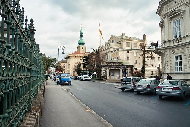
Хайлигенкройц (Heiligenkreuz, Lower Austria, Heiligenkreuz)

 Hiking in Хайлигенкройц
Heiligenkreuz, located in Lower Austria, is a picturesque area that offers some fantastic hiking opportunities, appealing to both beginners and experienced hikers. Nestled in the Vienna Woods (Wienerwald), Heiligenkreuz is renowned for its natural beauty, historical sites, and well-marked trails.
Popular Hiking Trails
-
Heiligenkreuz Monastery Trail: This trail takes you past the historical Heiligenkreuz Abbey, one of the most important Cistercian monasteries in the region. The trail is relatively easy and allows hikers to enjoy the beautiful architecture of the abbey along with the surrounding forest.
-
Kahlenberg and Leopoldsberg: While a bit further from Heiligenkreuz, these trails are famous among hikers for the panoramic views of Vienna and the Danube. They offer varied terrain and can be combined with a trek through the Vienna Woods.
-
Rundweg Heiligenkreuz: This loop trail takes you through beautiful landscapes with a mixture of forests and meadows. It is well-suited for families and can offer a relaxed hiking experience.
-
Schwarzsee and Hinterbrühl: Exploring further into the region, this trail leads to the scenic Schwarzsee (Black Lake), offering a tranquil place to rest. The area provides a blend of natural beauty and tranquility, perfect for a day hike.
Tips for Hiking in Heiligenkreuz
-
Best Time to Visit: The most pleasant hiking conditions are typically from late spring to early autumn when the weather is mild, and the flora is in full bloom.
-
Trail Markings: Trails in the area are usually well-marked. Look for the signs indicating the direction and difficulty level of the trails.
-
Preparation: Always carry sufficient water, snacks, a map or GPS, and wear appropriate hiking shoes. Weather can change quickly, so dress in layers.
-
Respect Nature: As always, practice Leave No Trace principles; stick to marked trails to protect the local environment.
-
Combine with Culture: After hiking, take some time to explore the cultural heritage of Heiligenkreuz, including the abbey, offering beautiful architecture and a peaceful atmosphere.
Getting There
Heiligenkreuz is easily accessible by car or public transport from Vienna, making it an excellent option for a day trip. Various bus lines connect the village to Vienna and nearby towns.
Whether you're looking for a short nature walk or a longer hike immersed in the stunning scenery of Lower Austria, Heiligenkreuz presents a delightful and enriching hiking experience!
- Страна:

- Телефонный код: 02258
- Код автомобильного номера: BN
- Координаты: 48° 3' 23" N, 16° 7' 45" E


- GPS треки (wikiloc): [Ссылка]
- Высота над уровнем моря: 312 м m
- Площадь: 29.5 кв.км
- Население: 1525
- Веб сайт: http://www.heiligenkreuz.at
- Википедия русская: wiki(ru)
- Википедия английская: wiki(en)
- Википедия национальная: wiki(de)
- Хранилище Wikidata: Wikidata: Q665159
- Галерея изображений в википедии: [Ссылка]
- Катеория в википедии: [Ссылка]
- код Freebase: [/m/02qssb6]
- код GeoNames: Альт: [7871707]
- идентификатор местоположения ArchINFORM: [5696]
- код LCNAF: Альт: [nr88006974]
- код австрийского муниципалитета: [30613]
- код Цифрового атласа Римской империи: [42803]
Граничит с регионами:
Баден
- бальнеолечебница в Австрии, Нижняя Австрия, Баден
Hiking in Баден
Baden bei Wien is a lovely spa town located just south of Vienna, Austria, known for its natural beauty and numerous hiking opportunities. The area combines picturesque landscapes, historical sites, and the famous vineyards of the region, making it a great destination for hikers of all skill levels....
- Страна:
- Почтовый код: 2502; 2500
- Телефонный код: 02252
- Код автомобильного номера: BN
- Координаты: 48° 0' 27" N, 16° 14' 4" E
- GPS треки (wikiloc): [Ссылка]
- Высота над уровнем моря: 230 м m
- Площадь: 26.89 кв.км
- Население: 26286
- Веб сайт: [Ссылка]

Алланд
Hiking in Алланд
Alland is a beautiful area located in the Lower Austria region, known for its picturesque landscapes, rolling hills, and lush forests. Hiking in Alland offers a wonderful opportunity to enjoy nature, discover local flora and fauna, and experience the tranquility of the outdoors....
- Страна:
- Почтовый код: 2565; 2534; 2533; 2532; 2500
- Телефонный код: 02258
- Код автомобильного номера: BN
- Координаты: 48° 3' 30" N, 16° 4' 50" E
- GPS треки (wikiloc): [Ссылка]
- Высота над уровнем моря: 331 м m
- Площадь: 68.71 кв.км
- Население: 2622
- Веб сайт: [Ссылка]
Пфафштеттен
Hiking in Пфафштеттен
Pfaffstätten is a charming village located in Lower Austria, near the wine-growing region of the Thermenregion. This area is known for its beautiful landscapes, rolling hills, and scenic vineyards, making it a wonderful destination for hiking enthusiasts. Here are some highlights and tips for hiking in and around Pfaffstätten:...
- Страна:
- Почтовый код: 2511
- Телефонный код: 02252
- Код автомобильного номера: BN
- Координаты: 48° 1' 0" N, 16° 15' 58" E
- GPS треки (wikiloc): [Ссылка]
- Высота над уровнем моря: 218 м m
- Площадь: 7.81 кв.км
- Население: 3551
- Веб сайт: [Ссылка]


Гаден
- коммуна в Австрии, в федеральной земле Нижняя Австрия
Hiking in Гаден
Gaaden is a small village located in Austria, near the scenic region of the Wienerwald (Vienna Woods). While it may not be as widely known as larger hiking destinations, it offers several opportunities for outdoor enthusiasts looking for scenic trails and a peaceful environment....
- Страна:
- Почтовый код: 2531
- Телефонный код: 02237
- Код автомобильного номера: MD
- Координаты: 48° 3' 0" N, 16° 12' 0" E
- GPS треки (wikiloc): [Ссылка]
- Высота над уровнем моря: 323 м m
- Площадь: 24.78 кв.км
- Население: 1624
- Веб сайт: [Ссылка]
Винервальд
Hiking in Винервальд
Wienerwald, or the Vienna Woods, is a beautiful and expansive forested area located just west of Vienna, Austria. It is part of the Northern Limestone Alps and offers numerous hiking opportunities for outdoor enthusiasts of all skill levels. Here are some aspects of hiking in Wienerwald:...
- Страна:
- Почтовый код: 2392
- Телефонный код: 02238
- Код автомобильного номера: MD
- Координаты: 48° 6' 0" N, 16° 8' 0" E
- GPS треки (wikiloc): [Ссылка]
- Высота над уровнем моря: 649 м m
- Площадь: 48.16 кв.км
- Население: 2858
- Веб сайт: [Ссылка]