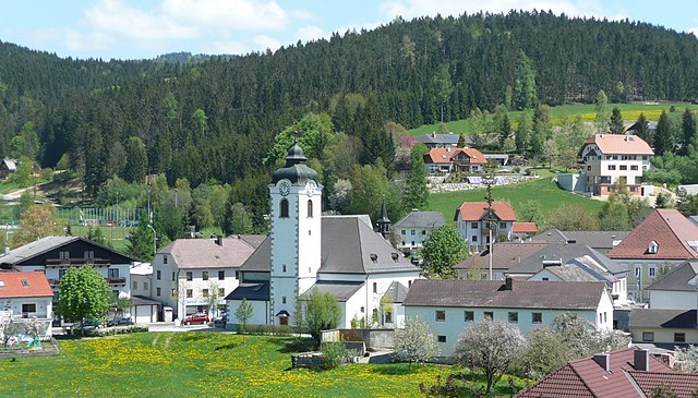
Хельфенберг (Helfenberg, Helfenberg)
- коммуна в федеральной земле Верхняя Австрия, Австрия
 Hiking in Хельфенберг
Helfenberg, a quaint area nestled in Austria, offers various hiking opportunities suited for different skill levels and interests. The natural beauty surrounding Helfenberg features lush landscapes, rolling hills, and stunning views, making it a great destination for outdoor enthusiasts.
Popular Hiking Trails
-
Helfenberg Panorama Trail: This trail offers breathtaking views of the surrounding countryside and is perfect for those looking to enjoy a leisurely hike. The route typically features well-marked paths and takes you through picturesque meadows and forests.
-
Forest Trails: Several trails wind through the dense forests around Helfenberg. These paths allow hikers to immerse themselves in nature, perfect for birdwatching and enjoying the tranquility of the woods.
-
Mountain Routes: For more experienced hikers, routes that lead to higher elevations can be found in the nearby hills and mountains. These trails often provide stunning vistas and may include more challenging terrain.
Tips for Hiking in Helfenberg
- Gear Up: Ensure you wear sturdy hiking boots and bring appropriate clothing layers, as weather can change quickly in the mountains.
- Maps and Info: Check local maps and visitor centers for updated trail information, as conditions can vary.
- Stay Hydrated: Carry enough water, especially on longer hikes, and consider packing snacks for energy boosts.
- Wildlife Awareness: Be mindful of local wildlife and observe from a distance to respect their habitat.
- Leave No Trace: Follow Leave No Trace principles to preserve the natural beauty for future hikers.
Local Attractions and Amenities
- Cafés and Restaurants: After a day of hiking, enjoy local cuisine in cafes and restaurants in Helfenberg to refuel.
- Cultural Sites: Take some time to explore historical landmarks in the area, adding a cultural touch to your outdoor adventure.
Whether you’re an experienced hiker or just looking for a pleasant walk in nature, Helfenberg has something to offer. Always check local resources for the latest trail conditions and safety advisories before heading out. Happy hiking!
- Страна:

- Почтовый код: 4184
- Телефонный код: 0 72 16
- Код автомобильного номера: RO
- Координаты: 48° 32' 36" N, 14° 8' 33" E


- GPS треки (wikiloc): [Ссылка]
- Высота над уровнем моря: 567 м m
- Площадь: 22.67 кв.км
- Население: 1004
- Веб сайт: http://www.helfenberg.at/
- Википедия русская: wiki(ru)
- Википедия английская: wiki(en)
- Википедия национальная: wiki(de)
- Хранилище Wikidata: Wikidata: Q679532
- Катеория в википедии: [Ссылка]
- код Freebase: [/m/03gv9lw]
- код GeoNames: Альт: [2776536]
- код GND: Альт: [4697638-3]
- код австрийского муниципалитета: [41345]
Граничит с регионами:
Санкт-Файт
- община в Австрии, Верхняя Австрия, Рорбах
Hiking in Санкт-Файт
Sankt Veit im Mühlkreis, located in the Upper Austria region, is a picturesque area well-suited for hiking enthusiasts. Nestled in the foothills of the Alps, it offers a variety of trails that cater to different skill levels and provide stunning views of the surrounding countryside and the Mühlviertel region....
- Страна:
- Почтовый код: 4173
- Телефонный код: 07217
- Код автомобильного номера: RO
- Координаты: 48° 28' 16" N, 14° 9' 53" E
- GPS треки (wikiloc): [Ссылка]
- Высота над уровнем моря: 686 м m
- Площадь: 16 кв.км
- Население: 1206
- Веб сайт: [Ссылка]
St. Stefan-Afiesl
Hiking in St. Stefan-Afiesl
St. Stefan-Afiesl is a picturesque village located in the beautiful region of Styria in Austria. It offers a variety of hiking opportunities that cater to different skill levels and preferences. Here’s what you can expect from hiking in and around St. Stefan-Afiesl:...
- Страна:
- Координаты: 48° 34' 0" N, 14° 6' 0" E
- GPS треки (wikiloc): [Ссылка]
- Высота над уровнем моря: 740 м m
- Площадь: 29.58 кв.км
- Население: 1198
Фордервайссенбах
Hiking in Фордервайссенбах
Vorderweißenbach is a picturesque area located in the Mühlviertel region of Austria, known for its beautiful landscapes, rolling hills, and dense forests. Here is an overview of what you can expect when hiking in and around Vorderweißenbach:...
- Страна:
- Почтовый код: 4191
- Телефонный код: 07219
- Код автомобильного номера: UU
- Координаты: 48° 33' 10" N, 14° 13' 12" E
- GPS треки (wikiloc): [Ссылка]
- Высота над уровнем моря: 705 м m
- Площадь: 63.48 кв.км
- Население: 2653
- Веб сайт: [Ссылка]
Обернойкирхен
Hiking in Обернойкирхен
Oberneukirchen, located in the picturesque region of Upper Austria, offers a variety of hiking opportunities amidst beautiful natural landscapes. The area is known for its charming countryside, rolling hills, and the scenic backdrop of the Alpine foothills. Here are some highlights to consider when hiking in and around Oberneukirchen:...
- Страна:
- Почтовый код: 4181
- Телефонный код: 07212
- Код автомобильного номера: UU
- Координаты: 48° 27' 53" N, 14° 13' 38" E
- GPS треки (wikiloc): [Ссылка]
- Высота над уровнем моря: 774 м m
- Площадь: 34.55 кв.км
- Население: 3202
- Веб сайт: [Ссылка]

Санкт-Петер-на-Вимберге
Hiking in Санкт-Петер-на-Вимберге
Sankt Peter am Wimberg is a picturesque village located in the Mühlviertel region of Austria. It's an excellent starting point for various hiking adventures, offering a mix of serene landscapes, lush forests, and beautiful views of the surrounding countryside....
- Страна:
- Почтовый код: 4171
- Телефонный код: 07282
- Код автомобильного номера: RO
- Координаты: 48° 30' 10" N, 14° 5' 12" E
- GPS треки (wikiloc): [Ссылка]
- Высота над уровнем моря: 668 м m
- Площадь: 23 кв.км
- Население: 1770
- Веб сайт: [Ссылка]

Санкт-Йохан-на-Вимберге
Hiking in Санкт-Йохан-на-Вимберге
Sankt Johann am Wimberg is a picturesque village located in Austria's Upper Austria region. It's an excellent destination for hiking enthusiasts, offering a variety of trails that cater to different skill levels and preferences....
- Страна:
- Почтовый код: 4172
- Телефонный код: 07217
- Код автомобильного номера: RO
- Координаты: 48° 29' 19" N, 14° 7' 51" E
- GPS треки (wikiloc): [Ссылка]
- Высота над уровнем моря: 720 м m
- Площадь: 19.77 кв.км
- Население: 1029
- Веб сайт: [Ссылка]