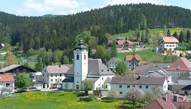
Обернойкирхен (Oberneukirchen, Oberneukirchen)
 Hiking in Обернойкирхен
Oberneukirchen, located in the picturesque region of Upper Austria, offers a variety of hiking opportunities amidst beautiful natural landscapes. The area is known for its charming countryside, rolling hills, and the scenic backdrop of the Alpine foothills. Here are some highlights to consider when hiking in and around Oberneukirchen:
Trails and Routes
-
Local Hiking Trails: There are several well-marked trails that cater to various skill levels. Many of these trails pass through lush forests, meadows, and past small streams, providing a tranquil hiking experience.
-
Regional Networks: Oberneukirchen connects to the larger network of trails in the Mühlviertel region. You can explore longer routes that take you through charming villages and historical sites.
-
Nature Reserves: Nearby nature reserves often feature trails that allow hikers to appreciate local flora and fauna, making it an excellent spot for nature enthusiasts.
Terrain and Difficulty
- The terrain around Oberneukirchen varies from easy, flat paths suitable for families to more challenging hikes in the surrounding hills. Most trails are well-maintained, making them accessible to a wide range of hikers.
Best Season to Hike
- Spring and Autumn: These seasons offer mild weather and beautiful scenery, as flowers bloom in spring and foliage changes in autumn.
- Summer: Ideal for hiking, though be prepared for heat and carry enough water.
- Winter: While most hikes may not be accessible, some trails are suitable for snowshoeing or winter hiking, providing a different perspective of the landscape.
Amenities
- Accommodations: Oberneukirchen has various options for lodging, from hotels to guesthouses, making it convenient for multi-day hikes.
- Local Food: Don’t miss trying local Austrian cuisine at nearby restaurants or inns, which can make for a great post-hike experience.
Safety Tips
- Weather Conditions: Always check the weather forecast before heading out.
- Gear: Wear appropriate footwear and carry sufficient supplies, including water, snacks, and a first-aid kit.
- Regulations: Follow local regulations and trail markings to help preserve the natural environment.
Conclusion
Hiking in Oberneukirchen provides a wonderful mix of tranquility, rich nature, and local culture. Whether you're looking for a leisurely walk or a more challenging hike, there's something for everyone in this beautiful part of Austria. Always remember to leave no trace and enjoy the stunning surroundings!
- Страна:

- Почтовый код: 4181
- Телефонный код: 07212
- Код автомобильного номера: UU
- Координаты: 48° 27' 53" N, 14° 13' 38" E


- GPS треки (wikiloc): [Ссылка]
- Высота над уровнем моря: 774 м m
- Площадь: 34.55 кв.км
- Население: 3202
- Веб сайт: http://www.oberneukirchen.ooe.gv.at/
- Википедия русская: wiki(ru)
- Википедия английская: wiki(en)
- Википедия национальная: wiki(de)
- Хранилище Wikidata: Wikidata: Q681351
- Катеория в википедии: [Ссылка]
- код Freebase: [/m/03gvcxq]
- код GeoNames: Альт: [7872153]
- код VIAF: Альт: [159253171]
- идентификатор местоположения ArchINFORM: [6469]
- WOEID: [546195]
- код австрийского муниципалитета: [41615]
Граничит с регионами:

Цветтль-на-Родле
Hiking in Цветтль-на-Родле
Zwettl an der Rodl is a picturesque village located in Upper Austria, known for its beautiful landscapes and outdoor activities, making it a great spot for hiking enthusiasts. The region features a mix of hilly terrain, dense forests, and scenic views of the surrounding countryside....
- Страна:
- Почтовый код: 4180
- Телефонный код: 07212
- Код автомобильного номера: UU
- Координаты: 48° 28' 0" N, 14° 16' 2" E
- GPS треки (wikiloc): [Ссылка]
- Высота над уровнем моря: 616 м m
- Площадь: 15.36 кв.км
- Население: 1752
- Веб сайт: [Ссылка]
Санкт-Файт
- община в Австрии, Верхняя Австрия, Рорбах
Hiking in Санкт-Файт
Sankt Veit im Mühlkreis, located in the Upper Austria region, is a picturesque area well-suited for hiking enthusiasts. Nestled in the foothills of the Alps, it offers a variety of trails that cater to different skill levels and provide stunning views of the surrounding countryside and the Mühlviertel region....
- Страна:
- Почтовый код: 4173
- Телефонный код: 07217
- Код автомобильного номера: RO
- Координаты: 48° 28' 16" N, 14° 9' 53" E
- GPS треки (wikiloc): [Ссылка]
- Высота над уровнем моря: 686 м m
- Площадь: 16 кв.км
- Население: 1206
- Веб сайт: [Ссылка]

Бад-Леонфельден
Hiking in Бад-Леонфельден
Bad Leonfelden, located in the Mühlviertel region of Austria, is surrounded by picturesque landscapes that make it a great destination for hiking enthusiasts. The area is known for its rolling hills, lush forests, and scenic viewpoints. Here are some aspects to consider for hiking in Bad Leonfelden:...
- Страна:
- Почтовый код: 4190
- Телефонный код: 07213
- Код автомобильного номера: UU
- Координаты: 48° 31' 31" N, 14° 17' 36" E
- GPS треки (wikiloc): [Ссылка]
- Высота над уровнем моря: 750 м m
- Площадь: 40.33 кв.км
- Население: 4180
- Веб сайт: [Ссылка]

Айденберг
Hiking in Айденберг
Eidenberg, located in Austria, is a picturesque region offering various opportunities for hiking enthusiasts. The area is characterized by its beautiful landscapes, including rolling hills, lush forests, and stunning views of the surrounding nature....
- Страна:
- Почтовый код: 4201
- Код автомобильного номера: UU
- Координаты: 48° 23' 42" N, 14° 13' 51" E
- GPS треки (wikiloc): [Ссылка]
- Высота над уровнем моря: 685 м m
- Площадь: 29 кв.км
- Население: 2105
- Веб сайт: [Ссылка]
Фордервайссенбах
Hiking in Фордервайссенбах
Vorderweißenbach is a picturesque area located in the Mühlviertel region of Austria, known for its beautiful landscapes, rolling hills, and dense forests. Here is an overview of what you can expect when hiking in and around Vorderweißenbach:...
- Страна:
- Почтовый код: 4191
- Телефонный код: 07219
- Код автомобильного номера: UU
- Координаты: 48° 33' 10" N, 14° 13' 12" E
- GPS треки (wikiloc): [Ссылка]
- Высота над уровнем моря: 705 м m
- Площадь: 63.48 кв.км
- Население: 2653
- Веб сайт: [Ссылка]
Херцогсдорф
Hiking in Херцогсдорф
Herzogsdorf, located in Austria, is known for its picturesque landscapes and charming rural atmosphere. While it may not be as heavily trafficked as some larger hiking destinations, it offers a variety of trails that cater to different skill levels, making it a great spot for hiking enthusiasts....
- Страна:
- Почтовый код: 4175
- Телефонный код: 07231
- Код автомобильного номера: UU
- Координаты: 48° 25' 52" N, 14° 6' 49" E
- GPS треки (wikiloc): [Ссылка]
- Высота над уровнем моря: 591 м m
- Площадь: 35.39 кв.км
- Население: 2506
- Веб сайт: [Ссылка]

Хельфенберг
- коммуна в федеральной земле Верхняя Австрия, Австрия
Hiking in Хельфенберг
Helfenberg, a quaint area nestled in Austria, offers various hiking opportunities suited for different skill levels and interests. The natural beauty surrounding Helfenberg features lush landscapes, rolling hills, and stunning views, making it a great destination for outdoor enthusiasts....
- Страна:
- Почтовый код: 4184
- Телефонный код: 0 72 16
- Код автомобильного номера: RO
- Координаты: 48° 32' 36" N, 14° 8' 33" E
- GPS треки (wikiloc): [Ссылка]
- Высота над уровнем моря: 567 м m
- Площадь: 22.67 кв.км
- Население: 1004
- Веб сайт: [Ссылка]