Хинтеррайн (Hinterrhein, Hinterrhein)

 Hiking in Хинтеррайн
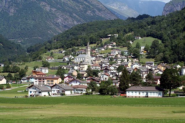
Hinterrhein, located in the canton of Graubünden, Switzerland, is a beautiful and relatively less-traveled region known for its stunning landscapes, diverse hiking trails, and rich cultural heritage. Here are some key points about hiking in Hinterrhein:
Natural Beauty
- Scenic Landscapes: Hinterrhein is characterized by dramatic mountain scenery, lush valleys, and crystal-clear rivers. The backdrop of the Swiss Alps provides breathtaking views throughout the hiking areas.
- Flora and Fauna: The region supports a wide range of Swiss flora and fauna, making it an excellent spot for nature enthusiasts and wildlife watchers.
Popular Hiking Trails
- Hinterrhein Valley Trail: This trail meanders along the Hinterrhein River, allowing hikers to enjoy both the river views and the surrounding hills. The terrain is varied, with opportunities for both easy strolls and more challenging hikes.
- Maloja Pass to the Rhine Gorge: A spectacular route that allows hikers to experience one of Switzerland's most impressive gorges, often referred to as the Grand Canyon of Switzerland. This is a more strenuous hike but rewards hikers with stunning vistas.
- Canton of Graubünden Trails: The region has a well-marked network of trails offering various levels of difficulty. There are options for day hikes as well as longer multi-day treks.
Hiking Conditions
- Seasonal Considerations: Hiking is popular in the warmer months (late spring to early autumn). During winter, snow can cover many trails, which may limit access but opens opportunities for snowshoeing and winter hiking in areas that are accessible.
- Preparation: It's essential to be prepared with appropriate gear for hiking, including proper footwear, weather-appropriate clothing, enough water, and food. Some trails may have rugged terrain, so it’s important to assess your fitness level and choose trails accordingly.
Access and Facilities
- Public Transport: Hinterrhein is accessible by public transport, including trains and buses from major cities in Switzerland. This makes it easy to start various hikes without needing a car.
- Accommodation: There are several options for accommodation in and around Hinterrhein, ranging from hotels and guesthouses to camping sites, offering a range of experiences for different budgets.
Tips for Hikers
- Check Weather Conditions: The weather can change rapidly in the mountains, so always check the forecast before heading out.
- Stay on Marked Trails: It’s vital to follow marked trails to minimize your impact on the environment and ensure your safety.
- Hiking Groups: If you're unsure about the trails or your ability, consider joining a guided hike or group to enhance safety and enjoyment.
Exploring Hinterrhein is a wonderful way to experience Switzerland's natural beauty, so lace up your hiking boots and enjoy the incredible scenery!
- Страна:

- Почтовый код: 7438
- Телефонный код: 081
- Код автомобильного номера: GR
- Координаты: 46° 31' 59" N, 9° 11' 59" E


- GPS треки (wikiloc): [Ссылка]
- Высота над уровнем моря: 2038 м m
- Площадь: 48.30 кв.км
- Население: 63
- Веб сайт: http://www.hinterrhein.ch
- Википедия русская: wiki(ru)
- Википедия английская: wiki(en)
- Википедия национальная: wiki(de)
- Хранилище Wikidata: Wikidata: Q64886
- Катеория в википедии: [Ссылка]
- код Freebase: [/m/026fypc]
- код GeoNames: Альт: [7286086]
- код VIAF: Альт: [236589814]
- ID отношения в OpenStreetMap: [1684089]
- идентификатор местоположения ArchINFORM: [5886]
- идентификатор HDS: [1496]
- код швейцарского муниципалитета: [3691]
Граничит с регионами:


Вальс
- община в кантоне Граубюнден, Швейцария
Hiking in Вальс
Vals, Switzerland, is a stunning hiking destination known for its picturesque landscapes, pristine nature, and serene environment. Nestled in the Swiss Alps, Vals offers a range of hiking trails suitable for all levels of hikers, from beginners to experienced trekkers. Here are some highlights of hiking in Vals:...
- Страна:
- Почтовый код: 7132
- Телефонный код: 081
- Код автомобильного номера: GR
- Координаты: 46° 36' 59" N, 9° 11' 0" E
- GPS треки (wikiloc): [Ссылка]
- Высота над уровнем моря: 1252 м m
- Площадь: 152.73 кв.км
- Население: 1050
- Веб сайт: [Ссылка]


Мезокко
Hiking in Мезокко
Mesocco, located in the picturesque Mendrisiotto region of southern Switzerland, offers a variety of hiking opportunities that cater to different skill levels and interests. Nestled in the valley of the Moesa River, this charming area is known for its stunning landscapes, historic villages, and lush nature....
- Страна:
- Почтовый код: 6563
- Телефонный код: 091
- Код автомобильного номера: GR
- Координаты: 46° 23' 29" N, 9° 14' 15" E
- GPS треки (wikiloc): [Ссылка]
- Высота над уровнем моря: 828 м m
- Площадь: 164.9 кв.км
- Население: 1374
- Веб сайт: [Ссылка]


Нуфенен
Hiking in Нуфенен
Nufenen, located in Switzerland near the border with Italy, is known for its stunning landscapes and various hiking opportunities. Here’s a guide to hiking in the Nufenen area:...
- Страна:
- Почтовый код: 7437
- Телефонный код: 081
- Код автомобильного номера: GR
- Координаты: 46° 32' 24" N, 9° 14' 19" E
- GPS треки (wikiloc): [Ссылка]
- Высота над уровнем моря: 1569 м m
- Площадь: 28.03 кв.км
- Население: 140
- Веб сайт: [Ссылка]

Blenio
Hiking in Blenio
Blenio Valley, located in the Ticino region of Switzerland, offers a variety of hiking opportunities set against the backdrop of breathtaking landscapes. Here are some key points about hiking in Blenio:...
- Страна:
- Почтовый код: 6717, 6718, 6719, 6720
- Телефонный код: 091
- Код автомобильного номера: TI
- Координаты: 46° 32' 0" N, 8° 57' 0" E
- GPS треки (wikiloc): [Ссылка]
- Высота над уровнем моря: 902 м m
- Площадь: 263.9 кв.км
- Население: 1826
- Веб сайт: [Ссылка]


Serravalle
Hiking in Serravalle
Serravalle, located in the southern part of Switzerland, is a beautiful area known for its stunning landscapes, rich flora and fauna, and a variety of hiking trails that cater to different skill levels. Here are some highlights you may find interesting if you're considering hiking in this region:...
- Страна:
- Почтовый код: 6713, 6714, 6721
- Телефонный код: 091
- Код автомобильного номера: TI
- Координаты: 46° 25' 0" N, 8° 59' 0" E
- GPS треки (wikiloc): [Ссылка]
- Высота над уровнем моря: 389 м m
- Площадь: 96.8 кв.км
- Население: 2071
- Веб сайт: [Ссылка]