
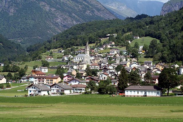
Вальс (Vals, Vals)

- община в кантоне Граубюнден, Швейцария
 Hiking in Вальс
Vals, Switzerland, is a stunning hiking destination known for its picturesque landscapes, pristine nature, and serene environment. Nestled in the Swiss Alps, Vals offers a range of hiking trails suitable for all levels of hikers, from beginners to experienced trekkers. Here are some highlights of hiking in Vals:
1.
The region is characterized by dramatic mountain scenery, including lush valleys, imposing peaks, and clear alpine lakes. The striking contrast between the green pastures and the rocky summits makes for breathtaking views.
2.
Vals has a variety of hiking trails:
- Easy Trails: Gentle paths like the hike to the Vals village trail, perfect for families and beginners.
- Moderate Trails: Trails that offer a bit more challenge, such as hikes leading to scenic viewpoints or nearby villages.
- Challenging Trails: For seasoned hikers, routes like the hike to the Piz Ault provide thrilling adventures with significant elevation gains and rugged paths.
3.
In addition to hiking, Vals is also famous for its natural hot springs. After a long day on the trails, you can relax and rejuvenate in the thermal baths, which are known for their healing properties.
4.
The area is rich in biodiversity, offering opportunities to observe various wildlife, including chamois, ibex, and different bird species. The flora is also diverse, with beautiful alpine flowers in the summer months.
5.
The region has a unique cultural heritage, including traditional Swiss architecture and historic sites. Exploring the villages and learning about local customs can enhance your hiking experience.
6.
The best time for hiking in Vals is generally from late spring to early autumn (May to October), when the weather is milder and trails are clear of snow. However, be cautious of weather changes, especially in higher elevations.
7.
- Always check weather conditions before heading out.
- Carry adequate supplies, including water, snacks, and a first aid kit.
- Make sure to have a good map or navigation tool.
- Inform someone about your hike plan, especially for longer or more challenging routes.
8.
Many of the trails can be accessed directly from the village of Vals, making it convenient for day hikes. Additionally, public transportation options are available for reaching more distant trailheads.
Whether you’re an avid hiker or just looking to enjoy the natural beauty of the Swiss Alps, Vals has something for everyone.
- Страна:

- Почтовый код: 7132
- Телефонный код: 081
- Код автомобильного номера: GR
- Координаты: 46° 36' 59" N, 9° 11' 0" E


- GPS треки (wikiloc): [Ссылка]
- Высота над уровнем моря: 1252 м m
- Площадь: 152.73 кв.км
- Население: 1050
- Веб сайт: http://www.vals.ch
- Википедия русская: wiki(ru)
- Википедия английская: wiki(en)
- Википедия национальная: wiki(de)
- Хранилище Wikidata: Wikidata: Q64585
- Катеория в википедии: [Ссылка]
- код Freebase: [/m/07c0cz]
- код GeoNames: Альт: [7287414]
- код BNF: [15242719v]
- код VIAF: Альт: [170526022]
- ID отношения в OpenStreetMap: [1684202]
- код GND: Альт: [4062315-4]
- идентификатор местоположения ArchINFORM: [1550]
- код темы Quora: [Vals]
- код SUDOC: [157647900]
- идентификатор HDS: [1461]
- код швейцарского муниципалитета: [3603]
Граничит с регионами:


Санкт-Мартин
- община в Швейцарии, Граубюнден
Hiking in Санкт-Мартин
Hiking in St. Martin, Graubünden, offers a beautiful experience within the Swiss Alps, characterized by stunning landscapes, diverse trails, and a rich cultural heritage. Here are some key points to consider when planning your hiking adventure in this picturesque region:...
- Страна:
- Почтовый код: 7116
- Телефонный код: 081
- Код автомобильного номера: GR
- Координаты: 46° 39' 59" N, 9° 9' 59" E
- GPS треки (wikiloc): [Ссылка]
- Высота над уровнем моря: 1003 м m
- Площадь: 22.83 кв.км
- Веб сайт: [Ссылка]


Хинтеррайн
Hiking in Хинтеррайн
Hinterrhein, located in the canton of Graubünden, Switzerland, is a beautiful and relatively less-traveled region known for its stunning landscapes, diverse hiking trails, and rich cultural heritage. Here are some key points about hiking in Hinterrhein:...
- Страна:
- Почтовый код: 7438
- Телефонный код: 081
- Код автомобильного номера: GR
- Координаты: 46° 31' 59" N, 9° 11' 59" E
- GPS треки (wikiloc): [Ссылка]
- Высота над уровнем моря: 2038 м m
- Площадь: 48.30 кв.км
- Население: 63
- Веб сайт: [Ссылка]


Нуфенен
Hiking in Нуфенен
Nufenen, located in Switzerland near the border with Italy, is known for its stunning landscapes and various hiking opportunities. Here’s a guide to hiking in the Nufenen area:...
- Страна:
- Почтовый код: 7437
- Телефонный код: 081
- Код автомобильного номера: GR
- Координаты: 46° 32' 24" N, 9° 14' 19" E
- GPS треки (wikiloc): [Ссылка]
- Высота над уровнем моря: 1569 м m
- Площадь: 28.03 кв.км
- Население: 140
- Веб сайт: [Ссылка]

Blenio
Hiking in Blenio
Blenio Valley, located in the Ticino region of Switzerland, offers a variety of hiking opportunities set against the backdrop of breathtaking landscapes. Here are some key points about hiking in Blenio:...
- Страна:
- Почтовый код: 6717, 6718, 6719, 6720
- Телефонный код: 091
- Код автомобильного номера: TI
- Координаты: 46° 32' 0" N, 8° 57' 0" E
- GPS треки (wikiloc): [Ссылка]
- Высота над уровнем моря: 902 м m
- Площадь: 263.9 кв.км
- Население: 1826
- Веб сайт: [Ссылка]