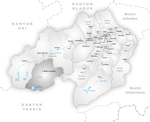
Blenio (Blenio)

 Hiking in Blenio
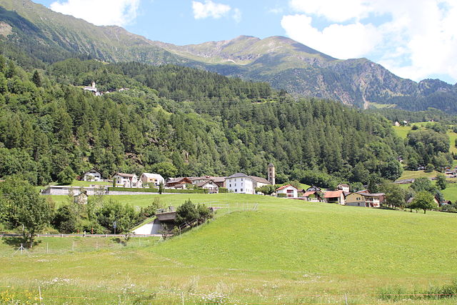
Blenio Valley, located in the Ticino region of Switzerland, offers a variety of hiking opportunities set against the backdrop of breathtaking landscapes. Here are some key points about hiking in Blenio:
Scenic Beauty
- Stunning Landscapes: Blenio is known for its diverse landscapes, including lush valleys, rugged mountains, and crystal-clear streams. The area is perfect for nature lovers and photographers.
- Flora and Fauna: As you hike, you may encounter a wide range of plants and wildlife unique to the region, making it an excellent spot for nature observation.
Hiking Trails
- Varied Difficulty Levels: The trails in Blenio cater to all levels of hikers, from easy walks suitable for families to challenging alpine routes for experienced adventurers.
- Popular Routes:
- Blenio to Acquarossa: This moderately challenging hike allows you to enjoy local flora and provides insights into the region's culture and history.
- Piz Bazio: A more strenuous hike that rewards you with panoramic views from the summit, ideal for seasoned hikers.
- Sentiero del Sole: This scenic route offers an overview of the valley and showcases amazing vistas and the chance to visit historical sites along the way.
Essentials for Hiking
- Weather Considerations: Check the weather conditions before heading out, as mountain weather can change rapidly. Summer is the best time for hiking, though late spring and early autumn are also pleasant.
- Gear: Appropriate footwear, weather-appropriate clothing, and plenty of water and snacks are essential. A hiking pole can also be helpful on some of the steeper trails.
- Navigation: While many trails are well-marked, carrying a map or a GPS device is advisable, particularly on less traveled paths.
Cultural Aspects
- Local Cuisine: Don't miss the opportunity to enjoy traditional Ticinese dishes in local restaurants or alpine huts along some of the trails.
- Historical Sites: Explore historical villages and churches along your hike; Blenio is rich in culture, and many trails lead you past beautiful old stone structures.
Accessibility
- Transport: Blenio Valley is accessible by public transport, making it easy to reach the trailheads without needing a car.
Safety Tips
- Always inform someone about your hiking plans, especially if venturing on less populated trails.
- Be aware of wildlife and practice respectful hiking; maintaining a safe distance from animals is crucial.
- Stay on marked trails to protect the local environment and avoid getting lost.
Enjoy your hiking adventure in Blenio Valley and immerse yourself in the stunning natural beauty and rich cultural heritage!
- Страна:

- Почтовый код: 6717, 6718, 6719, 6720
- Телефонный код: 091
- Код автомобильного номера: TI
- Координаты: 46° 32' 0" N, 8° 57' 0" E


- GPS треки (wikiloc): [Ссылка]
- Высота над уровнем моря: 902 м m
- Площадь: 263.9 кв.км
- Население: 1826
- Веб сайт: http://www.comuneblenio.ch/
- Википедия английская: wiki(en)
- Википедия национальная: wiki(de)
- Хранилище Wikidata: Wikidata: Q68789
- Катеория в википедии: [Ссылка]
- код Freebase: [/m/03hf_9y]
- код GeoNames: Альт: [7285270]
- код VIAF: Альт: [254611890]
- ID отношения в OpenStreetMap: [1684630]
- идентификатор местоположения ArchINFORM: [44923]
- идентификатор HDS: [8541]
- код швейцарского муниципалитета: [5049]
Граничит с регионами:


Вальс
- община в кантоне Граубюнден, Швейцария
Hiking in Вальс
Vals, Switzerland, is a stunning hiking destination known for its picturesque landscapes, pristine nature, and serene environment. Nestled in the Swiss Alps, Vals offers a range of hiking trails suitable for all levels of hikers, from beginners to experienced trekkers. Here are some highlights of hiking in Vals:...
- Страна:
- Почтовый код: 7132
- Телефонный код: 081
- Код автомобильного номера: GR
- Координаты: 46° 36' 59" N, 9° 11' 0" E
- GPS треки (wikiloc): [Ссылка]
- Высота над уровнем моря: 1252 м m
- Площадь: 152.73 кв.км
- Население: 1050
- Веб сайт: [Ссылка]


Хинтеррайн
Hiking in Хинтеррайн
Hinterrhein, located in the canton of Graubünden, Switzerland, is a beautiful and relatively less-traveled region known for its stunning landscapes, diverse hiking trails, and rich cultural heritage. Here are some key points about hiking in Hinterrhein:...
- Страна:
- Почтовый код: 7438
- Телефонный код: 081
- Код автомобильного номера: GR
- Координаты: 46° 31' 59" N, 9° 11' 59" E
- GPS треки (wikiloc): [Ссылка]
- Высота над уровнем моря: 2038 м m
- Площадь: 48.30 кв.км
- Население: 63
- Веб сайт: [Ссылка]

Медель
Hiking in Медель
Medel, located in the municipality of Lucmagn in the Canton of Graubünden, Switzerland, is a stunning area for hiking enthusiasts. The region is characterized by its picturesque landscapes, including dramatic mountains, lush valleys, and tranquil lakes. Here are some key points to consider when planning your hiking trip to Medel:...
- Страна:
- Почтовый код: 7184
- Телефонный код: 081
- Код автомобильного номера: GR
- Координаты: 46° 37' 59" N, 8° 49' 59" E
- GPS треки (wikiloc): [Ссылка]
- Высота над уровнем моря: 1332 м m
- Площадь: 136.22 кв.км
- Население: 384
- Веб сайт: [Ссылка]

Quinto
Hiking in Quinto
Quinto is a picturesque village located in the southern part of Switzerland, specifically in the Ticino canton. This area is renowned for its stunning landscapes, rich natural diversity, and variety of hiking trails. Here are some highlights for hiking in and around Quinto:...
- Страна:
- Почтовый код: 6777
- Телефонный код: 091
- Код автомобильного номера: TI
- Координаты: 46° 31' 0" N, 8° 42' 0" E
- GPS треки (wikiloc): [Ссылка]
- Высота над уровнем моря: 1915 м m
- Площадь: 75.2 кв.км
- Население: 1044
- Веб сайт: [Ссылка]


Acquarossa
Hiking in Acquarossa
Acquarossa is a picturesque village located in the canton of Ticino, Switzerland. It is known for its stunning natural landscapes, making it a great destination for hiking enthusiasts. The region features a mix of rugged mountain terrain, lush forests, and beautiful valleys, offering a variety of hiking trails suitable for different skill levels. Here are some highlights to consider when hiking in Acquarossa:...
- Страна:
- Почтовый код: 6716
- Телефонный код: 091
- Код автомобильного номера: TI
- Координаты: 46° 27' 36" N, 8° 55' 38" E
- GPS треки (wikiloc): [Ссылка]
- Высота над уровнем моря: 748 м m
- Площадь: 61.7 кв.км
- Население: 1850
- Веб сайт: [Ссылка]