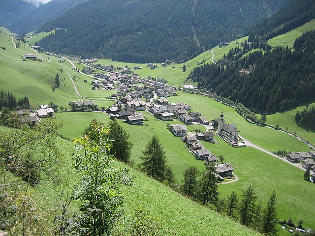
Сан-Кандидо (Innichen, San Candido)
.svg)
- коммуна в Италии
 Hiking in Сан-Кандидо
Innichen, known as San Candido in Italian, is a picturesque village located in the South Tyrol region of northern Italy. It’s surrounded by the stunning Dolomites, offering a plethora of hiking opportunities for all skill levels. Here are some key points to consider if you're planning a hiking trip to Innichen:
Hiking Trails:
-
The Three Peaks of Lavaredo: Located a short drive from Innichen, this iconic hike offers breathtaking views of the famous Dolomite peaks. The trail is moderate to challenging and typically takes about 3-4 hours.
-
Nature Park Fanes-Sennes-Braies: This nature park has a range of trails, from easy walks to more strenuous hikes. You can experience beautiful alpine scenery, diverse flora, and possibly even some wildlife.
-
The Winnebachsee: A more accessible hike, this trail takes you to a beautiful mountain lake just above Innichen. The round trip is about 4-5 hours and provides lovely views without being overly strenuous.
-
The Alta Via No. 1: For the more adventurous, this long-distance trail can be accessed from various points near Innichen. It stretches through the Dolomites and offers a mix of stunning landscapes, cultural experiences, and the chance to stay in mountain huts.
Best Time to Hike:
The best time for hiking in Innichen is generally from late spring to early autumn, roughly May to September, when the trails are usually free of snow and the weather is more stable. However, late autumn is also a beautiful time to visit for those who enjoy the changing colors of nature.
Essentials to Bring:
- Good Hiking Boots: The terrain can be uneven, so sturdy footwear is essential.
- Weather-Appropriate Clothing: The weather can change rapidly in the mountains, so layers are key.
- Map and Compass or GPS Device: While many trails are well-marked, having a map is always a good backup.
- Water and Snacks: Hydration and energy are crucial for longer hikes.
- First Aid Kit: Always a good idea to have for minor injuries.
Local Wildlife and Nature:
While hiking, keep an eye out for local wildlife such as chamois, marmots, and various bird species. The flora is diverse, with beautiful wildflowers in the summer months.
Additional Tips:
- Respect Nature: Follow the Leave No Trace principles to protect the environment.
- Stay Informed: Check local weather forecasts and trail conditions before heading out.
- Be Prepared: If you're unsure of your hiking skills, consider hiring a local guide for more challenging trails.
Hiking in Innichen offers not just the thrill of outdoor adventure but also an opportunity to immerse yourself in the stunning beauty of the Dolomites, making it a fantastic destination for hikers.
- Страна:

- Почтовый код: 39038
- Телефонный код: 0474
- Код автомобильного номера: BZ
- Координаты: 46° 43' 57" N, 12° 16' 43" E


- GPS треки (wikiloc): [Ссылка]
- Высота над уровнем моря: 1175 м m
- Площадь: 79.85 кв.км
- Население: 3317
- Веб сайт: http://www.gemeinde.innichen.bz.it/
- Википедия русская: wiki(ru)
- Википедия английская: wiki(en)
- Википедия национальная: wiki(it)
- Хранилище Wikidata: Wikidata: Q474782
- Галерея изображений в википедии: [Ссылка]
- Катеория в википедии: [Ссылка]
- код Freebase: [/m/0g9j88]
- код GeoNames: Альт: [6535923]
- код VIAF: Альт: [168700127]
- ID отношения в OpenStreetMap: [47309]
- код GND: Альт: [4072832-8]
- идентификатор местоположения ArchINFORM: [10122]
- код LCNAF: Альт: [n91008868]
- место в MusicBrainz: [772b558a-0e60-4c5e-8259-523049817afb]
- UN/LOCODE: [ITSCD]
- код в Большой российской энциклопедии онлайн: [3532082]
- код Цифрового атласа Римской империи: [732]
- код ISTAT: 021077
- кадастровый код Италии: H786
Граничит с регионами:

Иннерфильгратен
Hiking in Иннерфильгратен
Innervillgraten, located in the picturesque East Tyrol region of Austria, is a hidden gem for hiking enthusiasts. Surrounded by stunning mountain scenery, this charming village offers a wealth of hiking trails suitable for various skill levels, making it a perfect destination for both families and serious trekkers....
- Страна:

- Почтовый код: 9932
- Телефонный код: 04843
- Код автомобильного номера: LZ
- Координаты: 46° 48' 24" N, 12° 22' 23" E
- GPS треки (wikiloc): [Ссылка]
- Высота над уровнем моря: 1402 м m
- Площадь: 87.8 кв.км
- Население: 938
- Веб сайт: [Ссылка]

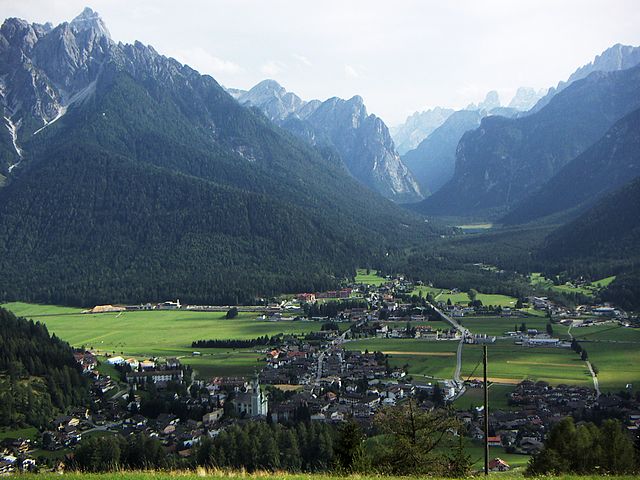
Сесто
- коммуна в Италии
Hiking in Сесто
Sexten, also known as Sesto, is a stunning destination located in the Dolomites of northern Italy. It offers a fantastic range of hiking opportunities for all levels of experience, all surrounded by breathtaking mountain scenery. Here are some key points to consider when hiking in Sexten:...
- Страна:
- Почтовый код: 39030
- Телефонный код: 0474
- Код автомобильного номера: BZ
- Координаты: 46° 42' 0" N, 12° 21' 0" E
- GPS треки (wikiloc): [Ссылка]
- Высота над уровнем моря: 1310 м m
- Площадь: 80.42 кв.км
- Население: 1906
- Веб сайт: [Ссылка]

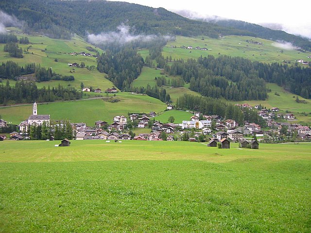
Доббьяко
- коммуна Италии
Hiking in Доббьяко
Toblach, located in the South Tyrol region of northern Italy, is a beautiful destination for hikers, thanks to its stunning landscapes and well-marked trails. Here’s an overview of what you can expect when hiking in Toblach:...
- Страна:
- Почтовый код: 39034
- Телефонный код: 0474
- Код автомобильного номера: BZ
- Координаты: 46° 44' 7" N, 12° 13' 20" E
- GPS треки (wikiloc): [Ссылка]
- Высота над уровнем моря: 1241 м m
- Площадь: 125.42 кв.км
- Население: 3346
- Веб сайт: [Ссылка]


Зиллиан
Hiking in Зиллиан
Sillian, located in the eastern part of Tyrol, Austria, is a fantastic destination for hiking enthusiasts. Nestled amidst stunning alpine landscapes, Sillian offers a wide range of trails that cater to all skill levels, from gentle walks to challenging mountain hikes....
- Страна:
- Почтовый код: 9920
- Телефонный код: 04842
- Код автомобильного номера: LZ
- Координаты: 46° 45' 10" N, 12° 25' 16" E
- GPS треки (wikiloc): [Ссылка]
- Высота над уровнем моря: 1103 м m
- Площадь: 36.26 кв.км
- Население: 2051
- Веб сайт: [Ссылка]