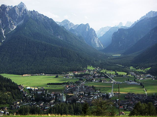
Сесто (Sexten, Sesto)
.svg)
- коммуна в Италии
 Hiking in Сесто
Sexten, also known as Sesto, is a stunning destination located in the Dolomites of northern Italy. It offers a fantastic range of hiking opportunities for all levels of experience, all surrounded by breathtaking mountain scenery. Here are some key points to consider when hiking in Sexten:
Terrain and Trails
-
Variety of Trails: The area boasts a network of well-marked trails, ranging from easy strolls to challenging alpine routes. Popular hikes include the Alta Via 3, which is part of the greater Alta Via network in the Dolomites.
-
Elevation: Hikes can vary significantly in elevation gain, so it's essential to choose a trail that matches your fitness level. Some trails offer stunning vistas with relatively easy ascents.
-
Lakes and Waterfalls: Hikers can enjoy picturesque lakes, such as the Toblino Lake and various waterfalls that can be found along certain trails.
Popular Hikes
- Val di Sesto: A scenic valley with several hiking options, ranging from easy walks to more demanding trails that lead to high mountain passes.
- Rotwand-Hütte: A moderate hike that takes you to beautiful viewpoints of the surrounding peaks.
- Dreischusterspitze: For experienced hikers, this mountain offers routes that can be more challenging but equally rewarding with incredible panoramic views.
Seasonal Considerations
- Summer: The best time for hiking is typically from late spring to early autumn (May to September). However, weather can change rapidly.
- Winter: While most trails may be snow-covered and challenging, Sexten also offers winter hiking trails and ski tourism, making it a year-round destination.
Equipment and Safety
- Proper Gear: Ensure you have sturdy hiking boots, weather-appropriate attire, and sufficient water and snacks for your hike.
- Navigation: Carry a map or GPS device, as some trails can be less well-marked or confusing in spots.
- Local Knowledge: Consider stopping by a local information center to get updated trail conditions and recommendations.
Accommodations and Facilities
- Mountain Huts: There are numerous rifugios (mountain huts) along the trails, where you can take breaks, enjoy local cuisine, and sometimes even stay overnight.
- Transportation: Sexten is accessible by public transport, and many trails have starting points that are easy to reach.
Tips for Hikers
- Start Early: Especially in summer, to avoid crowds and make the most of your day.
- Mind the Weather: Always check the forecast before heading out and be prepared for sudden changes.
- Leave No Trace: Respect the natural environment by following Leave No Trace principles.
Overall, hiking in Sexten is a memorable experience filled with natural beauty, diverse trails, and the charm of the Dolomites. Enjoy your adventures in this breathtaking region!
- Страна:

- Почтовый код: 39030
- Телефонный код: 0474
- Код автомобильного номера: BZ
- Координаты: 46° 42' 0" N, 12° 21' 0" E


- GPS треки (wikiloc): [Ссылка]
- Высота над уровнем моря: 1310 м m
- Площадь: 80.42 кв.км
- Население: 1906
- Веб сайт: http://www.gemeinde.sexten.bz.it
- Википедия русская: wiki(ru)
- Википедия английская: wiki(en)
- Википедия национальная: wiki(it)
- Хранилище Wikidata: Wikidata: Q256337
- Галерея изображений в википедии: [Ссылка]
- Катеория в википедии: [Ссылка]
- код Freebase: [/m/0420qc]
- код GeoNames: Альт: [6535929]
- код VIAF: Альт: [168684429]
- ID отношения в OpenStreetMap: [47286]
- код GND: Альт: [4077388-7]
- идентификатор местоположения ArchINFORM: [10123]
- код LCNAF: Альт: [n84120404]
- код темы Quora: [Sexten]
- UN/LOCODE: [ITSBZ]
- код NKC: [ge964646]
- код ISTAT: 021092
- кадастровый код Италии: I687
Граничит с регионами:

Доббьяко
- коммуна Италии
Hiking in Доббьяко
Toblach, located in the South Tyrol region of northern Italy, is a beautiful destination for hikers, thanks to its stunning landscapes and well-marked trails. Here’s an overview of what you can expect when hiking in Toblach:...
- Страна:
- Почтовый код: 39034
- Телефонный код: 0474
- Код автомобильного номера: BZ
- Координаты: 46° 44' 7" N, 12° 13' 20" E
- GPS треки (wikiloc): [Ссылка]
- Высота над уровнем моря: 1241 м m
- Площадь: 125.42 кв.км
- Население: 3346
- Веб сайт: [Ссылка]


Комелико-Супериоре
- коммуна Италии
Hiking in Комелико-Супериоре
Comelico Superiore is a beautiful destination located in the Dolomites, specifically in the province of Belluno, Italy. It's part of the Cadore region and is known for its stunning natural landscapes, rich culture, and excellent hiking opportunities. Here are some highlights about hiking in Comelico Superiore:...
- Страна:
- Почтовый код: 32040
- Телефонный код: 0435
- Код автомобильного номера: BL
- Координаты: 46° 35' 21" N, 12° 30' 53" E
- GPS треки (wikiloc): [Ссылка]
- Высота над уровнем моря: 1210 м m
- Площадь: 96.15 кв.км
- Население: 2157
- Веб сайт: [Ссылка]


Ауронцо-ди-Кадоре
- коммуна Италии
Hiking in Ауронцо-ди-Кадоре
Auronzo di Cadore is a stunning destination located in the Dolomites of northeastern Italy, known for its breathtaking landscapes, rich history, and a plethora of outdoor activities, particularly hiking. Here’s an overview of what to expect when hiking in Auronzo di Cadore:...
- Страна:
- Почтовый код: 32041
- Телефонный код: 0435
- Код автомобильного номера: BL
- Координаты: 46° 33' 0" N, 12° 26' 0" E
- GPS треки (wikiloc): [Ссылка]
- Высота над уровнем моря: 862 м m
- Площадь: 220.65 кв.км
- Население: 3302
- Веб сайт: [Ссылка]


Сан-Кандидо
- коммуна в Италии
Hiking in Сан-Кандидо
Innichen, known as San Candido in Italian, is a picturesque village located in the South Tyrol region of northern Italy. It’s surrounded by the stunning Dolomites, offering a plethora of hiking opportunities for all skill levels. Here are some key points to consider if you're planning a hiking trip to Innichen:...
- Страна:
- Почтовый код: 39038
- Телефонный код: 0474
- Код автомобильного номера: BZ
- Координаты: 46° 43' 57" N, 12° 16' 43" E
- GPS треки (wikiloc): [Ссылка]
- Высота над уровнем моря: 1175 м m
- Площадь: 79.85 кв.км
- Население: 3317
- Веб сайт: [Ссылка]


Зиллиан
Hiking in Зиллиан
Sillian, located in the eastern part of Tyrol, Austria, is a fantastic destination for hiking enthusiasts. Nestled amidst stunning alpine landscapes, Sillian offers a wide range of trails that cater to all skill levels, from gentle walks to challenging mountain hikes....
- Страна:

- Почтовый код: 9920
- Телефонный код: 04842
- Код автомобильного номера: LZ
- Координаты: 46° 45' 10" N, 12° 25' 16" E
- GPS треки (wikiloc): [Ссылка]
- Высота над уровнем моря: 1103 м m
- Площадь: 36.26 кв.км
- Население: 2051
- Веб сайт: [Ссылка]


Картич
Hiking in Картич
Kartitsch is a charming village located in the Austrian Alps, known for its stunning natural landscapes and excellent hiking opportunities. Nestled in the East Tyrol region, it offers a variety of trails that cater to different experience levels. Here are some key highlights for hiking in Kartitsch:...
- Страна:
- Почтовый код: 9941
- Телефонный код: 04848
- Код автомобильного номера: LZ
- Координаты: 46° 43' 0" N, 12° 29' 0" E
- GPS треки (wikiloc): [Ссылка]
- Высота над уровнем моря: 1353 м m
- Площадь: 58.91 кв.км
- Население: 803
- Веб сайт: [Ссылка]