Иссим (Issime, Issime)
.svg)
- коммуна Италии
 Hiking in Иссим
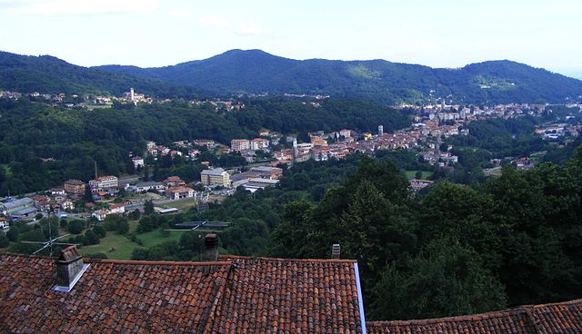
Issime is a charming municipality located in the Aosta Valley region of Italy, nestled in the Alps. It offers a variety of hiking opportunities that cater to different levels of experience, making it a great destination for outdoor enthusiasts.
Hiking Trails
-
Bivacco Tazzetti: This hike offers a moderately challenging trail that rewards you with breathtaking views of the surrounding mountains. The route usually takes about 3 to 4 hours to reach the bivouac, where you can take a break and enjoy the landscape.
-
Lago di Goletta: This is a beautiful hike that leads you to the serene Lago di Goletta. The trail is well-marked and relatively easy, making it suitable for families or less experienced hikers. The lake itself is a great spot for picnicking.
-
Sentiero dei Vinaio: For those looking for a longer and more challenging hike, this trail takes you through stunning alpine meadows and offers panoramic views of the valley. It's recommended to allow a full day for this hike.
Best Time to Hike
The best time to hike in Issime is between late spring and early fall (June to September) when the weather is mild and the trails are accessible. Always check local conditions, especially in early spring or late fall when snow might still cover higher elevations.
Preparation
- Gear: Proper hiking shoes, layered clothing, and a good backpack are essential. Don’t forget essentials like water, snacks, and, depending on the season, sun protection or a lightweight rain jacket.
- Navigation: Although trails are generally well-marked, carrying a map or GPS device can be helpful, especially for more remote routes.
- Wildlife and Nature: Be respectful of the natural environment. Take your trash with you, and be mindful of local wildlife.
Local Amenities
Issime has several local accommodations, cafes, and shops where you can stock up on supplies or enjoy a meal after a day of hiking. The local culture, including traditional Aostan cuisine, is also a great way to unwind after a day on the trails.
Safety Tips
- Always let someone know your hiking plans.
- Check the weather forecast before heading out.
- Be aware of your physical limits and choose trails that match your fitness level.
Whether you're looking for a leisurely stroll or an adventurous trek, hiking in Issime can offer a perfect blend of beautiful landscapes and cultural experiences. Enjoy your hike!
- Страна:

- Почтовый код: 11020
- Телефонный код: 0125
- Код автомобильного номера: AO
- Координаты: 45° 41' 0" N, 7° 51' 0" E


- GPS треки (wikiloc): [Ссылка]
- Высота над уровнем моря: 956 м m
- Площадь: 35.38 кв.км
- Население: 413
- Веб сайт: http://www.comune.issime.ao.it
- Википедия русская: wiki(ru)
- Википедия английская: wiki(en)
- Википедия национальная: wiki(it)
- Хранилище Wikidata: Wikidata: Q35097
- Галерея изображений в википедии: [Ссылка]
- Катеория в википедии: [Ссылка]
- Карты в википедии: [Ссылка]
- код GeoNames: Альт: [6536461]
- код VIAF: Альт: [147933892]
- ID отношения в OpenStreetMap: [45671]
- код ISTAT: 007036
- кадастровый код Италии: E369
Граничит с регионами:
Сальяно-Микка
- коммуна Италии
Hiking in Сальяно-Микка
Sagliano Micca is a charming municipality located in the Biella region of Piedmont, Italy. It is nestled in the beautiful foothills of the Alps, making it an excellent destination for hiking enthusiasts. Here are some highlights and tips regarding hiking in and around Sagliano Micca:...
- Страна:
- Почтовый код: 13816
- Телефонный код: 015
- Код автомобильного номера: BI
- Координаты: 45° 37' 0" N, 8° 3' 0" E
- GPS треки (wikiloc): [Ссылка]
- Высота над уровнем моря: 589 м m
- Площадь: 14.61 кв.км
- Население: 1610
- Веб сайт: [Ссылка]


Арна
- коммуна Италии
Hiking in Арна
Arnad is a charming commune located in the Aosta Valley region of Italy, known for its beautiful landscapes and outdoor activities, particularly hiking. Nestled in the foothills of the Alps, Arnad offers a variety of trails suitable for different skill levels, making it an excellent destination for both novice and experienced hikers....
- Страна:
- Почтовый код: 11020
- Телефонный код: 0125
- Код автомобильного номера: AO
- Координаты: 45° 38' 0" N, 7° 43' 0" E
- GPS треки (wikiloc): [Ссылка]
- Высота над уровнем моря: 361 м m
- Площадь: 28.84 кв.км
- Население: 1251
- Веб сайт: [Ссылка]


Брюссон
- коммуна Италии
Hiking in Брюссон
Brusson is a charming village located in the Aosta Valley region of Italy, known for its stunning natural scenery and excellent hiking opportunities. Nestled in the midst of the Alps, Brusson offers a mix of challenging trails and easier walks suitable for hikers of all levels. Here’s what you need to know about hiking in Brusson:...
- Страна:
- Почтовый код: 11022
- Телефонный код: 0125
- Код автомобильного номера: AO
- Координаты: 45° 46' 0" N, 7° 44' 0" E
- GPS треки (wikiloc): [Ссылка]
- Высота над уровнем моря: 1338 м m
- Площадь: 55.26 кв.км
- Население: 887
- Веб сайт: [Ссылка]


Шаллан-Сент-Ансельм
- коммуна Италии
Hiking in Шаллан-Сент-Ансельм
Challand-Saint-Anselme is a charming village located in the Aosta Valley of Italy, surrounded by beautiful mountainous landscapes, making it an excellent destination for hiking enthusiasts. Here are some highlights and tips for hiking in the area:...
- Страна:
- Почтовый код: 11020
- Телефонный код: 0125
- Код автомобильного номера: AO
- Координаты: 45° 43' 0" N, 7° 44' 0" E
- GPS треки (wikiloc): [Ссылка]
- Высота над уровнем моря: 1030 м m
- Площадь: 27.99 кв.км
- Население: 743
- Веб сайт: [Ссылка]


Шаллан-Сен-Виктор
- коммуна Италии
Hiking in Шаллан-Сен-Виктор
Challand-Saint-Victor is a charming village located in the Aosta Valley region of Italy, known for its picturesque mountain scenery and rich natural landscapes. The area offers a variety of hiking opportunities that cater to different skill levels, making it a great destination for both novice and experienced hikers....
- Страна:
- Почтовый код: 11020
- Телефонный код: 0125
- Код автомобильного номера: AO
- Координаты: 45° 41' 0" N, 7° 42' 0" E
- GPS треки (wikiloc): [Ссылка]
- Высота над уровнем моря: 744 м m
- Площадь: 25 кв.км
- Население: 557
- Веб сайт: [Ссылка]


Фонтенмор
- коммуна Италии
Hiking in Фонтенмор
Fontainemore is a charming village located in the Aosta Valley region of northwestern Italy, known for its stunning natural landscapes and excellent hiking opportunities. Nestled among the mountains, Fontainemore offers a variety of trails suitable for different skill levels, making it a great destination for both beginners and experienced hikers....
- Страна:
- Почтовый код: 11020
- Телефонный код: 0125
- Код автомобильного номера: AO
- Координаты: 45° 39' 0" N, 7° 52' 0" E
- GPS треки (wikiloc): [Ссылка]
- Высота над уровнем моря: 760 м m
- Площадь: 31.71 кв.км
- Население: 434
- Веб сайт: [Ссылка]


Габи
- коммуна Италии
Hiking in Габи
Gaby is a charming small village located in the Aosta Valley region of Italy, which is known for its stunning mountainous landscapes, rich history, and outdoor activities, including hiking. Here are some key points to consider when planning a hiking trip in and around Gaby:...
- Страна:
- Почтовый код: 11020
- Телефонный код: 0125
- Код автомобильного номера: AO
- Координаты: 45° 42' 16" N, 7° 53' 2" E
- GPS треки (wikiloc): [Ссылка]
- Высота над уровнем моря: 1047 м m
- Площадь: 32.17 кв.км
- Население: 467
- Веб сайт: [Ссылка]


Лилльян
- коммуна Италии
Hiking in Лилльян
Lillianes is a small village located in the Aosta Valley region of northern Italy, nestled in a picturesque setting at the foot of the Alps. It’s an excellent starting point for various hiking adventures, offering stunning views, rich flora and fauna, and a chance to experience the natural beauty of the region....
- Страна:
- Почтовый код: 11020
- Телефонный код: 0125
- Код автомобильного номера: AO
- Координаты: 45° 38' 0" N, 7° 51' 0" E
- GPS треки (wikiloc): [Ссылка]
- Высота над уровнем моря: 667 м m
- Площадь: 18.55 кв.км
- Население: 456
- Веб сайт: [Ссылка]


Перло
- коммуна в автономном регионе Валле-д’Аоста, Италия
Hiking in Перло
Perloz is a picturesque village located in the Aosta Valley region of Italy, surrounded by stunning alpine scenery, which makes it an excellent destination for hiking enthusiasts. Here are some key points to consider when hiking in Perloz:...
- Страна:
- Почтовый код: 11002
- Телефонный код: 0125
- Код автомобильного номера: AO
- Координаты: 45° 37' 0" N, 7° 49' 0" E
- GPS треки (wikiloc): [Ссылка]
- Высота над уровнем моря: 661 м m
- Площадь: 23.27 кв.км
- Население: 480
- Веб сайт: [Ссылка]