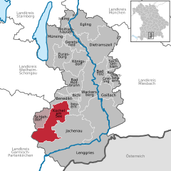
Яхенау (Jachenau, Jachenau)

- коммуна в Германии
 Hiking in Яхенау
Jachenau is a beautiful hiking destination located in the foothills of the Bavarian Alps, specifically in the state of Bavaria, Germany. This area is renowned for its stunning natural landscapes, picturesque valleys, and alpine scenery. Here are some highlights and tips for hiking in Jachenau:
Hiking Trails
-
Jachenau Valley Trail: This scenic trail offers a delightful way to experience the natural beauty of the valley. The path winds through lush forests, alongside meadows, and often provides views of the surrounding mountains.
-
Miesenbach Waterfall: A popular hike that leads to the impressive Miesenbach Waterfall, this trail covers about 2-3 km and is suitable for families. The waterfall is a great spot for photography.
-
Guffert Mountain: For those looking for a more challenging hike, summiting Guffert Mountain is a rewarding option. The trail is steep and may take around 3-4 hours to reach the summit, but the panoramic views from the top are worth the effort.
-
Zugspitze and Surrounding Trails: While not directly in Jachenau, the Zugspitze massif is nearby and offers numerous challenging hikes, with breathtaking views of the Alps. It's a popular destination for more experienced hikers.
Key Considerations
-
Trail Marking: Most trails in Jachenau are well-marked, but it's always a good practice to bring a map or use a hiking app for navigation.
-
Weather: The weather can change rapidly in the mountains, so be sure to check forecasts and dress in layers. Carrying rain gear and extra clothing is advisable.
-
Wildlife: Be respectful of nature and wildlife. Always stay on designated trails to protect the environment.
-
Local Tips: Stop by local inns or gasthaus for traditional Bavarian food, which can be a nice treat after a long hike.
Preparation
- Footwear: Wear sturdy hiking boots to ensure comfort and support on uneven terrain.
- Hydration: Carry enough water, especially during warmer months. There are few spots to refill, so plan accordingly.
- Safety: Let someone know your plans if you are hiking alone and carry a small first aid kit.
Conclusion
Hiking in Jachenau offers a mix of leisurely and challenging trails set against the backdrop of Bavaria’s natural beauty. Whether you're an avid hiker seeking high altitudes or a family looking for a leisurely walk, Jachenau has something to offer for everyone. Enjoy the fresh air and breathtaking scenery!
- Страна:

- Почтовый код: 83676
- Телефонный код: 08043
- Координаты: 47° 36' 0" N, 11° 26' 0" E


- GPS треки (wikiloc): [Ссылка]
- Высота над уровнем моря: 790 м m
- Площадь: 128.63 кв.км
- Население: 848
- Веб сайт: http://www.jachenau.de
- Википедия русская: wiki(ru)
- Википедия английская: wiki(en)
- Википедия национальная: wiki(de)
- Хранилище Wikidata: Wikidata: Q535418
- Катеория в википедии: [Ссылка]
- код Freebase: [/m/02q0yjv]
- код GeoNames: Альт: [2895517]
- код VIAF: Альт: [244117503]
- ID отношения в OpenStreetMap: [935251]
- код GND: Альт: [4109183-8]
- код Historical Gazetteer: [object_300289]
- Bavarikon ID: [ODB_A00000960]
- идентификатор муниципалитетов в Германии: 09173131
Граничит с регионами:

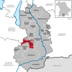
Кохель-ам-Зее
Hiking in Кохель-ам-Зее
Kochel, located in Bavaria, Germany, is a fantastic spot for hiking enthusiasts. Nestled between the beautiful landscape of the Bavarian Alps and the lovely Kochelsee lake, it offers a diverse range of hiking trails suitable for all skill levels. Here are some highlights of hiking in Kochel:...
- Страна:
- Почтовый код: 82432; 82431
- Телефонный код: 08858; 08851
- Координаты: 47° 39' 31" N, 11° 22' 6" E
- GPS треки (wikiloc): [Ссылка]
- Высота над уровнем моря: 605 м m
- Площадь: 80.11 кв.км
- Население: 4106
- Веб сайт: [Ссылка]

Бенедиктбойерн
Hiking in Бенедиктбойерн
Benediktbeuern is a picturesque village located in Bavaria, Germany, nestled in the foothills of the Alps. It offers a range of hiking opportunities suitable for various skill levels, making it a great destination for both casual walkers and more experienced hikers....
- Страна:
- Почтовый код: 83671
- Телефонный код: 08857
- Координаты: 47° 42' 24" N, 11° 24' 42" E
- GPS треки (wikiloc): [Ссылка]
- Высота над уровнем моря: 640 м m
- Площадь: 37.86 кв.км
- Население: 3620
- Веб сайт: [Ссылка]