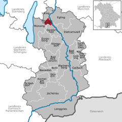
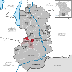
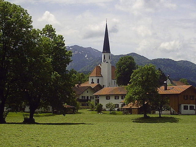
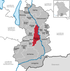
Бад-Тёльц-Вольфратсхаузен (Bad Tölz-Wolfratshausen, Landkreis Bad Tölz-Wolfratshausen)

- район Баварии
 Hiking in Бад-Тёльц-Вольфратсхаузен
Bad Tölz-Wolfratshausen is a picturesque region in Bavaria, Germany, known for its stunning landscapes and excellent hiking opportunities. Nestled in the foothills of the Alps, this area offers a variety of trails that cater to different skill levels, from gentle walks suitable for families to more challenging hikes for experienced adventurers.
Highlights of Hiking in Bad Tölz-Wolfratshausen:
-
Scenic Trails: The region boasts a network of well-marked hiking trails that provide breathtaking views of the surrounding mountains, rivers, and lush forests. Popular trails include those along the Isar River and ascents into the nearby mountains.
-
Nature Parks: The nearby nature reserves, such as the Isarwinkel and the mountains of the Bavarian Alps, are perfect for nature lovers. You can experience diverse flora and fauna, cascading waterfalls, and serene lakes.
-
Charming Villages: On your hikes, you'll often pass through quaint Bavarian villages like Bad Tölz, known for its historic town center, and Wolfratshausen, where you can enjoy local cuisine and traditional Bavarian culture.
-
Rundwanderung (Circular Hikes): Many trails offer circular routes, which are great for providing diverse experiences without the need to retrace your steps. Look for trails that intersect or connect with one another to create your own adventure.
-
Seasonal Hiking: Each season offers a unique perspective of the landscape. Spring and summer are perfect for wildflowers and greenery, autumn showcases beautiful foliage, and winter can provide opportunities for snowshoeing or winter hiking.
-
Hints for Hikers:
- Preparation: Always check trail conditions and weather forecasts before you head out. Trails can vary in difficulty and some may be affected by weather conditions.
- Gear: Wear appropriate footwear, and carry enough water and snacks. A small first-aid kit is also advisable.
- Local Regulations: Respect nature and follow local guidelines, especially regarding wildlife and plant protection.
-
Guided Tours: If you're new to hiking or unfamiliar with the region, consider joining a guided tour. Local guides can provide valuable insights into the area's geology, history, and wildlife.
By exploring the trails of Bad Tölz-Wolfratshausen, hikers can enjoy not only physical activity but also a deep connection with nature and the charming Bavarian culture. Whether you're hiking with friends, family, or solo, you're sure to have a memorable experience in this beautiful region.
- Страна:

- Столица: Бад-Тёльц
- Код автомобильного номера: WOR; TÖL
- Координаты: 47° 45' 0" N, 11° 34' 48" E


- GPS треки (wikiloc): [Ссылка]
- Высота над уровнем моря: 848 м m
- Площадь: 1111.00 кв.км
- Население: 126572
- Веб сайт: http://www.lra-toelz.de/
- Википедия русская: wiki(ru)
- Википедия английская: wiki(en)
- Википедия национальная: wiki(de)
- Хранилище Wikidata: Wikidata: Q10522
- Катеория в википедии: [Ссылка]
- Карты в википедии: [Ссылка]
- код Freebase: [/m/01ck9g]
- код GeoNames: Альт: [2953323]
- код VIAF: Альт: [151924011]
- ID отношения в OpenStreetMap: [62472]
- код GND: Альт: [4060319-2]
- идентификатор местоположения ArchINFORM: [2328]
- код LCNAF: Альт: [n83012865]
- код TGN: [7208552]
- код Historical Gazetteer: [adm_139173]
- Bavarikon ID: [ODB_A00000948]
- код ISNI: Альт: [0000 0004 0480 4778]
- код NUTS: [DE216]
- код BabelNet: [01284603n]
- код района Германии: 09173
Включает регионы:


Pupplinger Au
Hiking in Pupplinger Au
Pupplinger Au is a beautiful natural area located in Bavaria, Germany, along the banks of the Isar River, just south of Munich. The region is known for its scenic landscapes, rich biodiversity, and outdoor recreational opportunities, making it a great destination for hiking enthusiasts....
- Страна:
- Координаты: 47° 55' 55" N, 11° 26' 19" E
- GPS треки (wikiloc): [Ссылка]
- Площадь: 3.72 кв.км
- Население: 0
Иккинг
Hiking in Иккинг
Icking is a small village located in Bavaria, Germany, in the district of Munich. While it may not be as widely known as some other hiking destinations in Germany, it offers a charming experience for outdoor enthusiasts, especially those who appreciate scenic landscapes and a peaceful atmosphere....
- Страна:
- Почтовый код: 82057
- Телефонный код: 08171; 08178
- Координаты: 47° 57' 0" N, 11° 26' 0" E
- GPS треки (wikiloc): [Ссылка]
- Высота над уровнем моря: 636 м m
- Площадь: 16.99 кв.км
- Население: 3186
- Веб сайт: [Ссылка]

Бад-Хайльбрунн
Hiking in Бад-Хайльбрунн
Bad Heilbrunn, located in Bavaria, Germany, is a picturesque destination for hiking enthusiasts. Nestled in the foothills of the Bavarian Alps, it offers a variety of hiking trails that cater to different skill levels, from leisurely strolls to more challenging treks....
- Страна:
- Почтовый код: 83670
- Телефонный код: 08046
- Координаты: 47° 45' 0" N, 11° 27' 0" E
- GPS треки (wikiloc): [Ссылка]
- Высота над уровнем моря: 682 м m
- Площадь: 40.32 кв.км
- Население: 3822
- Веб сайт: [Ссылка]

Кохель-ам-Зее
Hiking in Кохель-ам-Зее
Kochel, located in Bavaria, Germany, is a fantastic spot for hiking enthusiasts. Nestled between the beautiful landscape of the Bavarian Alps and the lovely Kochelsee lake, it offers a diverse range of hiking trails suitable for all skill levels. Here are some highlights of hiking in Kochel:...
- Страна:
- Почтовый код: 82432; 82431
- Телефонный код: 08858; 08851
- Координаты: 47° 39' 31" N, 11° 22' 6" E
- GPS треки (wikiloc): [Ссылка]
- Высота над уровнем моря: 605 м m
- Площадь: 80.11 кв.км
- Население: 4106
- Веб сайт: [Ссылка]


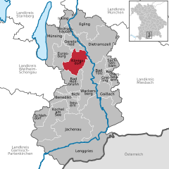
Эглинг
Hiking in Эглинг
Egling is a small town located in Bavaria, Germany, not far from the scenic landscape of the Bavarian Alps. It serves as a great starting point for various hiking trails that cater to different skill levels and interests. Here are some aspects to consider when hiking in and around Egling:...
- Страна:
- Почтовый код: 82544
- Телефонный код: 08176
- Координаты: 47° 55' 0" N, 11° 31' 0" E
- GPS треки (wikiloc): [Ссылка]
- Высота над уровнем моря: 609 м m
- Площадь: 74.06 кв.км
- Население: 4031
- Веб сайт: [Ссылка]


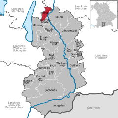
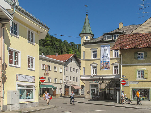
Бад-Тёльц
Hiking in Бад-Тёльц
Bad Tölz, located in Bavaria, Germany, is a beautiful destination known for its scenic landscapes and charming old town. It makes for an excellent base for hiking enthusiasts, offering a variety of trails that cater to different skill levels....
- Страна:
- Почтовый код: 83646
- Телефонный код: 08041
- Код автомобильного номера: TÖL
- Координаты: 47° 45' 37" N, 11° 33' 24" E
- GPS треки (wikiloc): [Ссылка]
- Высота над уровнем моря: 658 м m
- Площадь: 30.80 кв.км
- Население: 18475
- Веб сайт: [Ссылка]

Кёнигсдорф
Hiking in Кёнигсдорф
Königsdorf is a picturesque village located in Bavaria, Germany, surrounded by beautiful natural landscapes that offer excellent hiking opportunities. The area is characterized by rolling hills, dense forests, and stunning views of the surrounding mountains, making it a great destination for both novice and experienced hikers....
- Страна:
- Почтовый код: 82549
- Телефонный код: 08046; 08171; 08179
- Координаты: 47° 49' 0" N, 11° 29' 0" E
- GPS треки (wikiloc): [Ссылка]
- Высота над уровнем моря: 625 м m
- Площадь: 45.69 кв.км
- Население: 2988
- Веб сайт: [Ссылка]
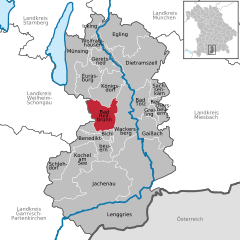
Вольфратсхаузен
Hiking in Вольфратсхаузен
Wolfratshausen, located in Bavaria, Germany, is a charming town that serves as an excellent base for hiking enthusiasts. Nestled near the scenic Isar River and surrounded by beautiful landscapes, it offers a variety of hiking trails suited for different skill levels....
- Страна:
- Почтовый код: 82515
- Телефонный код: 08171
- Код автомобильного номера: TÖL
- Координаты: 47° 54' 48" N, 11° 25' 40" E
- GPS треки (wikiloc): [Ссылка]
- Высота над уровнем моря: 576 м m
- Площадь: 9.13 кв.км
- Население: 17992
- Веб сайт: [Ссылка]

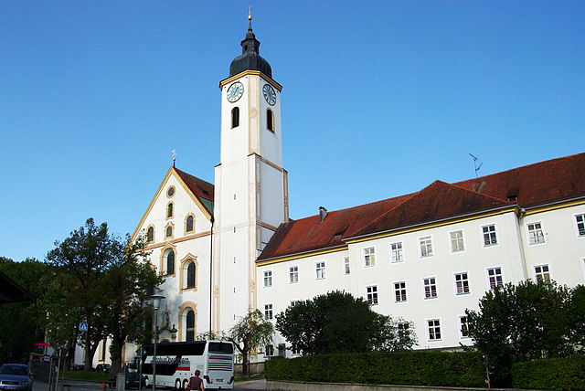
Бенедиктбойерн
Hiking in Бенедиктбойерн
Benediktbeuern is a picturesque village located in Bavaria, Germany, nestled in the foothills of the Alps. It offers a range of hiking opportunities suitable for various skill levels, making it a great destination for both casual walkers and more experienced hikers....
- Страна:
- Почтовый код: 83671
- Телефонный код: 08857
- Координаты: 47° 42' 24" N, 11° 24' 42" E
- GPS треки (wikiloc): [Ссылка]
- Высота над уровнем моря: 640 м m
- Площадь: 37.86 кв.км
- Население: 3620
- Веб сайт: [Ссылка]


Геретсрид
Hiking in Геретсрид
Geretsried, located in Bavaria, Germany, is a great spot for hiking enthusiasts due to its scenic natural surroundings and access to various trails. Nestled close to the foothills of the Alps, Geretsried offers a mix of easy walks and more challenging hikes, catering to different skill levels....
- Страна:
- Почтовый код: 82538
- Телефонный код: 08171
- Координаты: 47° 52' 0" N, 11° 28' 0" E
- GPS треки (wikiloc): [Ссылка]
- Высота над уровнем моря: 605 м m
- Площадь: 24.65 кв.км
- Население: 20722
- Веб сайт: [Ссылка]

Дитрамсцелль
Hiking in Дитрамсцелль
Dietramszell, located in the picturesque surroundings of Bavaria, Germany, offers a range of hiking opportunities that cater to various skill levels. Here are some key aspects to consider when hiking in and around Dietramszell:...
- Страна:
- Почтовый код: 83623
- Телефонный код: 08171; 08176; 08027
- Координаты: 47° 51' 0" N, 11° 36' 0" E
- GPS треки (wikiloc): [Ссылка]
- Высота над уровнем моря: 685 м m
- Площадь: 96.78 кв.км
- Население: 5442
- Веб сайт: [Ссылка]

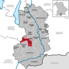
Бихль
Hiking in Бихль
Bichl is a small village located in Bavaria, Germany, near the beautiful landscape of the Alps. Hiking in this region offers a variety of trails that cater to different skill levels, from gentle walks to more challenging alpine routes. Here are some highlights regarding hiking in and around Bichl:...
- Страна:
- Почтовый код: 83673
- Телефонный код: 08857
- Координаты: 47° 43' 14" N, 11° 24' 43" E
- GPS треки (wikiloc): [Ссылка]
- Высота над уровнем моря: 625 м m
- Площадь: 13.92 кв.км
- Население: 1544
- Веб сайт: [Ссылка]
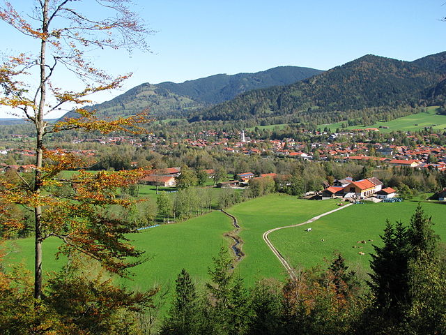
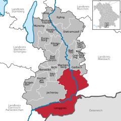
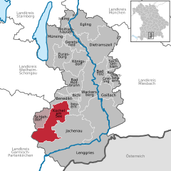
Ленгрис
Hiking in Ленгрис
Lenggries is a charming town located in Bavaria, Germany, and is surrounded by beautiful mountains, making it a great destination for hiking enthusiasts. The area offers a variety of trails suitable for all levels, from leisurely walks to challenging hikes, all amidst stunning natural scenery....
- Страна:
- Почтовый код: 83661
- Телефонный код: 08042
- Координаты: 47° 40' 49" N, 11° 34' 26" E
- GPS треки (wikiloc): [Ссылка]
- Высота над уровнем моря: 679 м m
- Площадь: 242.90 кв.км
- Население: 10001
- Веб сайт: [Ссылка]


Райхерсбойерн
Hiking in Райхерсбойерн
Reichersbeuern, a picturesque village in Bavaria, Germany, offers a variety of hiking opportunities in a stunning natural landscape, perfect for both beginners and seasoned hikers. Here are some highlights for hiking in and around Reichersbeuern:...
- Страна:
- Почтовый код: 83677
- Телефонный код: 08041
- Координаты: 47° 46' 0" N, 11° 38' 0" E
- GPS треки (wikiloc): [Ссылка]
- Высота над уровнем моря: 716 м m
- Площадь: 15.41 кв.км
- Население: 1581
- Веб сайт: [Ссылка]

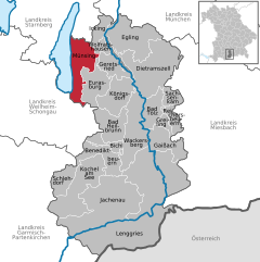
Мюнзинг
Hiking in Мюнзинг
Münsing, located in Bavaria, Germany, is a picturesque area near the Starnberger See, known for its beautiful landscapes and rich natural beauty. Hiking around Münsing offers a range of options for both beginners and experienced hikers. Here are some highlights:...
- Страна:
- Почтовый код: 82541
- Телефонный код: 08177
- Координаты: 47° 54' 0" N, 11° 22' 0" E
- GPS треки (wikiloc): [Ссылка]
- Высота над уровнем моря: 666 м m
- Площадь: 52.20 кв.км
- Население: 3317
- Веб сайт: [Ссылка]


Яхенау
- коммуна в Германии
Hiking in Яхенау
Jachenau is a beautiful hiking destination located in the foothills of the Bavarian Alps, specifically in the state of Bavaria, Germany. This area is renowned for its stunning natural landscapes, picturesque valleys, and alpine scenery. Here are some highlights and tips for hiking in Jachenau:...
- Страна:
- Почтовый код: 83676
- Телефонный код: 08043
- Координаты: 47° 36' 0" N, 11° 26' 0" E
- GPS треки (wikiloc): [Ссылка]
- Высота над уровнем моря: 790 м m
- Площадь: 128.63 кв.км
- Население: 848
- Веб сайт: [Ссылка]
Грайлинг
Hiking in Грайлинг
It seems there might be a bit of confusion about "Greiling." It’s possible you meant "Greiling" as a specific location, but it could also refer to a typo or misunderstanding of another popular hiking destination....
- Страна:
- Почтовый код: 83677
- Телефонный код: 08041
- Координаты: 47° 46' 0" N, 11° 37' 0" E
- GPS треки (wikiloc): [Ссылка]
- Высота над уровнем моря: 706 м m
- Площадь: 7.65 кв.км
- Население: 1038
- Веб сайт: [Ссылка]
Ваккерсберг
Hiking in Ваккерсберг
Wackersberg, located in Bavaria, Germany, is a charming area that offers a variety of hiking opportunities amidst stunning natural landscapes. Nestled near the town of Bad Tölz, it provides a serene environment with picturesque views of the surrounding Alps and the Isar River Valley....
- Страна:
- Почтовый код: 83646
- Телефонный код: 08041
- Координаты: 47° 44' 0" N, 11° 33' 0" E
- GPS треки (wikiloc): [Ссылка]
- Высота над уровнем моря: 735 м m
- Площадь: 64.83 кв.км
- Население: 2763
- Веб сайт: [Ссылка]


Гайссах
Hiking in Гайссах
Gaißach, located in Bavaria, Germany, is a picturesque area that offers a variety of hiking opportunities amidst stunning alpine scenery. The region is characterized by beautiful mountain vistas, lush meadows, and charming villages, making it a perfect destination for outdoor enthusiasts....
- Страна:
- Почтовый код: 83674
- Телефонный код: 08042; 08041
- Координаты: 47° 45' 0" N, 11° 35' 0" E
- GPS треки (wikiloc): [Ссылка]
- Высота над уровнем моря: 735 м m
- Площадь: 38.55 кв.км
- Население: 2570
- Веб сайт: [Ссылка]

Шледорф
Hiking in Шледорф
Schlehdorf, a picturesque village located in Bavaria, Germany, offers a range of beautiful hiking opportunities that allow you to explore its stunning natural landscapes. Nestled near the foothills of the Alps and close to the Kochelsee lake, the area is characterized by rolling hills, scenic views, and lush forests....
- Страна:
- Почтовый код: 82444
- Телефонный код: 08851
- Координаты: 47° 39' 18" N, 11° 18' 48" E
- GPS треки (wikiloc): [Ссылка]
- Высота над уровнем моря: 604 м m
- Площадь: 25.39 кв.км
- Население: 1223
- Веб сайт: [Ссылка]


Ойрасбург
Hiking in Ойрасбург
Eurasburg, located in Bavaria, Germany, is a charming destination for hiking enthusiasts. The region offers a mix of gentle hills and picturesque countryside, making it ideal for a variety of hiking experiences suitable for all skill levels. Here are some highlights of hiking in Eurasburg:...
- Страна:
- Почтовый код: 82547
- Телефонный код: 08179
- Координаты: 47° 52' 0" N, 11° 24' 0" E
- GPS треки (wikiloc): [Ссылка]
- Высота над уровнем моря: 600 м m
- Площадь: 40.9 кв.км
- Население: 2894
- Веб сайт: [Ссылка]


Заксенкам
Hiking in Заксенкам
Sachsenkam, located in Bavaria, Germany, is a picturesque area suitable for hiking enthusiasts. Nestled at the foot of the Alps, it offers a range of trails that cater to different skill levels, from easy walks to more challenging hikes....
- Страна:
- Почтовый код: 83679
- Телефонный код: 08021
- Координаты: 47° 48' 0" N, 11° 39' 0" E
- GPS треки (wikiloc): [Ссылка]
- Высота над уровнем моря: 713 м m
- Площадь: 15.93 кв.км
- Население: 780
- Веб сайт: [Ссылка]


Wolfratshauser Forst
Hiking in Wolfratshauser Forst
Wolfratshauser Forst is a beautiful forest area located near Wolfratshausen, a town in Bavaria, Germany. This region is known for its serene landscapes, diverse wildlife, and numerous hiking trails suitable for a range of skill levels. Here are some key highlights and tips for hiking in Wolfratshauser Forst:...
- Страна:
- Координаты: 47° 51' 0" N, 11° 29' 0" E
- GPS треки (wikiloc): [Ссылка]
Граничит с регионами:
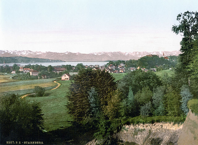
Штарнберг
Hiking in Штарнберг
Hiking in the Starnberg district, located in Bavaria, Germany, offers a beautiful blend of scenic landscapes, including lakes, forests, and picturesque villages. Here are some highlights and tips for hiking in the area:...
- Страна:
- Столица: Штарнберг
- Код автомобильного номера: WOR; STA
- Координаты: 48° 0' 36" N, 11° 16' 48" E
- GPS треки (wikiloc): [Ссылка]
- Высота над уровнем моря: 683 м m
- Площадь: 488.01 кв.км
- Население: 108887
- Веб сайт: [Ссылка]

Вайльхайм-Шонгау
- район Баварии
Hiking in Вайльхайм-Шонгау
Weilheim-Schongau, located in Bavaria, Germany, is a fantastic area for hiking enthusiasts. The region is characterized by its stunning landscapes, which include rolling hills, lush forests, and the picturesque foothills of the Alps. Here are some highlights and recommendations for hiking in this beautiful region:...
- Страна:
- Столица: Вайльхайм
- Код автомобильного номера: SOG; WM
- Координаты: 47° 49' 48" N, 11° 0' 0" E
- GPS треки (wikiloc): [Ссылка]
- Высота над уровнем моря: 647 м m
- Площадь: 966.22 кв.км
- Население: 106376
- Веб сайт: [Ссылка]


Гармиш-Партенкирхен
- район Баварии
Hiking in Гармиш-Партенкирхен
Garmisch-Partenkirchen is a beautiful district located in Bavaria, Germany, and is renowned for its stunning alpine scenery and outdoor recreational activities, making it a popular destination for hikers. Here are some key points about hiking in this picturesque area:...
- Страна:
- Столица: Гармиш-Партенкирхен
- Код автомобильного номера: GAP
- Координаты: 47° 34' 48" N, 11° 10' 12" E
- GPS треки (wikiloc): [Ссылка]
- Высота над уровнем моря: 1296 м m
- Площадь: 1012.00 кв.км
- Население: 78782
- Веб сайт: [Ссылка]

Мисбах
- район Баварии
Hiking in Мисбах
Miesbach is a scenic district located in Bavaria, Germany, known for its stunning landscapes, rolling hills, and proximity to the Alps. It offers a wealth of hiking opportunities for both beginners and experienced hikers. Here are some highlights about hiking in the Miesbach district:...
- Страна:
- Столица: Мисбах
- Код автомобильного номера: MB
- Координаты: 47° 44' 24" N, 11° 48' 36" E
- GPS треки (wikiloc): [Ссылка]
- Высота над уровнем моря: 741 м m
- Площадь: 864.00 кв.км
- Население: 93630
- Веб сайт: [Ссылка]

Мюнхен
- район Баварии
Hiking in Мюнхен
Hiking in and around Munich, the capital of Bavaria, offers a wonderful blend of urban landscapes and stunning natural scenery. While Munich itself is a vibrant city with parks and green spaces, many hiking opportunities are just a short distance away in the surrounding region....
- Страна:
- Столица: Мюнхен
- Телефонный код: 089
- Код автомобильного номера: WOR; M; AIB
- Координаты: 48° 0' 0" N, 11° 40' 12" E
- GPS треки (wikiloc): [Ссылка]
- Высота над уровнем моря: 513 м m
- Площадь: 52020.58 кв.км
- Население: 343405
- Веб сайт: [Ссылка]


Швац
Hiking in Швац
Hiking in the Schwaz District, located in Tyrol, Austria, offers stunning landscapes, varied terrain, and a rich cultural experience. The area is surrounded by the impressive mountain ranges of the Alps, making it a fantastic location for both casual hikers and experienced trekkers....
- Страна:

- Столица: Швац
- Код автомобильного номера: SZ
- Координаты: 47° 24' 0" N, 11° 48' 0" E
- GPS треки (wikiloc): [Ссылка]
- Высота над уровнем моря: 1676 м m
- Площадь: 1843 кв.км
- Население: 81841
- Веб сайт: [Ссылка]