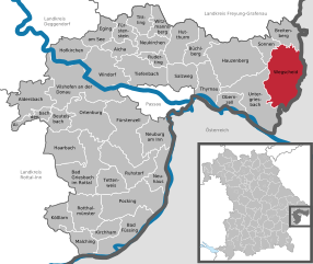
Коллершлаг (Kollerschlag, Kollerschlag)
 Hiking in Коллершлаг
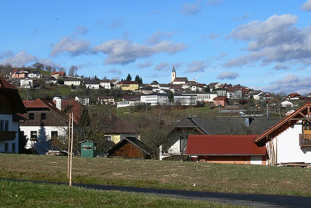
Kollerschlag, located in the beautiful region of Upper Austria, is a great spot for hiking enthusiasts. The area's picturesque landscapes, rolling hills, and lush forests provide a variety of trails suitable for all skill levels. Here are some highlights of hiking in Kollerschlag:
Trails and Routes
- Natural Trails: There are numerous well-marked hiking trails that wind through the scenic countryside, offering stunning views of the surrounding mountains and valleys.
- The Danube Trail: Not far from Kollerschlag, this trail follows the Danube River, providing a beautiful backdrop for a leisurely hike.
- Local Highlights: Trails often connect to local points of interest, such as historical sites, cultural landmarks, and unique natural formations.
Difficulty Levels
- Beginner to Intermediate: Many trails cater to beginners and those looking for a more relaxed hiking experience.
- Challenging Routes: For more experienced hikers, there are steeper and more challenging paths that offer a great workout and rewarding vistas.
Best Times to Hike
- Spring through Autumn: The best time for hiking in Kollerschlag is typically from spring to autumn, as the weather is milder, and the landscapes are vibrant and lush.
- Autumn Colors: Fall brings stunning foliage, making hikes particularly beautiful.
Tips for Hikers
- Stay Hydrated: Always carry enough water, especially during warmer months.
- Wear Appropriate Gear: Sturdy hiking boots and weather-appropriate clothing are essential.
- Respect Nature: Follow Leave No Trace principles to maintain the natural beauty of the area.
- Local Guides: Consider hiring a local guide or joining organized hikes to learn more about the area’s flora, fauna, and history.
Additional Activities
- Bird Watching: The area is home to diverse wildlife, making it an excellent spot for bird watching.
- Cycling: In addition to hiking, the region offers cycling routes for those who enjoy biking.
Kollerschlag is a gem for nature lovers and hikers, providing a peaceful retreat with opportunities for adventure and enjoyment of the great outdoors. Whether you're looking for a short stroll or a more vigorous hike, there is something for everyone in this charming region.
- Страна:

- Почтовый код: 4154
- Телефонный код: 07287
- Код автомобильного номера: RO
- Координаты: 48° 36' 21" N, 13° 50' 34" E


- GPS треки (wikiloc): [Ссылка]
- Высота над уровнем моря: 726 м m
- Площадь: 17 кв.км
- Население: 1520
- Веб сайт: http://www.kollerschlag.at
- Википедия русская: wiki(ru)
- Википедия английская: wiki(en)
- Википедия национальная: wiki(de)
- Хранилище Wikidata: Wikidata: Q257923
- Катеория в википедии: [Ссылка]
- код Freebase: [/m/03gvb6d]
- код GeoNames: Альт: [7872110]
- код VIAF: Альт: [249128381]
- код GND: Альт: [4321632-8]
- код австрийского муниципалитета: [41317]
Граничит с регионами:

Зарлайнсбах
Hiking in Зарлайнсбах
Sarleinsbach is a picturesque village located in the Mühlviertel region of Upper Austria, known for its stunning natural landscapes and excellent hiking opportunities. Here are some highlights about hiking in and around Sarleinsbach:...
- Страна:
- Почтовый код: 4152
- Телефонный код: 07283
- Код автомобильного номера: RO
- Координаты: 48° 32' 50" N, 13° 54' 19" E
- GPS треки (wikiloc): [Ссылка]
- Высота над уровнем моря: 561 м m
- Площадь: 37 кв.км
- Население: 2284
- Веб сайт: [Ссылка]

Вегшайд
Hiking in Вегшайд
Wegscheid, located in Bavaria, Germany, is a charming destination for hiking enthusiasts. The area is characterized by its picturesque landscapes, including rolling hills, lush forests, and panoramic views of the surrounding region. Here are some highlights and tips for hiking in Wegscheid:...
- Страна:

- Почтовый код: 94110; W-8396; 8396
- Телефонный код: 08592
- Координаты: 48° 36' 0" N, 13° 47' 0" E
- GPS треки (wikiloc): [Ссылка]
- Высота над уровнем моря: 718 м m
- Площадь: 80.64 кв.км
- Население: 5393
- Веб сайт: [Ссылка]
Небельберг
Hiking in Небельберг
Nebelberg is a picturesque destination in the heart of Austria that offers a variety of hiking opportunities for enthusiasts of all levels. Nestled in the region of Upper Austria, this area is characterized by stunning landscapes, lush forests, rolling hills, and charming villages....
- Страна:
- Почтовый код: 4155
- Телефонный код: 07287
- Код автомобильного номера: RO
- Координаты: 48° 37' 44" N, 13° 50' 51" E
- GPS треки (wikiloc): [Ссылка]
- Высота над уровнем моря: 695 м m
- Площадь: 9.15 кв.км
- Население: 632
- Веб сайт: [Ссылка]
Пайльштайн-им-Мюльфиртель
Hiking in Пайльштайн-им-Мюльфиртель
Peilstein im Mühlviertel is a charming village in the Mühlviertel region of Austria, surrounded by beautiful landscapes that offer numerous hiking opportunities. The area is characterized by its rolling hills, dense forests, and picturesque views of the Danube Valley....
- Страна:
- Почтовый код: 4153
- Телефонный код: 07287
- Код автомобильного номера: RO
- Координаты: 48° 37' 6" N, 13° 53' 41" E
- GPS треки (wikiloc): [Ссылка]
- Высота над уровнем моря: 584 м m
- Площадь: 23 кв.км
- Население: 1541
- Веб сайт: [Ссылка]

Оберкаппель
Hiking in Оберкаппель
Oberkappel is a picturesque village located in the Mühlviertel region of Upper Austria. Known for its stunning natural surroundings, Oberkappel is a great destination for hiking enthusiasts. Here are some highlights and tips for hiking in this area:...
- Страна:
- Почтовый код: 4144
- Телефонный код: 07284
- Код автомобильного номера: RO
- Координаты: 48° 33' 11" N, 13° 46' 17" E
- GPS треки (wikiloc): [Ссылка]
- Высота над уровнем моря: 511 м m
- Площадь: 12 кв.км
- Население: 725
- Веб сайт: [Ссылка]