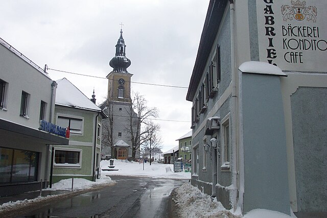
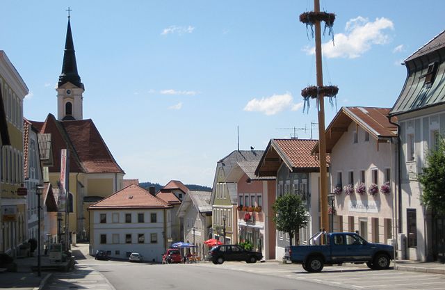
Вегшайд (Wegscheid, Wegscheid)

 Hiking in Вегшайд
Wegscheid, located in Bavaria, Germany, is a charming destination for hiking enthusiasts. The area is characterized by its picturesque landscapes, including rolling hills, lush forests, and panoramic views of the surrounding region. Here are some highlights and tips for hiking in Wegscheid:
Trails
- Trail Variety: Wegscheid offers a range of trails that cater to different skill levels, from easy walks suitable for families to more challenging routes for experienced hikers.
- Scenic Routes: Many trails wind through beautiful natural areas, providing opportunities to enjoy the local flora and fauna. Some trails may also lead to historical sites or viewpoints.
- Marked Paths: The hiking paths are generally well-marked. Always look for signs indicating directions and trail difficulties.
Highlights
- Nature Reserves: The surrounding nature reserves and parks provide excellent opportunities for wildlife observation and photography.
- Local Culture: Some trails may take you through quaint villages or historical sites, allowing you to experience local Bavarian culture.
- Seasonal Beauty: Each season offers unique experiences, from vibrant spring blooms to autumn foliage.
Tips for Hiking in Wegscheid
- Weather Preparedness: Check the weather forecast before setting out, and dress in layers to adapt to changing conditions.
- Hydration & Snacks: Carry enough water and snacks, especially on longer hikes, as facilities may be sparse.
- Navigation Tools: A good map or GPS device is useful, especially if you venture off the main paths.
- Safety First: Always hike with a buddy if possible, let someone know your plans, and carry a fully charged phone for emergencies.
Best Times to Hike
- Spring and Autumn: These seasons are ideal for hiking, thanks to mild temperatures and beautiful scenery.
- Summer: Though it can be warmer, early morning or late afternoon hikes can help avoid the heat.
Whether you're a local or a visitor, hiking in Wegscheid can be a rewarding experience that allows you to connect with nature and enjoy the stunning Bavarian landscape. Always respect the environment and follow local guidelines to keep these beautiful areas preserved for future generations. Happy hiking!
- Страна:

- Почтовый код: 94110; W-8396; 8396
- Телефонный код: 08592
- Координаты: 48° 36' 0" N, 13° 47' 0" E


- GPS треки (wikiloc): [Ссылка]
- Высота над уровнем моря: 718 м m
- Площадь: 80.64 кв.км
- Население: 5393
- Веб сайт: http://www.wegscheid.de
- Википедия русская: wiki(ru)
- Википедия английская: wiki(en)
- Википедия национальная: wiki(de)
- Хранилище Wikidata: Wikidata: Q530378
- Катеория в википедии: [Ссылка]
- код Freebase: [/m/02rfqt7]
- код GeoNames: Альт: [2813344]
- код VIAF: Альт: [157578030]
- ID отношения в OpenStreetMap: [958088]
- код GND: Альт: [4064971-4]
- идентификатор местоположения ArchINFORM: [6907]
- код LCNAF: Альт: [nr2004027854]
- место в MusicBrainz: [1cfa1463-3b98-4243-bb69-5ff30d8fa3f1]
- код Historical Gazetteer: [WEGEI1JN68VO]
- Bavarikon ID: [ODB_A00001581]
- идентификатор муниципалитетов в Германии: 09275156
Граничит с регионами:


Хауценберг
Hiking in Хауценберг
Hauzenberg, located in Bavaria, Germany, offers a variety of beautiful hiking trails that showcase the stunning natural landscapes of the region. Nestled in the foothills of the Bavarian Forest, Hauzenberg is known for its lush forests, rolling hills, and picturesque views. Here are some key points about hiking in Hauzenberg:...
- Страна:
- Почтовый код: 94051; W-8395; 8391; 8395
- Телефонный код: 08586
- Код автомобильного номера: PA
- Координаты: 48° 39' 6" N, 13° 37' 25" E
- GPS треки (wikiloc): [Ссылка]
- Высота над уровнем моря: 546 м m
- Площадь: 82.80 кв.км
- Население: 11857
- Веб сайт: [Ссылка]
Коллершлаг
Hiking in Коллершлаг
Kollerschlag, located in the beautiful region of Upper Austria, is a great spot for hiking enthusiasts. The area's picturesque landscapes, rolling hills, and lush forests provide a variety of trails suitable for all skill levels. Here are some highlights of hiking in Kollerschlag:...
- Страна:

- Почтовый код: 4154
- Телефонный код: 07287
- Код автомобильного номера: RO
- Координаты: 48° 36' 21" N, 13° 50' 34" E
- GPS треки (wikiloc): [Ссылка]
- Высота над уровнем моря: 726 м m
- Площадь: 17 кв.км
- Население: 1520
- Веб сайт: [Ссылка]


Зоннен
Hiking in Зоннен
Hiking in Sonnen, a small municipality in the Bavaria region of Germany, offers a variety of beautiful trails and scenic views. The area around Sonnen is characterized by rolling hills, lush forests, and picturesque countryside, making it an ideal destination for hikers of all experience levels....
- Страна:
- Почтовый код: 94164; W-8391; 8391
- Телефонный код: 08584
- Код автомобильного номера: PA
- Координаты: 48° 41' 5" N, 13° 43' 25" E
- GPS треки (wikiloc): [Ссылка]
- Высота над уровнем моря: 836 м m
- Площадь: 16.50 кв.км
- Население: 1367
- Веб сайт: [Ссылка]


Брайтенберг
Hiking in Брайтенберг
Breitenberg, located in Lower Bavaria, is a fantastic destination for hiking enthusiasts. The region features a mix of scenic landscapes, charming villages, and diverse flora and fauna, making it ideal for both casual hikers and experienced trekkers....
- Страна:
- Почтовый код: 94139
- Телефонный код: 08584
- Код автомобильного номера: PA
- Координаты: 48° 42' 14" N, 13° 47' 39" E
- GPS треки (wikiloc): [Ссылка]
- Высота над уровнем моря: 689 м m
- Площадь: 29.87 кв.км
- Население: 2109
- Веб сайт: [Ссылка]

Унтергрисбах
Hiking in Унтергрисбах
Untergriesbach, located in Bavaria, Germany, is a charming area surrounded by beautiful natural landscapes, making it an excellent destination for hiking enthusiasts. Here are some key points about hiking in and around Untergriesbach:...
- Страна:
- Почтовый код: 94107; W-8391; 8391
- Телефонный код: 08593
- Код автомобильного номера: PA
- Координаты: 48° 34' 25" N, 13° 40' 2" E
- GPS треки (wikiloc): [Ссылка]
- Высота над уровнем моря: 556 м m
- Площадь: 73.61 кв.км
- Население: 5814
- Веб сайт: [Ссылка]
Небельберг
Hiking in Небельберг
Nebelberg is a picturesque destination in the heart of Austria that offers a variety of hiking opportunities for enthusiasts of all levels. Nestled in the region of Upper Austria, this area is characterized by stunning landscapes, lush forests, rolling hills, and charming villages....
- Страна:
- Почтовый код: 4155
- Телефонный код: 07287
- Код автомобильного номера: RO
- Координаты: 48° 37' 44" N, 13° 50' 51" E
- GPS треки (wikiloc): [Ссылка]
- Высота над уровнем моря: 695 м m
- Площадь: 9.15 кв.км
- Население: 632
- Веб сайт: [Ссылка]

Нойстифт
Hiking in Нойстифт
Neustift im Mühlkreis, located in the picturesque Mühlviertel region of Austria, offers a variety of hiking opportunities that cater to all levels of hikers. This area is known for its beautiful natural landscapes, rolling hills, dense forests, and stunning views of the surrounding countryside....
- Страна:
- Почтовый код: 4143
- Телефонный код: 07284
- Код автомобильного номера: RO
- Координаты: 48° 31' 44" N, 13° 45' 22" E
- GPS треки (wikiloc): [Ссылка]
- Высота над уровнем моря: 591 м m
- Площадь: 20 кв.км
- Население: 1461
- Веб сайт: [Ссылка]
Юльбах
- коммуна в федеральной земле Верхняя Австрия, Австрия
Hiking in Юльбах
Julbach, a picturesque village in the Austrian region of Upper Austria, offers a variety of hiking opportunities that showcase the stunning landscapes of the Bohemian Forest (Böhmerwald) and the surrounding areas. Here’s an overview of what you can expect when hiking in Julbach:...
- Страна:
- Почтовый код: 4162
- Телефонный код: 07288
- Код автомобильного номера: RO
- Координаты: 48° 39' 32" N, 13° 52' 5" E
- GPS треки (wikiloc): [Ссылка]
- Высота над уровнем моря: 589 м m
- Площадь: 22 кв.км
- Население: 1537
- Веб сайт: [Ссылка]

Оберкаппель
Hiking in Оберкаппель
Oberkappel is a picturesque village located in the Mühlviertel region of Upper Austria. Known for its stunning natural surroundings, Oberkappel is a great destination for hiking enthusiasts. Here are some highlights and tips for hiking in this area:...
- Страна:
- Почтовый код: 4144
- Телефонный код: 07284
- Код автомобильного номера: RO
- Координаты: 48° 33' 11" N, 13° 46' 17" E
- GPS треки (wikiloc): [Ссылка]
- Высота над уровнем моря: 511 м m
- Площадь: 12 кв.км
- Население: 725
- Веб сайт: [Ссылка]