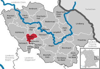
Колльнбург (Kollnburg, Kollnburg)

 Hiking in Колльнбург
Kollnburg, located in the Bavarian Forest of Germany, is a charming destination for hiking enthusiasts. The region is characterized by its stunning natural beauty, dense forests, rolling hills, and picturesque landscapes, making it ideal for outdoor activities.
Hiking Trails in Kollnburg
-
Marked Trails: Kollnburg offers a variety of well-marked hiking trails that cater to different fitness levels. Some popular routes include:
- The Kollnburg Circular Trail: This trail takes you around the village, providing views of the local countryside and opportunities to explore nearby forests.
- Drachenfels (Dragon Rock) Trail: A moderate hike that leads to an impressive viewpoint offering panoramic views of the Bavarian Forest.
-
Nature Reserves: The area around Kollnburg has nature reserves that feature diverse flora and fauna, making it a great place for nature lovers. Hikers often enjoy birdwatching and photography along the trails.
-
Scenic Views: Many trails in the region offer scenic viewpoints where you can take a break and enjoy the breathtaking vistas of the surrounding hills and valleys.
Best Time to Hike
The best seasons for hiking in Kollnburg are late spring, summer, and early fall when the weather is mild and the trails are accessible. Each season offers a unique experience; in spring, you can see blooming flowers, while in autumn, the foliage becomes a beautiful array of colors.
Tips for Hiking in Kollnburg
- Weather Preparedness: Always check the weather conditions before heading out. The Bavarian Forest can experience sudden changes in weather.
- Equipment: Wear appropriate hiking footwear and clothing. A good pair of hiking boots is essential for navigating uneven terrain.
- Stay Hydrated: Make sure to carry enough water and snacks, especially if you're planning a longer hike.
- Local Maps: While trails are generally well-marked, having a local map or GPS can be helpful, especially for less frequented paths.
- Respect the Environment: Follow the Leave No Trace principles to protect the natural beauty of the area.
Accessing Kollnburg
Kollnburg is accessible by car and is well-connected to the rest of Bavaria. If you're using public transport, check local train and bus schedules to reach the village.
Whether you're an experienced hiker or a beginner, Kollnburg and its surrounding areas provide a wonderful setting to immerse yourself in nature and enjoy the peace of the Bavarian Forest. Happy hiking!
- Страна:

- Почтовый код: 94262
- Телефонный код: 09942
- Код автомобильного номера: REG
- Координаты: 49° 3' 0" N, 12° 52' 0" E


- GPS треки (wikiloc): [Ссылка]
- Высота над уровнем моря: 655 м m
- Площадь: 59.53 кв.км
- Население: 2789
- Веб сайт: http://www.kollnburg.de
- Википедия русская: wiki(ru)
- Википедия английская: wiki(en)
- Википедия национальная: wiki(de)
- Хранилище Wikidata: Wikidata: Q488636
- Катеория в википедии: [Ссылка]
- код Freebase: [/m/02q78rb]
- код GeoNames: Альт: [2886285]
- код VIAF: Альт: [130305591]
- ID отношения в OpenStreetMap: [959176]
- код GND: Альт: [4264935-3]
- код LCNAF: Альт: [n89146885]
- код Historical Gazetteer: [KOLUR1JN69KB]
- Bavarikon ID: [ODB_A00001597]
- идентификатор муниципалитетов в Германии: 09276128
Граничит с регионами:


Фихтах
Hiking in Фихтах
Viechtach, located in Bavaria, Germany, is surrounded by the natural beauty of the Bavarian Forest, making it a fantastic destination for hiking enthusiasts. Here are some key points to consider if you're planning a hiking trip in Viechtach:...
- Страна:
- Почтовый код: 94234
- Телефонный код: 09942
- Координаты: 49° 4' 45" N, 12° 53' 5" E
- GPS треки (wikiloc): [Ссылка]
- Высота над уровнем моря: 450 м m
- Площадь: 62.47 кв.км
- Население: 8012
- Веб сайт: [Ссылка]

Патерсдорф
Hiking in Патерсдорф
Patersdorf is a picturesque village located in Bavaria, Germany, known for its beautiful natural landscapes, making it an excellent location for hiking enthusiasts. Nestled near the edge of the Bavarian Forest National Park, Patersdorf offers a variety of trails that cater to different skill levels, from leisurely walks to more challenging hikes....
- Страна:
- Почтовый код: 94265
- Телефонный код: 09923
- Код автомобильного номера: REG
- Координаты: 49° 1' 0" N, 12° 59' 0" E
- GPS треки (wikiloc): [Ссылка]
- Высота над уровнем моря: 503 м m
- Площадь: 17.04 кв.км
- Население: 1699
- Веб сайт: [Ссылка]