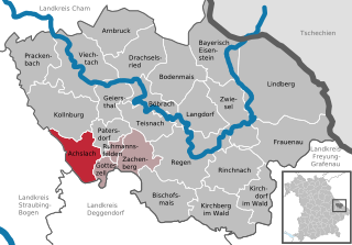
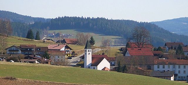
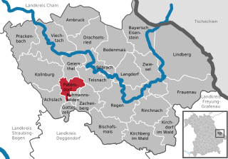
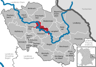
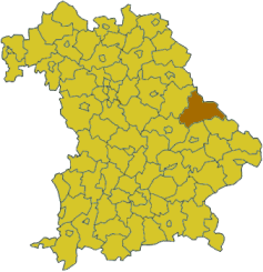
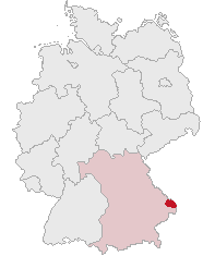
Реген (Regen district, Landkreis Regen)

 Hiking in Реген
Hiking in the Regen district, located in Bavaria, Germany, offers a stunning blend of natural beauty, cultural attractions, and outdoor adventure. The region is known for its picturesque landscapes, featuring lush forests, rolling hills, and the scenic Danube and Regen rivers. Here are some highlights and tips for hiking in this area:
Trails and Scenery
-
The Bavarian Forest National Park: This park is nearby and offers a variety of hiking trails that cater to all skill levels. You can explore diverse ecosystems, including dense forests, wetlands, and mountain peaks. The Goldsteig Trail traverses parts of this area and is one of the longest premium hiking trails in Germany.
-
Local Trails: Numerous hiking paths wind through the Regen district, including routes that pass through charming villages and historical landmarks. Many trails are well-marked, and local tourism offices provide maps and information.
-
Panoramic Views: Some trails lead to lookout points that provide breathtaking views of the surrounding countryside. The view from the peaks of the European watershed covers both the Danube and Elbe river basins, which is quite unique.
Nature and Wildlife
The region is home to a variety of flora and fauna, including deer, wild boar, and numerous bird species. Hikers should keep an eye out for the rich biodiversity as they explore the trails.
Seasonal Considerations
- Spring and Summer: Ideal for hiking, with mild temperatures and blooming wildflowers. Be sure to bring plenty of water and sun protection, as some trails can be quite exposed.
- Fall: A beautiful time to hike, with vibrant autumn colors. It’s advisable to check trail conditions, especially after rain.
- Winter: Some trails may be accessible for winter hiking or snowshoeing, but it's essential to check local conditions and carry the appropriate gear.
Amenities
The towns in the Regen district, like Regen and other small villages, offer various amenities, including accommodations, restaurants, and shops. You can enjoy local Bavarian cuisine and hospitality after a day on the trails.
Tips for Hiking in Regen
- Plan Ahead: Check trail maps, weather conditions, and difficulty levels before setting out.
- Gear Up: Wear appropriate footwear and clothing for the season. A good pair of hiking boots and layering system will ensure comfort.
- Stay Hydrated: Always carry enough water with you, as well as snacks for energy.
- Respect Nature: Follow the Leave No Trace principles to preserve the natural beauty of the trails.
Whether you're a seasoned hiker or a casual walker, the Regen district offers a wonderful experience for anyone eager to explore the beauty of Bavarian nature.
- Страна:

- Столица: Реген
- Код автомобильного номера: REG
- Координаты: 49° 0' 0" N, 13° 10' 12" E


- GPS треки (wikiloc): [Ссылка]
- Высота над уровнем моря: 686 м m
- Площадь: 975.00 кв.км
- Население: 76135
- Веб сайт: http://www.landkreis-regen.de/
- Википедия русская: wiki(ru)
- Википедия английская: wiki(en)
- Википедия национальная: wiki(de)
- Хранилище Wikidata: Wikidata: Q10483
- Катеория в википедии: [Ссылка]
- код Freebase: [/m/02bhpv]
- код GeoNames: Альт: [3220814]
- код VIAF: Альт: [234134292]
- ID отношения в OpenStreetMap: [62709]
- код GND: Альт: [4048974-7]
- идентификатор местоположения ArchINFORM: [2577]
- код TGN: [7077304]
- код Historical Gazetteer: [adm_139276]
- Bavarikon ID: [ODB_A00002380]
- код NUTS: [DE229]
- код района Германии: 09276
Включает регионы:


Цахенберг
Hiking in Цахенберг
Zachenberg, located in Bavaria, Germany, is a beautiful destination for hiking enthusiasts. Surrounded by picturesque landscapes, lush forests, and rolling hills, it's an excellent place to explore nature and enjoy outdoor activities....
- Страна:
- Почтовый код: 94239
- Телефонный код: 09929
- Код автомобильного номера: REG
- Координаты: 48° 58' 0" N, 13° 0' 0" E
- GPS треки (wikiloc): [Ссылка]
- Высота над уровнем моря: 602 м m
- Площадь: 27.29 кв.км
- Население: 2046
- Веб сайт: [Ссылка]


Цвизель
- община Германии
Hiking in Цвизель
Zwiesel, located in Bavaria, Germany, is a beautiful town nestled at the edge of the Bavarian Forest National Park. It offers a variety of hiking opportunities that cater to different skill levels, making it a great destination for both novice and experienced hikers....
- Страна:
- Почтовый код: 94227
- Телефонный код: 9922
- Код автомобильного номера: REG
- Координаты: 49° 1' 0" N, 13° 14' 0" E
- GPS треки (wikiloc): [Ссылка]
- Высота над уровнем моря: 750 м m
- Площадь: 41.16 кв.км
- Население: 9407
- Веб сайт: [Ссылка]


Фихтах
Hiking in Фихтах
Viechtach, located in Bavaria, Germany, is surrounded by the natural beauty of the Bavarian Forest, making it a fantastic destination for hiking enthusiasts. Here are some key points to consider if you're planning a hiking trip in Viechtach:...
- Страна:
- Почтовый код: 94234
- Телефонный код: 09942
- Координаты: 49° 4' 45" N, 12° 53' 5" E
- GPS треки (wikiloc): [Ссылка]
- Высота над уровнем моря: 450 м m
- Площадь: 62.47 кв.км
- Население: 8012
- Веб сайт: [Ссылка]

Акслах
Hiking in Акслах
Achslach is a beautiful area located in Bavaria, Germany, known for its stunning natural landscapes, dense forests, and scenic hiking trails. Here are some highlights and tips for hiking in and around Achslach:...
- Страна:
- Почтовый код: 94250
- Телефонный код: 09929
- Код автомобильного номера: REG
- Координаты: 48° 58' 18" N, 12° 56' 6" E
- GPS треки (wikiloc): [Ссылка]
- Высота над уровнем моря: 595 м m
- Площадь: 30.05 кв.км
- Население: 1083
- Веб сайт: [Ссылка]


Тайснах
Hiking in Тайснах
Teisnach is a charming town located in the Bavarian Forest of Germany, known for its beautiful landscapes and outdoor recreational opportunities, including hiking. Here are some highlights and tips for hiking in the Teisnach area:...
- Страна:
- Почтовый код: 94244
- Телефонный код: 09923
- Код автомобильного номера: REG
- Координаты: 49° 2' 0" N, 13° 0' 0" E
- GPS треки (wikiloc): [Ссылка]
- Высота над уровнем моря: 478 м m
- Площадь: 25.77 кв.км
- Население: 2641
- Веб сайт: [Ссылка]

Колльнбург
Hiking in Колльнбург
Kollnburg, located in the Bavarian Forest of Germany, is a charming destination for hiking enthusiasts. The region is characterized by its stunning natural beauty, dense forests, rolling hills, and picturesque landscapes, making it ideal for outdoor activities....
- Страна:
- Почтовый код: 94262
- Телефонный код: 09942
- Код автомобильного номера: REG
- Координаты: 49° 3' 0" N, 12° 52' 0" E
- GPS треки (wikiloc): [Ссылка]
- Высота над уровнем моря: 655 м m
- Площадь: 59.53 кв.км
- Население: 2789
- Веб сайт: [Ссылка]

Ринхнах
Hiking in Ринхнах
Rinchnach is a charming village located in Bavaria, Germany, that's known for its beautiful landscapes and outdoor activities, particularly hiking. Nestled in the heart of the Bavarian Forest, Rinchnach offers a range of hiking trails suitable for various skill levels....
- Страна:
- Почтовый код: 94269
- Телефонный код: 09921
- Код автомобильного номера: REG
- Координаты: 48° 57' 0" N, 13° 12' 0" E
- GPS треки (wikiloc): [Ссылка]
- Высота над уровнем моря: 564 м m
- Площадь: 40.21 кв.км
- Население: 2988
- Веб сайт: [Ссылка]

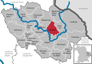
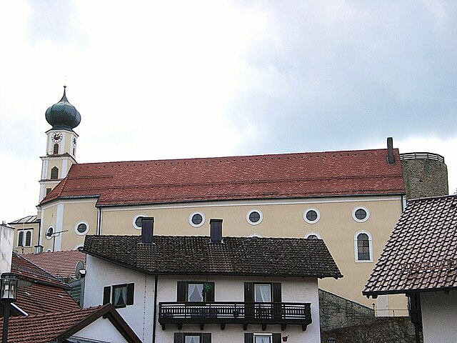
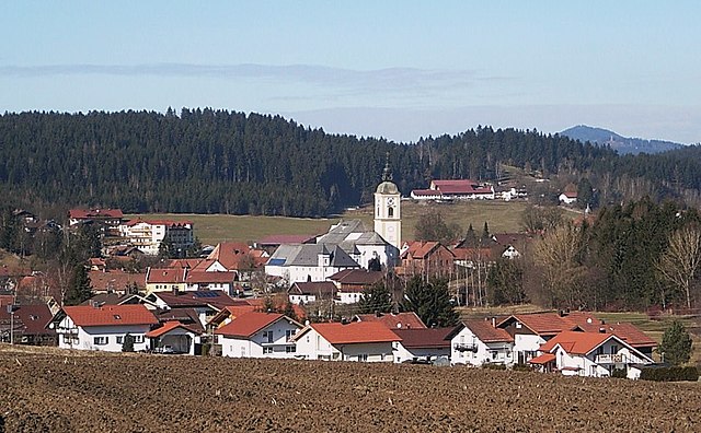
Лангдорф
Hiking in Лангдорф
Langdorf, located in Bavaria, Germany, is surrounded by beautiful natural landscapes that make it an excellent destination for hiking enthusiasts. Here are some key points to consider if you're planning to hike in and around Langdorf:...
- Страна:
- Почтовый код: 94264
- Телефонный код: 09921
- Код автомобильного номера: REG
- Координаты: 49° 1' 0" N, 13° 9' 0" E
- GPS треки (wikiloc): [Ссылка]
- Высота над уровнем моря: 645 м m
- Площадь: 34.35 кв.км
- Население: 1779
- Веб сайт: [Ссылка]

Гайерсталь
Hiking in Гайерсталь
Geiersthal is a picturesque area in Germany, known for its stunning natural landscapes, making it an attractive destination for hiking enthusiasts. While specific trails in Geiersthal may not be as widely documented as those in larger national parks, there are several features that make the region appealing for hikers:...
- Страна:
- Почтовый код: 94244
- Телефонный код: 09923
- Код автомобильного номера: REG
- Координаты: 49° 3' 0" N, 12° 59' 0" E
- GPS треки (wikiloc): [Ссылка]
- Высота над уровнем моря: 505 м m
- Площадь: 22.37 кв.км
- Население: 2085
- Веб сайт: [Ссылка]


Линдберг
Hiking in Линдберг
Lindberg, a picturesque village in Bavaria, Germany, is situated near the stunning Bavarian Forest National Park, making it an excellent destination for hikers of all levels. The region is known for its lush landscapes, dense forests, and diverse wildlife, offering a serene backdrop for outdoor activities....
- Страна:
- Почтовый код: 94227
- Телефонный код: 09922
- Код автомобильного номера: REG
- Координаты: 49° 2' 0" N, 13° 15' 0" E
- GPS треки (wikiloc): [Ссылка]
- Высота над уровнем моря: 649 м m
- Площадь: 108.84 кв.км
- Население: 2296
- Веб сайт: [Ссылка]

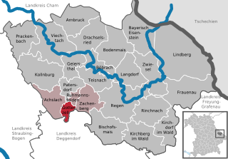
Готтесцелль
Hiking in Готтесцелль
Gotteszell, located in the Bavarian Forest of Germany, is a charming destination for hiking enthusiasts. The area is characterized by its lush forests, rolling hills, and stunning panoramic views, making it ideal for outdoor activities. Here’s a brief overview of what to expect while hiking in Gotteszell:...
- Страна:
- Почтовый код: 94239
- Телефонный код: 09929
- Код автомобильного номера: REG
- Координаты: 48° 58' 0" N, 12° 58' 0" E
- GPS треки (wikiloc): [Ссылка]
- Высота над уровнем моря: 510 м m
- Площадь: 9.22 кв.км
- Население: 1167
- Веб сайт: [Ссылка]


Фрауэнау
Hiking in Фрауэнау
Frauenau is a picturesque village located in the Bavarian Forest in Germany, known for its beautiful landscapes and numerous hiking trails. The region is characterized by dense forests, rolling hills, and stunning views, making it a perfect destination for outdoor enthusiasts....
- Страна:
- Почтовый код: 94258
- Телефонный код: 09926
- Код автомобильного номера: REG
- Координаты: 48° 59' 0" N, 13° 18' 0" E
- GPS треки (wikiloc): [Ссылка]
- Высота над уровнем моря: 616 м m
- Площадь: 60.1 кв.км
- Население: 2697
- Веб сайт: [Ссылка]

Патерсдорф
Hiking in Патерсдорф
Patersdorf is a picturesque village located in Bavaria, Germany, known for its beautiful natural landscapes, making it an excellent location for hiking enthusiasts. Nestled near the edge of the Bavarian Forest National Park, Patersdorf offers a variety of trails that cater to different skill levels, from leisurely walks to more challenging hikes....
- Страна:
- Почтовый код: 94265
- Телефонный код: 09923
- Код автомобильного номера: REG
- Координаты: 49° 1' 0" N, 12° 59' 0" E
- GPS треки (wikiloc): [Ссылка]
- Высота над уровнем моря: 503 м m
- Площадь: 17.04 кв.км
- Население: 1699
- Веб сайт: [Ссылка]


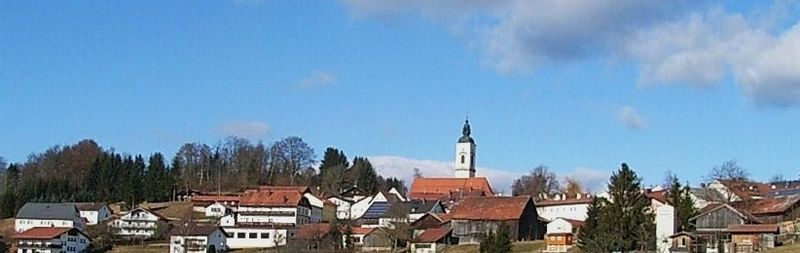
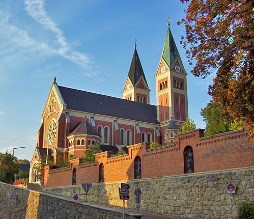
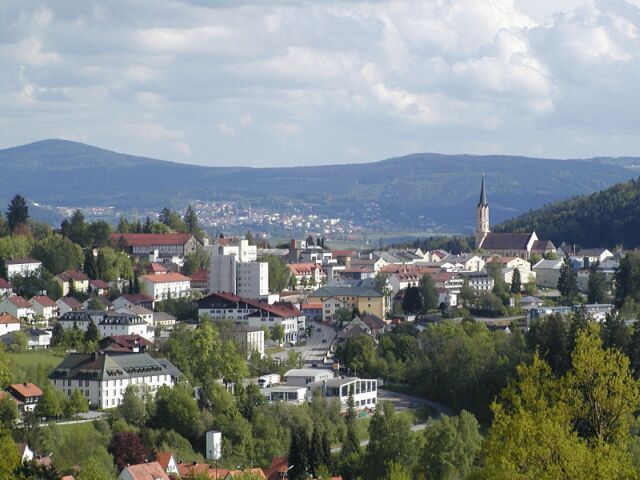
Реген
Hiking in Реген
Regen, situated in Bavaria, Germany, is a beautiful area known for its stunning landscapes and natural beauty, making it a great destination for hiking enthusiasts. Here are some important aspects to consider when hiking in and around Regen:...
- Страна:
- Почтовый код: 94209
- Телефонный код: 09922; 09921
- Код автомобильного номера: REG
- Координаты: 48° 58' 12" N, 13° 7' 35" E
- GPS треки (wikiloc): [Ссылка]
- Высота над уровнем моря: 532 м m
- Площадь: 65.14 кв.км
- Население: 10655
- Веб сайт: [Ссылка]


Румансфельден
Hiking in Румансфельден
Ruhmannsfelden, a picturesque town in Bavaria, Germany, offers an array of scenic hiking opportunities for outdoor enthusiasts. Nestled in the heart of the Bavarian Forest, the region is characterized by its beautiful landscapes, lush forests, and rolling hills. Here’s what you can expect when hiking in and around Ruhmannsfelden:...
- Страна:
- Почтовый код: 94239
- Телефонный код: 09929
- Код автомобильного номера: REG
- Координаты: 48° 59' 0" N, 12° 59' 0" E
- GPS треки (wikiloc): [Ссылка]
- Высота над уровнем моря: 536 м m
- Площадь: 5.8 кв.км
- Население: 1972
- Веб сайт: [Ссылка]


Драксельсрид
Hiking in Драксельсрид
Drachselsried is a picturesque village located in the Bavarian Forest of Germany, known for its stunning natural landscapes and excellent hiking opportunities. Here are some key points about hiking in Drachselsried:...
- Страна:
- Почтовый код: 94256
- Телефонный код: 09945
- Код автомобильного номера: REG
- Координаты: 49° 6' 0" N, 13° 1' 0" E
- GPS треки (wikiloc): [Ссылка]
- Высота над уровнем моря: 648 м m
- Площадь: 41.72 кв.км
- Население: 2270
- Веб сайт: [Ссылка]

Кирхдорф-им-Вальд
Hiking in Кирхдорф-им-Вальд
Kirchdorf im Wald is a charming village located in the Bavarian region of Germany, known for its beautiful natural landscapes and outdoor activities, particularly hiking. The area offers a variety of hiking trails suitable for different skill levels, making it a great destination for both novice and experienced hikers....
- Страна:
- Почтовый код: 94261
- Телефонный код: 09928
- Код автомобильного номера: REG
- Координаты: 48° 55' 0" N, 13° 16' 0" E
- GPS треки (wikiloc): [Ссылка]
- Высота над уровнем моря: 684 м m
- Площадь: 30.55 кв.км
- Население: 2054
- Веб сайт: [Ссылка]


Кирхберг-им-Вальд
Hiking in Кирхберг-им-Вальд
Kirchberg im Wald, located in Bavaria, Germany, is a charming destination for outdoor enthusiasts, particularly those who enjoy hiking. The area is surrounded by beautiful natural landscapes, including rolling hills, dense forests, and picturesque meadows, making it an ideal spot for various hiking trails....
- Страна:
- Почтовый код: 94259
- Телефонный код: 09927
- Код автомобильного номера: REG
- Координаты: 48° 54' 0" N, 13° 11' 0" E
- GPS треки (wikiloc): [Ссылка]
- Высота над уровнем моря: 880 м m
- Площадь: 48.79 кв.км
- Население: 3969
- Веб сайт: [Ссылка]


Арнбрук
Hiking in Арнбрук
Arnbruck is a picturesque village located in the Bavarian Forest of Germany, offering a variety of hiking opportunities for outdoor enthusiasts. The region is known for its stunning landscapes, diverse flora and fauna, and well-marked trails that cater to different skill levels. Here are some key points to consider when hiking in Arnbruck:...
- Страна:
- Почтовый код: 93471
- Телефонный код: 09945
- Код автомобильного номера: REG
- Координаты: 49° 7' 48" N, 12° 59' 54" E
- GPS треки (wikiloc): [Ссылка]
- Высота над уровнем моря: 571 м m
- Площадь: 37.87 кв.км
- Население: 1860
- Веб сайт: [Ссылка]


Бишофсмайс
Hiking in Бишофсмайс
Bischofsmais is a charming village located in the Bavarian Forest in Germany, making it an excellent destination for hiking enthusiasts. The region is characterized by its lush forests, rolling hills, and stunning views, offering a variety of trails suitable for different skill levels....
- Страна:
- Почтовый код: 94253
- Телефонный код: 09920
- Код автомобильного номера: REG
- Координаты: 48° 55' 0" N, 13° 5' 0" E
- GPS треки (wikiloc): [Ссылка]
- Высота над уровнем моря: 682 м m
- Площадь: 46.28 кв.км
- Население: 3009
- Веб сайт: [Ссылка]


Байериш-Айзенштайн
Hiking in Байериш-Айзенштайн
Bayerisch Eisenstein, located in the Bavarian Forest National Park in Germany, is a fantastic destination for hiking enthusiasts. The area is known for its stunning landscapes, diverse flora and fauna, and a wide range of hiking trails suitable for different skill levels....
- Страна:
- Почтовый код: 94252
- Телефонный код: 09925
- Код автомобильного номера: REG
- Координаты: 49° 7' 12" N, 13° 12' 0" E
- GPS треки (wikiloc): [Ссылка]
- Высота над уровнем моря: 724 м m
- Площадь: 47.32 кв.км
- Население: 1007
- Веб сайт: [Ссылка]


Праккенбах
Hiking in Праккенбах
Prackenbach, located in Bavaria, Germany, offers a variety of hiking opportunities that cater to different skill levels. Nestled amidst picturesque landscapes, you'll find beautifully maintained trails that lead through lush forests, rolling hills, and scenic views of the surrounding countryside....
- Страна:
- Почтовый код: 94267
- Телефонный код: 09942
- Код автомобильного номера: REG
- Координаты: 49° 6' 0" N, 12° 50' 0" E
- GPS треки (wikiloc): [Ссылка]
- Высота над уровнем моря: 496 м m
- Площадь: 40.08 кв.км
- Население: 2476
- Веб сайт: [Ссылка]

Бёбрах
Hiking in Бёбрах
Böbrach, a charming village located in Bavaria, Germany, offers a serene setting for outdoor enthusiasts, particularly hikers. Surrounded by the picturesque landscapes of the Bavarian Forest, Böbrach provides access to numerous trails that cater to different skill levels....
- Страна:
- Почтовый код: 94255
- Телефонный код: 09923
- Код автомобильного номера: REG
- Координаты: 49° 4' 0" N, 13° 2' 0" E
- GPS треки (wikiloc): [Ссылка]
- Высота над уровнем моря: 576 м m
- Площадь: 27.55 кв.км
- Население: 1518
- Веб сайт: [Ссылка]
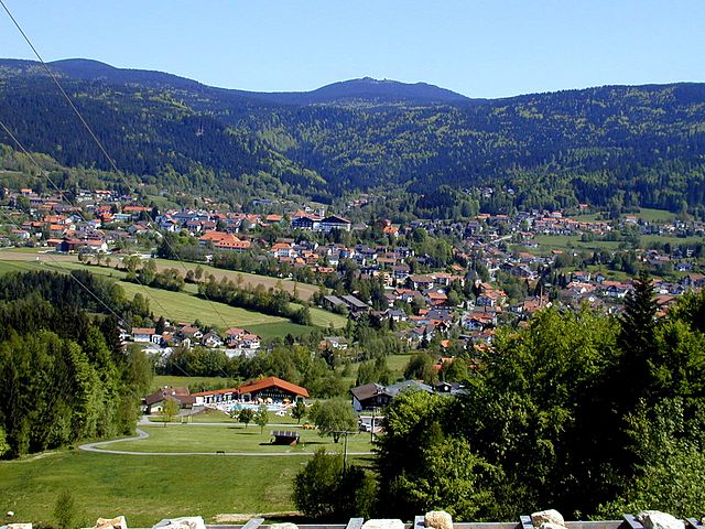

Боденмайс
Hiking in Боденмайс
Bodenmais is a charming village located in the Bavarian Forest region of Germany, known for its stunning natural landscapes and extensive hiking trails. Here are some key details about hiking in Bodenmais:...
- Страна:
- Почтовый код: 94249
- Телефонный код: 09924
- Код автомобильного номера: REG
- Координаты: 49° 4' 0" N, 13° 6' 0" E
- GPS треки (wikiloc): [Ссылка]
- Высота над уровнем моря: 689 м m
- Площадь: 45.29 кв.км
- Население: 3397
- Веб сайт: [Ссылка]
Граничит с регионами:
Кам
- район Баварии
Hiking in Кам
Cham District, located in the state of Bavaria, Germany, offers a variety of hiking opportunities amid beautiful landscapes, including forests, meadows, and rolling hills. Here are some highlights and tips for hiking in this area:...
- Страна:
- Столица: Кам
- Код автомобильного номера: WÜM; ROD; KÖZ; CHA
- Координаты: 49° 15' 0" N, 12° 40' 12" E
- GPS треки (wikiloc): [Ссылка]
- Высота над уровнем моря: 469 м m
- Площадь: 1510.00 кв.км
- Население: 121401
- Веб сайт: [Ссылка]
Штраубинг-Боген
Hiking in Штраубинг-Боген
Straubing-Bogen is a beautiful district located in Bavaria, Germany, known for its picturesque landscapes and varied terrain, making it a great destination for hiking enthusiasts. Here are some highlights and tips for hiking in the region:...
- Страна:
- Столица: Штраубинг
- Код автомобильного номера: MAL; BOG; SR
- Координаты: 48° 55' 12" N, 12° 34' 48" E
- GPS треки (wikiloc): [Ссылка]
- Высота над уровнем моря: 337 м m
- Площадь: 1202.24 кв.км
- Население: 81062
- Веб сайт: [Ссылка]


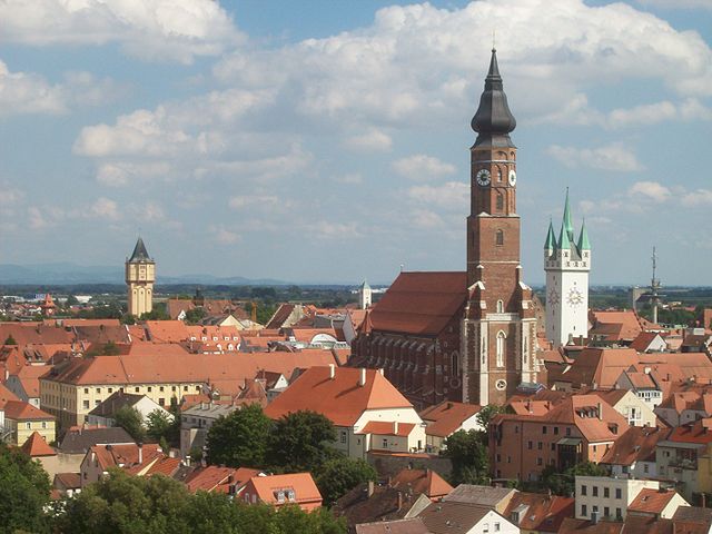
Деггендорф
- район в Баварии
Hiking in Деггендорф
Deggendorf, located in Bavaria, Germany, is a fantastic region for hiking enthusiasts. Nestled at the edge of the Bavarian Forest National Park and alongside the Danube River, it boasts a variety of landscapes and trails suitable for all skill levels....
- Страна:
- Столица: Деггендорф
- Код автомобильного номера: DEG
- Координаты: 48° 49' 48" N, 13° 0' 0" E
- GPS треки (wikiloc): [Ссылка]
- Высота над уровнем моря: 309 м m
- Площадь: 861.00 кв.км
- Население: 115005
- Веб сайт: [Ссылка]
Фрайунг-Графенау
Hiking in Фрайунг-Графенау
Freyung-Grafenau is a beautiful district located in Bavaria, Germany, known for its stunning landscapes, dense forests, and rugged terrain, making it a great destination for hiking enthusiasts. Here are some highlights and trails to consider when hiking in the area:...
- Страна:
- Столица: Фрейунг
- Код автомобильного номера: WOS; GRA; FRG
- Координаты: 48° 49' 48" N, 13° 30' 0" E
- GPS треки (wikiloc): [Ссылка]
- Высота над уровнем моря: 693 м m
- Площадь: 984.00 кв.км
- Население: 75564
- Веб сайт: [Ссылка]