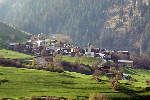
Lumnezia/Lugnez (Kreis Lumnezia/Lugnez)
 Hiking in Lumnezia/Lugnez
Kreis Lumnezia, located in the canton of Graubünden in Switzerland, is a remarkable area for hiking, known for its stunning alpine scenery, diverse landscapes, and charming villages. Here are some key points about hiking in this region:
Scenic Beauty
- Dramatic Landscapes: The area features a mix of lush valleys, rugged mountains, and serene lakes, making it a paradise for nature lovers.
- Flora and Fauna: Hikers can encounter diverse plant life and wildlife, with opportunities to see unique alpine species.
Hiking Trails
- Variety of Trails: The region offers a range of hiking trails suitable for all levels, from easy walks through picturesque villages to challenging high-altitude hikes.
- Marked Paths: Most trails are well-marked and maintained, providing clear signage to help navigate the routes.
- Themed Hikes: Some trails focus on specific themes, such as cultural heritage, local history, or natural features.
Popular Hiking Routes
- The Lumnezia Valley: Explore the various paths along the valley, which offer breathtaking views of the surrounding mountains and traditional Swiss architecture.
- Mundaun Mountain: A popular hiking destination with panoramic views of the region and trails that cater to various skill levels.
- Hiking to Swiss Alpine Lakes: Several hikes can lead you to beautiful alpine lakes where you can relax and enjoy a picnic amidst stunning scenery.
Best Times to Hike
- Summer Months: The best time for hiking is typically from late spring through early autumn (May to October), when the trails are clear of snow and the weather is mild.
- Autumn: Early autumn offers beautiful fall foliage, making it a particularly scenic time for hikes.
Safety and Preparation
- Weather Awareness: Always check the weather before heading out, as alpine conditions can change rapidly.
- Proper Gear: Good hiking boots, appropriate clothing, and sufficient water and snacks are essential.
- Local Regulations: Be aware of local guidelines and regulations, particularly regarding wildlife and protected areas.
Accessibility
- Transport Links: The area is accessible by public transport and car, with various starting points for hikes within easy reach.
Cultural Aspects
- Local Villages: Many hikes allow you to pass through charming villages, where you can experience local culture, cuisine, and hospitality.
If you are planning a hiking trip to Kreis Lumnezia, be sure to take your time to enjoy the breathtaking views, local culture, and the rich natural environment. Always remember to follow Leave No Trace principles to help preserve the beauty of this wonderful area. Happy hiking!
- Страна:

- Хранилище Wikidata: Wikidata: Q680915
- Катеория в википедии: [Ссылка]
- идентификатор HDS: [8072]
Включает регионы:


Lumnezia
Hiking in Lumnezia
Lumnezia, located in the scenic canton of Graubünden in Switzerland, is a fantastic destination for hiking enthusiasts. Known for its breathtaking landscapes, lush meadows, and majestic mountains, Lumnezia offers a variety of hiking trails suitable for all skill levels. Here’s a closer look at what you can expect when hiking in this beautiful region:...
- Страна:
- Почтовый код: 7144
- Телефонный код: 081
- Код автомобильного номера: GR
- Координаты: 46° 43' 0" N, 9° 11' 0" E


- GPS треки (wikiloc): [Ссылка]
- Высота над уровнем моря: 1244 м m
- Площадь: 165.48 кв.км
- Население: 2047
- Веб сайт: [Ссылка]


Вальс
- община в кантоне Граубюнден, Швейцария
Hiking in Вальс
Vals, Switzerland, is a stunning hiking destination known for its picturesque landscapes, pristine nature, and serene environment. Nestled in the Swiss Alps, Vals offers a range of hiking trails suitable for all levels of hikers, from beginners to experienced trekkers. Here are some highlights of hiking in Vals:...
- Страна:
- Почтовый код: 7132
- Телефонный код: 081
- Код автомобильного номера: GR
- Координаты: 46° 36' 59" N, 9° 11' 0" E
- GPS треки (wikiloc): [Ссылка]
- Высота над уровнем моря: 1252 м m
- Площадь: 152.73 кв.км
- Население: 1050
- Веб сайт: [Ссылка]


Санкт-Мартин
- община в Швейцарии, Граубюнден
Hiking in Санкт-Мартин
Hiking in St. Martin, Graubünden, offers a beautiful experience within the Swiss Alps, characterized by stunning landscapes, diverse trails, and a rich cultural heritage. Here are some key points to consider when planning your hiking adventure in this picturesque region:...
- Страна:
- Почтовый код: 7116
- Телефонный код: 081
- Код автомобильного номера: GR
- Координаты: 46° 39' 59" N, 9° 9' 59" E
- GPS треки (wikiloc): [Ссылка]
- Высота над уровнем моря: 1003 м m
- Площадь: 22.83 кв.км
- Веб сайт: [Ссылка]

Дувин
Hiking in Дувин
Duvin is not a widely recognized hiking destination, so it may not have extensive information available. However, if you're referring to a specific region or area known as Duvin, I would recommend confirming its geographical location or context (such as a nearby city or country), as it could be a lesser-known local spot....
- Страна:
- Почтовый код: 7112
- Телефонный код: 081
- Код автомобильного номера: GR
- Координаты: 46° 42' 59" N, 9° 13' 0" E
- GPS треки (wikiloc): [Ссылка]
- Высота над уровнем моря: 1180 м m
- Площадь: 17.93 кв.км
- Веб сайт: [Ссылка]