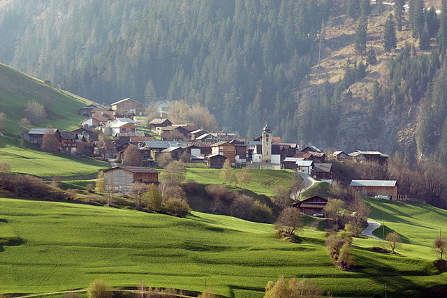
Санкт-Мартин (St. Martin, St. Martin)

- община в Швейцарии, Граубюнден
 Hiking in Санкт-Мартин
Hiking in St. Martin, Graubünden, offers a beautiful experience within the Swiss Alps, characterized by stunning landscapes, diverse trails, and a rich cultural heritage. Here are some key points to consider when planning your hiking adventure in this picturesque region:
Trails
-
Variety of Trails: The area features a range of hiking trails suitable for various skill levels, from easy walks to challenging mountainous routes. Most trails are well-marked and maintained, enhancing the overall experience.
-
Scenic Views: Many trails provide breathtaking views of the Alps, valleys, and local flora and fauna. You might encounter alpine meadows, crystal-clear streams, and impressive mountain peaks.
-
Popular Routes:
- Hiking to Alp Val: This route offers a manageable hike with beautiful views and is perfect for families.
- St. Martin to Panix Pass: A more demanding hike that rewards you with spectacular vistas and a sense of wilderness.
- Circular routes: There are several circular hiking options that allow you to explore the region fully without retracing your steps.
Seasonal Considerations
- Spring and Summer: These seasons are ideal for hiking, as trails are typically clear of snow, and the wildflowers bloom in vibrant colors.
- Autumn: The fall colors provide a stunning backdrop for hikes, though some higher altitude trails may be less accessible due to snow.
- Winter: While hiking can still be done in lower areas, snowshoeing and winter hiking might be more appropriate depending on the conditions.
Local Culture and Wildlife
- Cultural Attractions: While hiking, don’t miss out on local cultural sites, such as traditional villages, and historical landmarks.
- Wildlife: Keep an eye out for local wildlife, such as chamois and various bird species, especially in more remote areas.
Facilities
- Guided Tours: Consider joining a guided hiking tour to gain insights about the region's natural history and cultural significance.
- Accommodations: St. Martin offers various accommodation options, including hotels, guesthouses, and mountain huts for those who wish to hike multiple days.
Safety Tips
- Weather Awareness: Always check the weather forecast before heading out. Alpine weather can change rapidly.
- Gear: Wear appropriate hiking footwear and carry essential gear like a map, compass, first-aid kit, water, and snacks.
- Trail Etiquette: Follow local guidelines for hiking and respect nature; stick to marked paths to protect the environment.
Overall, hiking in St. Martin, Graubünden, presents an incredible opportunity to immerse yourself in the natural beauty of the Swiss Alps while enjoying the unique cultural experiences the region has to offer.
- Страна:

- Почтовый код: 7116
- Телефонный код: 081
- Код автомобильного номера: GR
- Координаты: 46° 39' 59" N, 9° 9' 59" E


- GPS треки (wikiloc): [Ссылка]
- Высота над уровнем моря: 1003 м m
- Площадь: 22.83 кв.км
- Веб сайт: http://stmartin-lugnez.ch
- Википедия русская: wiki(ru)
- Википедия английская: wiki(en)
- Википедия национальная: wiki(de)
- Хранилище Wikidata: Wikidata: Q64813
- Катеория в википедии: [Ссылка]
- код Freebase: [/m/026gnvc]
- код GeoNames: Альт: [2658815]
- идентификатор HDS: [1456]
- код швейцарского муниципалитета: [3598]
Граничит с регионами:


Вальс
- община в кантоне Граубюнден, Швейцария
Hiking in Вальс
Vals, Switzerland, is a stunning hiking destination known for its picturesque landscapes, pristine nature, and serene environment. Nestled in the Swiss Alps, Vals offers a range of hiking trails suitable for all levels of hikers, from beginners to experienced trekkers. Here are some highlights of hiking in Vals:...
- Страна:
- Почтовый код: 7132
- Телефонный код: 081
- Код автомобильного номера: GR
- Координаты: 46° 36' 59" N, 9° 11' 0" E
- GPS треки (wikiloc): [Ссылка]
- Высота над уровнем моря: 1252 м m
- Площадь: 152.73 кв.км
- Население: 1050
- Веб сайт: [Ссылка]

Дувин
Hiking in Дувин
Duvin is not a widely recognized hiking destination, so it may not have extensive information available. However, if you're referring to a specific region or area known as Duvin, I would recommend confirming its geographical location or context (such as a nearby city or country), as it could be a lesser-known local spot....
- Страна:
- Почтовый код: 7112
- Телефонный код: 081
- Код автомобильного номера: GR
- Координаты: 46° 42' 59" N, 9° 13' 0" E
- GPS треки (wikiloc): [Ссылка]
- Высота над уровнем моря: 1180 м m
- Площадь: 17.93 кв.км
- Веб сайт: [Ссылка]