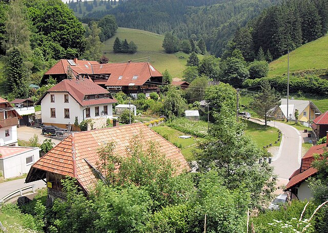
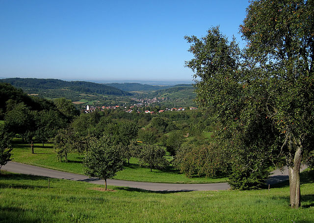
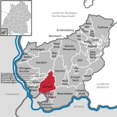
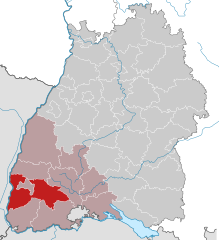
Лёррах (Lörrach, Landkreis Lörrach)

 Hiking in Лёррах
Lörrach is a district located in southern Germany, near the borders with Switzerland and France. It is surrounded by the scenic beauty of the Black Forest and offers a variety of hiking opportunities for outdoor enthusiasts. Here’s some information about hiking in the Lörrach area:
Trail Variety
-
Black Forest Trails: The region has numerous well-marked trails that lead through beautiful forests, picturesque villages, and breathtaking viewpoints. The Black Forest is known for its dense woods, rolling hills, and clear streams.
-
Scenic Routes: Hikes can take you to the summit of nearby hills, such as the Blauen or Hochblauen, where you can enjoy panoramic views of the Rhine Valley and, on clear days, the Swiss Alps.
-
Nature Reserves: Various nature reserves in the area provide opportunities for peaceful hikes amidst diverse flora and fauna. The Naturschutzgebiet Wiese and other protected areas are great for nature lovers.
Trail Difficulties
Trails in the Lörrach district range from easy walks suitable for families and beginners to more challenging hikes for experienced hikers. You’ll find everything from gentle slopes to steeper ascents, so you can choose hikes based on your fitness level and preferences.
Hiking Resources
- Maps and Guides: Local tourist information centers in Lörrach provide maps and guides for hiking trails in the area, which can be very helpful for planning your routes.
- Apps: Consider using hiking apps that feature GPS tracking and trail information, which can enhance your hiking experience.
Local Attractions
While hiking, you may also want to explore some local attractions, including:
- Burgruine Rötteln: A historical castle ruin that offers great views and a glimpse into the region's history.
- Lörrach Town Center: Discover local shops and cafés, perfect for a post-hike snack or meal.
Best Seasons for Hiking
The best time for hiking in Lörrach is typically from late spring to early autumn when the weather is more stable and the landscapes are vibrant. However, you can also enjoy winter hikes if you’re equipped for colder conditions and potential snow.
Important Tips
- Stay hydrated and pack snacks, as some trails may not have easy access to facilities.
- Always dress in layers and wear proper hiking footwear, especially when venturing into more rugged areas.
- Be mindful of local wildlife and plants, and always stick to marked trails to preserve the natural environment.
In summary, Lörrach offers diverse hiking options suitable for all abilities, set against a backdrop of stunning landscapes. Whether you're looking for a leisurely stroll or a challenging trek, you're likely to find a trail that meets your needs in this beautiful region.
- Страна:

- Столица: Лёррах
- Код автомобильного номера: LÖ
- Координаты: 47° 39' 0" N, 7° 42' 0" E


- GPS треки (wikiloc): [Ссылка]
- Высота над уровнем моря: 621 м m
- Площадь: 806.81 кв.км
- Население: 220606
- Веб сайт: http://www.loerrach-landkreis.de/
- Википедия русская: wiki(ru)
- Википедия английская: wiki(en)
- Википедия национальная: wiki(de)
- Хранилище Wikidata: Wikidata: Q8198
- Катеория в википедии: [Ссылка]
- код Freebase: [/m/01g32w]
- код GeoNames: Альт: [3214108]
- код VIAF: Альт: [158303206]
- ID отношения в OpenStreetMap: [62587]
- код GND: Альт: [4036148-2]
- идентификатор местоположения ArchINFORM: [2499]
- код LCNAF: Альт: [n82144486]
- код TGN: [7075014]
- код ISNI: Альт: [0000 0004 4910 4564]
- код NUTS: [DE139]
- код района Германии: 08336
Включает регионы:


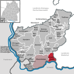
Райнфельден
Hiking in Райнфельден
Rheinfelden (Baden) is a charming town located on the banks of the Rhine River in Germany's Baden-Württemberg region, close to the Swiss border. It offers a variety of outdoor activities, including hiking, which allows visitors to enjoy both picturesque landscapes and cultural sites....
- Страна:
- Почтовый код: 79618
- Телефонный код: 07623
- Координаты: 47° 33' 40" N, 7° 47' 30" E
- GPS треки (wikiloc): [Ссылка]
- Высота над уровнем моря: 273 м m
- Площадь: 62.84 кв.км
- Население: 32441
- Веб сайт: [Ссылка]


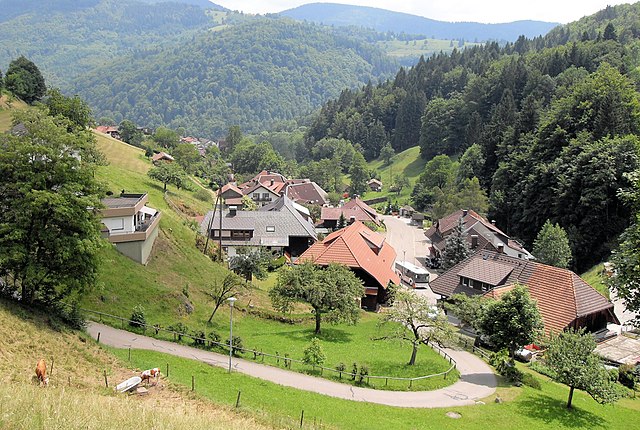
Виден
Hiking in Виден
Wieden, located in the Lörrach district of Germany, offers a variety of hiking opportunities that cater to different skill levels and preferences. Nestled in the foothills of the Black Forest, Wieden is characterized by its beautiful landscapes, dense forests, and stunning views of the surrounding area, including the nearby Swiss and French borders....
- Страна:
- Почтовый код: 79695
- Телефонный код: 07673
- Координаты: 47° 50' 27" N, 7° 52' 54" E
- GPS треки (wikiloc): [Ссылка]
- Высота над уровнем моря: 828 м m
- Площадь: 12.25 кв.км
- Население: 593
- Веб сайт: [Ссылка]


Фишинген
Hiking in Фишинген
Fischingen, located in Baden-Württemberg, Germany, is a charming village nestled in the picturesque landscape of the Swabian Jura. The area is known for its stunning natural beauty, making it an excellent destination for hiking enthusiasts....
- Страна:
- Почтовый код: 79592
- Телефонный код: 07628
- Код автомобильного номера: LÖ
- Координаты: 47° 38' 59" N, 7° 35' 59" E
- GPS треки (wikiloc): [Ссылка]
- Высота над уровнем моря: 739 м m
- Площадь: 1.89 кв.км
- Население: 781
- Веб сайт: [Ссылка]


Целль
- город в Германии, Баден-Вюртемберг
Hiking in Целль
Zell im Wiesental is a charming town located in the heart of the Black Forest region in Germany. It offers numerous opportunities for hiking enthusiasts, with picturesque landscapes, charming settlements, and diverse trails suitable for different skill levels. Here are some highlights for hiking in and around Zell im Wiesental:...
- Страна:
- Почтовый код: 79669
- Телефонный код: 07625
- Координаты: 47° 42' 25" N, 7° 51' 5" E
- GPS треки (wikiloc): [Ссылка]
- Высота над уровнем моря: 443 м m
- Площадь: 36.13 кв.км
- Население: 6142
- Веб сайт: [Ссылка]


Бад-Беллинген
Hiking in Бад-Беллинген
Bad Bellingen, located in the picturesque region of Baden-Württemberg, Germany, near the borders of Switzerland and France, is a great destination for hiking enthusiasts. The area is known for its beautiful landscapes, diverse flora and fauna, and scenic views, especially from the nearby south-facing slopes of the Black Forest and the Rhine Valley....
- Страна:
- Почтовый код: 79411–79415
- Телефонный код: 07635
- Координаты: 47° 43' 54" N, 7° 33' 25" E
- GPS треки (wikiloc): [Ссылка]
- Высота над уровнем моря: 257 м m
- Площадь: 16.93 кв.км
- Население: 4084
- Веб сайт: [Ссылка]


Тунау
Hiking in Тунау
Tunau, also known as the Tunau mountain, is located in the region of Hesse in Germany. It offers a wealth of opportunities for hiking enthusiasts, with its picturesque landscapes, diverse flora and fauna, and well-marked trails....
- Страна:
- Почтовый код: 79677
- Телефонный код: 07673
- Координаты: 47° 47' 9" N, 7° 55' 26" E
- GPS треки (wikiloc): [Ссылка]
- Высота над уровнем моря: 734 м m
- Площадь: 4.05 кв.км
- Население: 181
- Веб сайт: [Ссылка]


Фрёнд
Hiking in Фрёнд
Fröhnd is a charming village located in the Black Forest region of Germany, known for its picturesque landscapes, lush greenery, and a network of hiking trails that cater to various skill levels. Here’s what you need to know about hiking in Fröhnd:...
- Страна:
- Почтовый код: 79677
- Телефонный код: 07673
- Код автомобильного номера: LÖ
- Координаты: 47° 45' 30" N, 7° 53' 3" E
- GPS треки (wikiloc): [Ссылка]
- Высота над уровнем моря: 554 м m
- Площадь: 16.2 кв.км
- Население: 464
- Веб сайт: [Ссылка]

Бёллен
Hiking in Бёллен
Böllen is a picturesque small village located in the heart of the Black Forest region in Germany. It offers a plethora of hiking opportunities for enthusiasts of all skill levels. Here are some key highlights about hiking in and around Böllen:...
- Страна:
- Почтовый код: 79677
- Телефонный код: 07673
- Координаты: 47° 48' 7" N, 7° 50' 27" E
- GPS треки (wikiloc): [Ссылка]
- Высота над уровнем моря: 760 м m
- Площадь: 5.66 кв.км
- Население: 94
- Веб сайт: [Ссылка]

Аймельдинген
Hiking in Аймельдинген
Eimeldingen is a small village located in the German state of Baden-Württemberg, near the borders with France and Switzerland. While it may not be as well-known as some larger hiking destinations, Eimeldingen and its surrounding region offer a variety of scenic trails and nature experiences....
- Страна:
- Почтовый код: 79591
- Телефонный код: 07621
- Координаты: 47° 38' 0" N, 7° 36' 0" E
- GPS треки (wikiloc): [Ссылка]
- Высота над уровнем моря: 264 м m
- Площадь: 3.55 кв.км
- Население: 2447
- Веб сайт: [Ссылка]


Эфринген-Кирхен
Hiking in Эфринген-Кирхен
Efringen-Kirchen, located in the state of Baden-Württemberg, Germany, is nestled in a picturesque area near the borders of Switzerland and France. The region offers various hiking opportunities that allow you to explore its beautiful landscapes, vineyards, and forests....
- Страна:
- Почтовый код: 79588
- Телефонный код: 07628
- Координаты: 47° 39' 20" N, 7° 33' 57" E
- GPS треки (wikiloc): [Ссылка]
- Высота над уровнем моря: 258 м m
- Площадь: 43.74 кв.км
- Население: 8431
- Веб сайт: [Ссылка]


Витлинген
Hiking in Витлинген
Wittlingen is a charming village located in the southern part of Germany, near the border with Switzerland. It offers several opportunities for hiking and exploring the picturesque landscapes of the Black Forest region. Here are some highlights for hiking in and around Wittlingen:...
- Страна:
- Почтовый код: 79599
- Телефонный код: 07621
- Координаты: 47° 39' 19" N, 7° 39' 4" E
- GPS треки (wikiloc): [Ссылка]
- Высота над уровнем моря: 304 м m
- Площадь: 4.5 кв.км
- Население: 965


Инцлинген
Hiking in Инцлинген
Inzlingen is a picturesque village located in the southern part of Germany, near the border with Switzerland. Its proximity to both the Black Forest and the Rhine River offers numerous opportunities for hiking enthusiasts. Here are some key points to consider if you're planning to hike in and around Inzlingen:...
- Страна:
- Почтовый код: 79594
- Телефонный код: 07621
- Координаты: 47° 35' 19" N, 7° 41' 27" E
- GPS треки (wikiloc): [Ссылка]
- Высота над уровнем моря: 372 м m
- Площадь: 9.48 кв.км
- Население: 2434
- Веб сайт: [Ссылка]


Кандерн
Hiking in Кандерн
Kandern, located in the southwestern part of Germany in the state of Baden-Württemberg, is a picturesque town nestled in the scenic Black Forest region. Hiking in and around Kandern offers a beautiful experience for both beginners and seasoned hikers, with a variety of trails that showcase the stunning landscape....
- Страна:
- Почтовый код: 79400
- Телефонный код: 07626
- Координаты: 47° 42' 52" N, 7° 39' 39" E
- GPS треки (wikiloc): [Ссылка]
- Высота над уровнем моря: 352 м m
- Площадь: 62.27 кв.км
- Население: 8163
- Веб сайт: [Ссылка]


Тодтнау
Hiking in Тодтнау
Todtnau, located in the Black Forest region of Germany, is an excellent hiking destination known for its stunning natural beauty, diverse landscapes, and rich cultural heritage. Here’s what you can expect when hiking in this picturesque area:...
- Страна:
- Почтовый код: 79674
- Телефонный код: 07671
- Координаты: 47° 49' 46" N, 7° 56' 38" E
- GPS треки (wikiloc): [Ссылка]
- Высота над уровнем моря: 659 м m
- Площадь: 69.59 кв.км
- Население: 4904
- Веб сайт: [Ссылка]


Шёнау
- город в Германии, Баден-Вюртемберг
Hiking in Шёнау
Schönau im Schwarzwald is a picturesque village located in the heart of the Black Forest (Schwarzwald) region of Germany. It is renowned for its stunning natural landscapes, dense forests, and serene lakes, making it a fantastic destination for hiking enthusiasts. Here are some aspects to consider when hiking in Schönau im Schwarzwald:...
- Страна:
- Почтовый код: 79677
- Телефонный код: 07673
- Координаты: 47° 47' 12" N, 7° 53' 39" E
- GPS треки (wikiloc): [Ссылка]
- Высота над уровнем моря: 540 м m
- Площадь: 14.7 кв.км
- Население: 2390
- Веб сайт: [Ссылка]


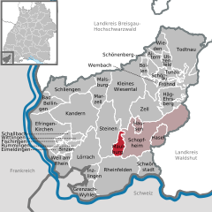
Шопфхайм
Hiking in Шопфхайм
Schopfheim is located in the southwestern part of Germany, in the state of Baden-Württemberg. It's surrounded by picturesque landscapes, making it an excellent destination for hiking enthusiasts. The region is characterized by its diverse terrain, including rolling hills, dense forests, and panoramic views of the Black Forest....
- Страна:
- Почтовый код: 79641–79650
- Телефонный код: 07622
- Координаты: 47° 38' 58" N, 7° 49' 29" E
- GPS треки (wikiloc): [Ссылка]
- Высота над уровнем моря: 373 м m
- Площадь: 67.98 кв.км
- Население: 19124
- Веб сайт: [Ссылка]

Айтерн
Hiking in Айтерн
Aitern is a charming village located in the southern part of Germany, nestled in the Black Forest region. It offers a range of hiking opportunities suitable for various skill levels, making it a great destination for outdoor enthusiasts....
- Страна:
- Почтовый код: 79677
- Телефонный код: 07673
- Координаты: 47° 48' 0" N, 7° 54' 0" E
- GPS треки (wikiloc): [Ссылка]
- Высота над уровнем моря: 610 м m
- Площадь: 9.21 кв.км
- Население: 563
- Веб сайт: [Ссылка]

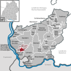
Вайль-на-Рейне
Hiking in Вайль-на-Рейне
Weil am Rhein, located in the border region where Germany, France, and Switzerland meet, offers a variety of hiking opportunities that showcase beautiful landscapes, cultural sights, and diverse ecosystems. Here are some insights about hiking in this area:...
- Страна:
- Почтовый код: 79546–79576
- Телефонный код: 07621
- Координаты: 47° 35' 41" N, 7° 36' 39" E
- GPS треки (wikiloc): [Ссылка]
- Высота над уровнем моря: 281 м m
- Площадь: 19.46 кв.км
- Население: 29683
- Веб сайт: [Ссылка]

Маульбург
Hiking in Маульбург
Maulburg is a charming village located in the Baden-Württemberg region of Germany, close to the borders with France and Switzerland. While it may not be as well-known as other hiking destinations, it offers lovely rural landscapes and a variety of trails that are perfect for hikers of all levels....
- Страна:
- Почтовый код: 79689
- Телефонный код: 07622
- Координаты: 47° 38' 47" N, 7° 46' 56" E
- GPS треки (wikiloc): [Ссылка]
- Высота над уровнем моря: 350 м m
- Площадь: 9.73 кв.км
- Население: 4192
- Веб сайт: [Ссылка]


Вембах
Hiking in Вембах
Wembach is a picturesque area that offers a variety of hiking opportunities, with trails suitable for different skill levels. It’s important to prepare properly, so here are some key points to consider when hiking in Wembach:...
- Страна:
- Почтовый код: 79677
- Телефонный код: 07673
- Координаты: 47° 46' 23" N, 7° 53' 5" E
- GPS треки (wikiloc): [Ссылка]
- Высота над уровнем моря: 528 м m
- Площадь: 1.8 кв.км
- Население: 342
- Веб сайт: [Ссылка]

Хазель
Hiking in Хазель
Hasel, Germany, is a charming village located in the scenic region of the Black Forest (Schwarzwald) in Baden-Württemberg. It offers a variety of hiking opportunities for enthusiasts of all levels, from easy walks to more challenging trails. Here's what you should know about hiking in Hasel:...
- Страна:
- Почтовый код: 79686
- Телефонный код: 07762
- Координаты: 47° 39' 16" N, 7° 53' 52" E
- GPS треки (wikiloc): [Ссылка]
- Высота над уровнем моря: 425 м m
- Площадь: 11.65 кв.км
- Население: 1131
- Веб сайт: [Ссылка]

Швёрштадт
Hiking in Швёрштадт
Schwörstadt is a small village located in the Lörrach district of Baden-Württemberg, Germany. Nestled near the borders of Switzerland and France, it offers a unique opportunity for outdoor enthusiasts, particularly hikers, to explore the scenic beauty of the region....
- Страна:
- Почтовый код: 79739
- Телефонный код: 07762
- Координаты: 47° 35' 35" N, 7° 52' 42" E
- GPS треки (wikiloc): [Ссылка]
- Высота над уровнем моря: 298 м m
- Площадь: 20.06 кв.км
- Население: 2406
- Веб сайт: [Ссылка]


Гренцах-Вилен
Hiking in Гренцах-Вилен
Grenzach-Wyhlen is a charming town located in the southern part of Germany, near the borders of Switzerland and France. It's positioned along the banks of the Rhine River, providing a picturesque backdrop for hiking enthusiasts. Here are some key aspects to consider when hiking in this region:...
- Страна:
- Почтовый код: 79639
- Телефонный код: 07624
- Код автомобильного номера: LÖ
- Координаты: 47° 33' 0" N, 7° 41' 0" E
- GPS треки (wikiloc): [Ссылка]
- Высота над уровнем моря: 269 м m
- Площадь: 17.32 кв.км
- Население: 14073
- Веб сайт: [Ссылка]


Хаузен
- муниципалитет в Германии, Баден-Вюртемберг
Hiking in Хаузен
Hausen im Wiesental is a charming village located in the Black Forest region of Germany, known for its picturesque landscapes and numerous hiking opportunities. Here are some highlights and tips for hiking in this area:...
- Страна:
- Почтовый код: 79688
- Телефонный код: 07622
- Координаты: 47° 40' 53" N, 7° 50' 26" E
- GPS треки (wikiloc): [Ссылка]
- Высота над уровнем моря: 404 м m
- Площадь: 5.14 кв.км
- Население: 2362
- Веб сайт: [Ссылка]

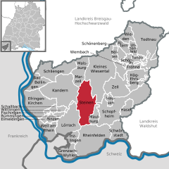
Штайнен
Hiking in Штайнен
Steinen, located in the scenic region of Baden-Württemberg, Germany, offers beautiful hiking opportunities with a variety of trails suitable for different skill levels. The area is known for its lush landscapes, rolling hills, and picturesque views of the surrounding countryside....
- Страна:
- Почтовый код: 79585
- Телефонный код: 07627
- Координаты: 47° 38' 43" N, 7° 44' 25" E
- GPS треки (wikiloc): [Ссылка]
- Высота над уровнем моря: 338 м m
- Площадь: 46.86 кв.км
- Население: 9790
- Веб сайт: [Ссылка]


Шальбах
Hiking in Шальбах
Schallbach is a charming area located in the Alsace region of France, offering a variety of hiking opportunities amidst beautiful landscapes. While it may not be as well-known as some larger hiking destinations, its picturesque scenery and local charm make it worth exploring. Here are some key points to consider when hiking in and around Schallbach:...
- Страна:
- Почтовый код: 79597
- Телефонный код: 07621
- Координаты: 47° 39' 16" N, 7° 37' 36" E
- GPS треки (wikiloc): [Ссылка]
- Высота над уровнем моря: 301 м m
- Площадь: 3.95 кв.км
- Население: 756
- Веб сайт: [Ссылка]


Kleines Wiesental
Hiking in Kleines Wiesental
Kleines Wiesental is a picturesque valley located in the southern Black Forest region of Germany, known for its natural beauty and outdoor activities, including hiking. Here are some key points about hiking in the Kleines Wiesental area:...
- Страна:
- Почтовый код: 79692
- Телефонный код: 07673; 07629; 07622
- Координаты: 47° 43' 11" N, 7° 47' 40" E
- GPS треки (wikiloc): [Ссылка]
- Высота над уровнем моря: 584 м m
- Площадь: 77.84 кв.км
- Население: 2859
- Веб сайт: [Ссылка]


Рюмминген
Hiking in Рюмминген
Rümmingen, located in the southwestern part of Germany near the border with France and Switzerland, is an excellent spot for hiking. The region is characterized by its picturesque landscapes, lush forests, and rolling hills, making it ideal for outdoor enthusiasts....
- Страна:
- Почтовый код: 79595
- Телефонный код: 07621
- Координаты: 47° 39' 0" N, 7° 39' 0" E
- GPS треки (wikiloc): [Ссылка]
- Высота над уровнем моря: 291 м m
- Площадь: 4.46 кв.км
- Население: 1719
- Веб сайт: [Ссылка]


Утценфельд
Hiking in Утценфельд
Utzenfeld is a charming village located in the scenic region of the Black Forest (Schwarzwald) in Germany. This area is known for its lush landscapes, diverse flora and fauna, and numerous hiking trails that cater to various skill levels. Here are some highlights when hiking in and around Utzenfeld:...
- Страна:
- Почтовый код: 79694
- Телефонный код: 07673
- Координаты: 47° 48' 0" N, 7° 55' 0" E
- GPS треки (wikiloc): [Ссылка]
- Высота над уровнем моря: 561 м m
- Площадь: 7.4 кв.км
- Население: 615
- Веб сайт: [Ссылка]


Мальсбург-Марцелль
Hiking in Мальсбург-Марцелль
Malsburg-Marzell is a picturesque village located in the southern part of Germany, near the border with Switzerland, nestled within the lush landscapes of the Black Forest region. This area offers a variety of hiking opportunities that cater to different skill levels, from leisurely walks to more challenging trails....
- Страна:
- Почтовый код: 79429
- Телефонный код: 07626
- Координаты: 47° 46' 15" N, 7° 43' 32" E
- GPS треки (wikiloc): [Ссылка]
- Высота над уровнем моря: 495 м m
- Площадь: 24.9 кв.км
- Население: 1446
- Веб сайт: [Ссылка]

Бинцен
Hiking in Бинцен
Binzen is a charming village located in the state of Baden-Württemberg, Germany, near the borders with Switzerland and France. Its picturesque landscapes and proximity to the Rhine River make it an excellent spot for hiking enthusiasts. Here are some things to consider when hiking in Binzen:...
- Страна:
- Почтовый код: 79589
- Телефонный код: 07621
- Координаты: 47° 38' 0" N, 7° 37' 0" E
- GPS треки (wikiloc): [Ссылка]
- Высота над уровнем моря: 282 м m
- Площадь: 5.81 кв.км
- Население: 2973
- Веб сайт: [Ссылка]

Шлинген
Hiking in Шлинген
Schliengen is a picturesque town located in the southern part of Germany, near the border with Switzerland. It’s nestled in the scenic region of Baden-Württemberg, which is known for its beautiful landscapes, including rolling hills, vineyards, and the nearby Black Forest....
- Страна:
- Почтовый код: 79418
- Телефонный код: 07635
- Координаты: 47° 45' 25" N, 7° 34' 35" E
- GPS треки (wikiloc): [Ссылка]
- Высота над уровнем моря: 243 м m
- Площадь: 37.46 кв.км
- Население: 5412
- Веб сайт: [Ссылка]


Хег-Эрсберг
Hiking in Хег-Эрсберг
Häg-Ehrsberg, located in the scenic Black Forest region of Germany, offers a variety of hiking opportunities for both beginners and experienced hikers. The area is known for its beautiful landscapes, lush forests, rolling hills, and charming villages....
- Страна:
- Почтовый код: 79685
- Телефонный код: 07625
- Код автомобильного номера: LÖ
- Координаты: 47° 44' 2" N, 7° 55' 0" E
- GPS треки (wikiloc): [Ссылка]
- Высота над уровнем моря: 681 м m
- Площадь: 25.04 кв.км
- Население: 869
- Веб сайт: [Ссылка]
Шёненберг
Hiking in Шёненберг
Schönenberg, located in the beautiful state of Baden-Württemberg, Germany, is a delightful destination for hiking enthusiasts. The region is characterized by rolling hills, lush forests, and picturesque landscapes, offering a variety of trails suitable for all skill levels....
- Страна:
- Почтовый код: 79677
- Телефонный код: 07673
- Координаты: 47° 47' 34" N, 7° 52' 57" E
- GPS треки (wikiloc): [Ссылка]
- Высота над уровнем моря: 680 м m
- Площадь: 7.43 кв.км
- Население: 350
- Веб сайт: [Ссылка]

Лёррах
Hiking in Лёррах
Lörrach, located in the southwestern part of Germany near the border with Switzerland, offers a variety of hiking opportunities that showcase the region's beautiful landscapes and natural features. Here are some highlights and tips for hiking in and around Lörrach:...
- Страна:
- Почтовый код: 79539–79541
- Телефонный код: 07621
- Координаты: 47° 36' 56" N, 7° 39' 41" E
- GPS треки (wikiloc): [Ссылка]
- Высота над уровнем моря: 294 м m
- Площадь: 39.42 кв.км
- Население: 48601
- Веб сайт: [Ссылка]
Граничит с регионами:

Брайсгау-Верхний Шварцвальд
Hiking in Брайсгау-Верхний Шварцвальд
Breisgau-Hochschwarzwald is a spectacular region in southwestern Germany, known for its diverse landscapes, lush forests, and scenic trails. It's located in the state of Baden-Württemberg and offers a myriad of hiking opportunities suitable for all skill levels. Here are some highlights about hiking in the area:...
- Страна:
- Столица: Фрайбург-им-Брайсгау
- Код автомобильного номера: FR
- Координаты: 47° 57' 0" N, 7° 51' 0" E
- GPS треки (wikiloc): [Ссылка]
- Высота над уровнем моря: 394 м m
- Площадь: 1378.30 кв.км
- Население: 247711
- Веб сайт: [Ссылка]