Ла-Шапель-дю-Мон-дю-Ша (La Chapelle-du-Mont-du-Chat, La Chapelle-du-Mont-du-Chat)

- коммуна во Франции
 Hiking in Ла-Шапель-дю-Мон-дю-Ша
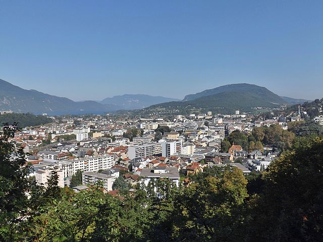
La Chapelle-du-Mont-du-Chat is a picturesque village located in the Savoie region of the French Alps. It is nestled at the foot of Mont du Chat, which offers stunning views and a variety of outdoor activities, including hiking. Here are some highlights and tips for hiking in this area:
Hiking Trails
-
Mont du Chat Summit Trail: This trail takes you to the summit of Mont du Chat. It's a moderate to challenging hike with rewarding views of Lake Bourget and the surrounding mountains. The trail can be steep in sections, so be prepared for a workout.
-
GR de Pays Tour des Bauges: This long-distance hiking trail circles the Bauges Massif and passes near La Chapelle-du-Mont-du-Chat. You can explore segments of this trail for a variety of landscapes including forests, pastures, and mountain viewpoints.
-
Lake Bourget Trails: While slightly further afield, the area around Lake Bourget features several beautiful walking paths that are less strenuous. These can be great for more leisurely hikes with opportunities to enjoy the lake views.
Tips for Hiking
-
Trail Conditions: Before heading out, check the trail conditions, especially after heavy rains or snowfall, as some paths may become slippery or inaccessible.
-
Pack Appropriately: Bring plenty of water, snacks, and appropriate clothing for changing weather conditions. Sturdy hiking boots are a must for rocky or steep trails.
-
Navigation: Make use of local maps or GPS devices, as some trails may not be well-marked. Additionally, consider downloading offline maps in case you lose signal.
-
Seasonal Considerations: Late spring through early autumn usually provides the best hiking conditions, but always check local weather conditions before setting out.
-
Respect the Environment: Stay on marked trails to protect the local flora and fauna, and remember to carry out any trash you bring with you.
Local Attractions
After a hike, consider exploring the local culture and cuisine. La Chapelle-du-Mont-du-Chat is close to traditional Savoyard villages and regions famous for cheese and other local delicacies.
Conclusion
Hiking in La Chapelle-du-Mont-du-Chat offers a blend of beautiful natural scenery, diverse trails, and a chance to experience the rich culture of the Savoie region. Whether you're seeking a challenging climb or a relaxing walk, you'll find plenty of options to enjoy the great outdoors.
- Страна:

- Почтовый код: 73370
- Координаты: 45° 42' 19" N, 5° 51' 15" E


- GPS треки (wikiloc): [Ссылка]
- Площадь: 7.08 кв.км
- Население: 252
- Википедия русская: wiki(ru)
- Википедия английская: wiki(en)
- Википедия национальная: wiki(fr)
- Хранилище Wikidata: Wikidata: Q736021
- Катеория в википедии: [Ссылка]
- код Freebase: [/m/03npfb5]
- код GeoNames: Альт: [6457066]
- номер SIREN: [217300763]
- код BNF: [15274010x]
- WOEID: [597457]
- код Pleiades: [167710]
- код муниципалитета INSEE: 73076
Граничит с регионами:


Ontex
- коммуна во Франции
Hiking in Ontex
It seems there might be a misunderstanding; "Ontex" primarily refers to a company specializing in healthcare products, including personal hygiene items, and isn't widely recognized as a hiking destination. If you're looking for hiking information, could you specify a location or region related to hiking? There are many beautiful hiking trails and areas in various countries that I can provide information on!...
- Страна:
- Почтовый код: 73310
- Координаты: 45° 45' 18" N, 5° 49' 17" E
- GPS треки (wikiloc): [Ссылка]
- Площадь: 4.62 кв.км
- Население: 95

Экс-ле-Бен
- коммуна во Франции
Hiking in Экс-ле-Бен
Aix-les-Bains, located in the Savoie region of France, is a beautiful town known for its thermal springs and stunning lakeside scenery. It’s an excellent base for hiking enthusiasts, offering a variety of trails set in the picturesque landscapes of the French Alps and around Lake Bourget, the largest natural lake in France....
- Страна:
- Почтовый код: 73100
- Координаты: 45° 41' 19" N, 5° 54' 54" E
- GPS треки (wikiloc): [Ссылка]
- Площадь: 12.62 кв.км
- Население: 29822
- Веб сайт: [Ссылка]


Saint-Jean-de-Chevelu
- коммуна во Франции
Hiking in Saint-Jean-de-Chevelu
Saint-Jean-de-Chevelu, located in the Savoie region of the French Alps, offers a wonderful opportunity for hikers looking to explore stunning natural landscapes. The area is known for its picturesque views, including the surrounding mountains, lush valleys, and tranquil lakes. Here are some highlights and tips for hiking in this beautiful region:...
- Страна:
- Почтовый код: 73170
- Координаты: 45° 41' 25" N, 5° 49' 9" E
- GPS треки (wikiloc): [Ссылка]
- Площадь: 12.72 кв.км
- Население: 804


Бурдо
- коммуна во Франции
Hiking in Бурдо
Bourdeau, located in the Savoie region of France, is a charming destination for hiking enthusiasts. Nestled near the shores of Lake Bourget, the area offers a combination of stunning lake views, picturesque landscapes, and the majestic backdrop of the French Alps....
- Страна:
- Почтовый код: 73370
- Координаты: 45° 41' 1" N, 5° 51' 21" E
- GPS треки (wikiloc): [Ссылка]
- Площадь: 4.83 кв.км
- Население: 545


Brison-Saint-Innocent
- коммуна во Франции
Hiking in Brison-Saint-Innocent
Brison-Saint-Innocent, located in the Auvergne-Rhône-Alpes region of France, near Lake Bourget, offers a beautiful setting for hiking enthusiasts. Here are some highlights and tips for hiking in this scenic area:...
- Страна:
- Почтовый код: 73100
- Координаты: 45° 43' 22" N, 5° 53' 26" E
- GPS треки (wikiloc): [Ссылка]
- Площадь: 8.75 кв.км
- Население: 2110
- Веб сайт: [Ссылка]


Billième
- коммуна во Франции
Hiking in Billième
Billième is a charming area in the French Alps, known for its stunning landscapes and variety of hiking opportunities. Here are some key points to consider when hiking in Billième:...
- Страна:
- Почтовый код: 73170
- Координаты: 45° 43' 9" N, 5° 48' 34" E
- GPS треки (wikiloc): [Ссылка]
- Площадь: 5.98 кв.км
- Население: 271


Сен-Пьер-де-Кюртий
- коммуна во Франции
Hiking in Сен-Пьер-де-Кюртий
Saint-Pierre-de-Curtille, located in the Savoie region of France near the shores of Lake Bourget, offers a beautiful setting for hiking enthusiasts. The area is characterized by stunning natural landscapes, including forests, hills, and views of the lake and surrounding mountains....
- Страна:
- Почтовый код: 73310
- Координаты: 45° 46' 32" N, 5° 48' 41" E
- GPS треки (wikiloc): [Ссылка]
- Площадь: 9.75 кв.км
- Население: 495
- Веб сайт: [Ссылка]