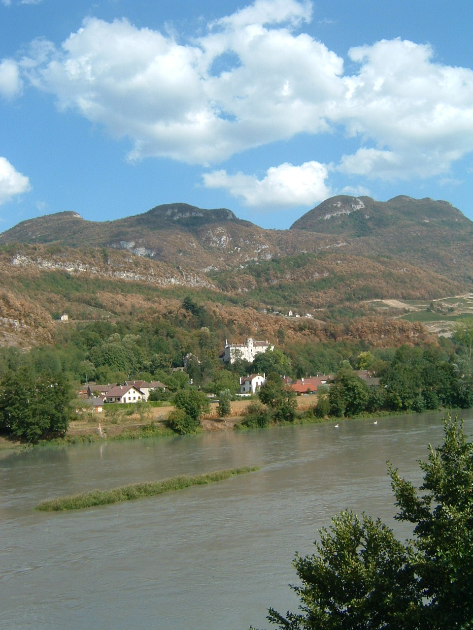
Сен-Пьер-де-Кюртий (Saint-Pierre-de-Curtille, Saint-Pierre-de-Curtille)

- коммуна во Франции
 Hiking in Сен-Пьер-де-Кюртий
Saint-Pierre-de-Curtille, located in the Savoie region of France near the shores of Lake Bourget, offers a beautiful setting for hiking enthusiasts. The area is characterized by stunning natural landscapes, including forests, hills, and views of the lake and surrounding mountains.
Hiking Trails
-
Lake Bourget Trails: Many trails run alongside Lake Bourget, providing picturesque views of the water and opportunities to explore the rich flora and fauna of the region. Don't miss the chance to follow the path that leads to the lake's different beaches.
-
Mont Revard: A short drive from Saint-Pierre-de-Curtille, Mont Revard offers various trails that lead to panoramic viewpoints of the Alps and the valley below. It's popular for both summer hiking and winter sports.
-
Regional Nature Reserve of Hauts de Chartreuse: While a bit further away, this area is accessible for day hikes and features more rugged terrain. Trails here can lead you through diverse ecosystems and offer encounters with local wildlife.
Tips for Hiking in Saint-Pierre-de-Curtille
- Trail Maps: Obtaining trail maps from local tourist offices will help you navigate the hiking routes.
- Weather Considerations: Always check the weather forecast before heading out, as conditions can change quickly in mountainous regions.
- Preparation: Wear sturdy hiking shoes and bring plenty of water, snacks, and a first-aid kit. It’s essential to stay hydrated, especially on warmer days.
- Respect Nature: Follow the Leave No Trace principles, ensuring that you pack out what you pack in to keep the trails clean and enjoyable for everyone.
Best Time to Hike
The best times for hiking in the Saint-Pierre-de-Curtille area are during the spring (April to June) and early autumn (September to October), when the weather is milder and the landscapes are vibrant with blooming flowers or autumn foliage.
Enjoy your hiking adventure in Saint-Pierre-de-Curtille, where breathtaking views await at every turn!
- Страна:

- Почтовый код: 73310
- Координаты: 45° 46' 32" N, 5° 48' 41" E


- GPS треки (wikiloc): [Ссылка]
- Площадь: 9.75 кв.км
- Население: 495
- Веб сайт: http://www.saintpierredecurtille.com
- Википедия английская: wiki(en)
- Википедия национальная: wiki(fr)
- Хранилище Wikidata: Wikidata: Q818983
- Катеория в википедии: [Ссылка]
- код Freebase: [/m/03npfrj]
- код GeoNames: Альт: [6442900]
- номер SIREN: [217302736]
- код BNF: [15274204j]
- код тезауруса PACTOLS: [pcrtOZkYTe1XbH]
- код муниципалитета INSEE: 73273
Граничит с регионами:


Ontex
- коммуна во Франции
Hiking in Ontex
It seems there might be a misunderstanding; "Ontex" primarily refers to a company specializing in healthcare products, including personal hygiene items, and isn't widely recognized as a hiking destination. If you're looking for hiking information, could you specify a location or region related to hiking? There are many beautiful hiking trails and areas in various countries that I can provide information on!...
- Страна:
- Почтовый код: 73310
- Координаты: 45° 45' 18" N, 5° 49' 17" E
- GPS треки (wikiloc): [Ссылка]
- Площадь: 4.62 кв.км
- Население: 95


Ла-Шапель-дю-Мон-дю-Ша
- коммуна во Франции
Hiking in Ла-Шапель-дю-Мон-дю-Ша
La Chapelle-du-Mont-du-Chat is a picturesque village located in the Savoie region of the French Alps. It is nestled at the foot of Mont du Chat, which offers stunning views and a variety of outdoor activities, including hiking. Here are some highlights and tips for hiking in this area:...
- Страна:
- Почтовый код: 73370
- Координаты: 45° 42' 19" N, 5° 51' 15" E
- GPS треки (wikiloc): [Ссылка]
- Площадь: 7.08 кв.км
- Население: 252


Brison-Saint-Innocent
- коммуна во Франции
Hiking in Brison-Saint-Innocent
Brison-Saint-Innocent, located in the Auvergne-Rhône-Alpes region of France, near Lake Bourget, offers a beautiful setting for hiking enthusiasts. Here are some highlights and tips for hiking in this scenic area:...
- Страна:
- Почтовый код: 73100
- Координаты: 45° 43' 22" N, 5° 53' 26" E
- GPS треки (wikiloc): [Ссылка]
- Площадь: 8.75 кв.км
- Население: 2110
- Веб сайт: [Ссылка]


Conjux
- коммуна во Франции
Hiking in Conjux
Conjux is a small but beautiful area located in the Savoie region of the French Alps, near Lake Bourget. While it's less known than some larger hiking destinations in the Alps, it offers a variety of trails and stunning natural scenery, making it a great destination for hiking enthusiasts....
- Страна:
- Почтовый код: 73310
- Координаты: 45° 47' 26" N, 5° 49' 17" E
- GPS треки (wikiloc): [Ссылка]
- Площадь: 1.7 кв.км
- Население: 202

Lucey
Hiking in Lucey
Lucey is a small commune located in the Savoie department in the Auvergne-Rhône-Alpes region of southeastern France. While it may not be as widely known for hiking as some of its neighboring areas, there are still ample opportunities for outdoor enthusiasts to explore the beautiful landscapes of the surrounding region....
- Страна:
- Почтовый код: 73170
- Координаты: 45° 45' 7" N, 5° 47' 14" E
- GPS треки (wikiloc): [Ссылка]
- Площадь: 6.14 кв.км
- Население: 317
Saint-Germain-la-Chambotte
- коммуна во Франции
Hiking in Saint-Germain-la-Chambotte
Saint-Germain-la-Chambotte is a picturesque village located in the Haute-Savoie region of southeastern France. Nestled in the French Alps, it offers breathtaking views and a variety of hiking opportunities suitable for different skill levels. Here’s what you can expect when hiking in this beautiful area:...
- Страна:
- Почтовый код: 73410
- Координаты: 45° 46' 41" N, 5° 53' 30" E
- GPS треки (wikiloc): [Ссылка]
- Площадь: 9.64 кв.км
- Население: 512


Chanaz
- коммуна во Франции
Hiking in Chanaz
Chanaz, often referred to as the "Venice of the Savoy," is a picturesque village located in the Auvergne-Rhône-Alpes region of France, near the Rhône River and surrounded by stunning natural landscapes. The area is known for its scenic routes and opportunities for hiking, making it an excellent destination for outdoor enthusiasts....
- Страна:
- Почтовый код: 73310
- Координаты: 45° 48' 31" N, 5° 47' 35" E
- GPS треки (wikiloc): [Ссылка]
- Площадь: 6.75 кв.км
- Население: 507
- Веб сайт: [Ссылка]