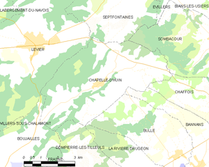
La Rivière-Drugeon (La Rivière-Drugeon)

- коммуна во Франции
 Hiking in La Rivière-Drugeon
La Rivière-Drugeon, located in the Doubs department of France, offers a beautiful setting for hiking enthusiasts. Nestled in the Jura Mountains, this area is characterized by stunning landscapes, lush forests, and scenic rivers. Here are some details about hiking in La Rivière-Drugeon:
Trails and Scenery
- Diverse Terrain: The hiking trails in La Rivière-Drugeon vary in difficulty, making it suitable for both beginners and experienced hikers. You'll find paths that traverse along rivers, through forests, and up hills or mountains, providing plenty of opportunities to enjoy nature.
- Natural Beauty: The area is known for its rich biodiversity, including various plant and animal species. Hikers can enjoy picturesque views of the surrounding landscapes, especially in the autumn when the foliage changes color.
- Lake and River Access: The proximity of the Drugeon River and several small lakes makes for lovely spots to take a break, have a picnic, or simply soak in the tranquil surroundings.
Popular Hiking Routes
- Les Rives du Drugeon Trail: A popular hiking trail that follows the banks of the Drugeon River. This route offers gentle terrain and is great for families.
- Montagne du Lomont: For those seeking a more challenging hike, routes leading up to the Montagne du Lomont offer stunning panoramic views.
Tips for Hiking in La Rivière-Drugeon
- Seasonal Considerations: Spring and fall are ideal times to hike in this area due to the mild weather and beautiful foliage. Summers can be warm, while winters may have snow, making some trails less accessible.
- Equipment: Wear suitable hiking boots and carry water, snacks, and a first-aid kit. A map or GPS device can be very helpful for navigation.
- Local Guidelines: Respect the natural environment and any local guidelines while hiking. Stay on marked paths to help preserve the area’s beauty.
Additional Activities
In addition to hiking, the region offers opportunities for birdwatching, cycling, and photography, making it a versatile destination for outdoor enthusiasts.
Conclusion
Whether you're looking for a short day hike or a longer trek, La Rivière-Drugeon provides an excellent backdrop for outdoor adventures. Enjoy the fresh air, stunning views, and the peaceful atmosphere that this beautiful area has to offer.
- Страна:

- Почтовый код: 25560
- Координаты: 46° 52' 3" N, 6° 12' 57" E


- GPS треки (wikiloc): [Ссылка]
- Площадь: 19.16 кв.км
- Население: 892
- Википедия английская: wiki(en)
- Википедия национальная: wiki(fr)
- Хранилище Wikidata: Wikidata: Q909163
- Катеория в википедии: [Ссылка]
- код Freebase: [/m/03mgc09]
- код Freebase: [/m/03mgc09]
- код GeoNames: Альт: [6455729]
- код GeoNames: Альт: [6455729]
- номер SIREN: [212504930]
- номер SIREN: [212504930]
- код BNF: [152527192]
- код BNF: [152527192]
- код тезауруса PACTOLS: [pcrtda0yO7Xt4M]
- код тезауруса PACTOLS: [pcrtda0yO7Xt4M]
- код муниципалитета INSEE: 25493
- код муниципалитета INSEE: 25493
Граничит с регионами:


Bannans
- коммуна во Франции
Hiking in Bannans
It seems like you might be referring to "Bannans," which might be a misspelling or shorthand for a specific area or region. However, if you mean Bannerman Park or a similar named area, I can provide some general tips on hiking in parks or nature reserves. If you have a specific hiking destination or park in mind, please clarify, and I can give you more tailored information!...
- Страна:
- Почтовый код: 25560
- Координаты: 46° 53' 12" N, 6° 14' 22" E
- GPS треки (wikiloc): [Ссылка]
- Площадь: 11.56 кв.км
- Население: 365
- Веб сайт: [Ссылка]

Chapelle-d'Huin
- коммуна во Франции
Hiking in Chapelle-d'Huin
Chapelle-d'Huin is a small commune located in the Doubs department of the Bourgogne-Franche-Comté region in eastern France. While it may not be as well-known as other hiking destinations, it offers beautiful landscapes and opportunities for outdoor activities, including hiking....
- Страна:
- Почтовый код: 25270
- Координаты: 46° 55' 57" N, 6° 10' 1" E
- GPS треки (wikiloc): [Ссылка]
- Площадь: 23.71 кв.км
- Население: 511


Bouverans
- коммуна во Франции
Hiking in Bouverans
Bouverans is a picturesque village located in the Franche-Comté region of France, not far from the Doubs River. While it may not be as widely known as some other hiking destinations, it offers access to beautiful natural scenery and hiking opportunities in the surrounding Jura Mountains and countryside....
- Страна:
- Почтовый код: 25560
- Координаты: 46° 51' 12" N, 6° 12' 29" E
- GPS треки (wikiloc): [Ссылка]
- Площадь: 18.17 кв.км
- Население: 356
- Веб сайт: [Ссылка]

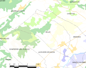
Bulle
Hiking in Bulle
Bulle, located in the Doubs region of France, offers a lovely variety of hiking opportunities that cater to different levels of experience and interests. The area is characterized by its stunning landscapes, lush forests, rolling hills, and beautiful lakes, making it an attractive destination for nature enthusiasts....
- Страна:
- Почтовый код: 25560
- Координаты: 46° 53' 38" N, 6° 13' 23" E
- GPS треки (wikiloc): [Ссылка]
- Площадь: 14.03 кв.км
- Население: 421

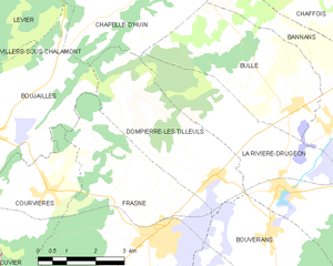
Dompierre-les-Tilleuls
- коммуна во Франции
Hiking in Dompierre-les-Tilleuls
Dompierre-les-Tilleuls is a charming village in the Jura region of France, known for its natural beauty and outdoor activities, including hiking. The area is characterized by rolling hills, forests, and scenic views, making it an excellent destination for hikers of all levels....
- Страна:
- Почтовый код: 25560
- Координаты: 46° 52' 18" N, 6° 11' 4" E
- GPS треки (wikiloc): [Ссылка]
- Площадь: 12.94 кв.км
- Население: 263


Sainte-Colombe
Hiking in Sainte-Colombe
Sainte-Colombe, located in the Doubs department in the Bourgogne-Franche-Comté region of France, offers a variety of beautiful hiking opportunities. The region is known for its stunning landscapes, including rolling hills, lush forests, and picturesque valleys....
- Страна:
- Почтовый код: 25300
- Координаты: 46° 52' 43" N, 6° 16' 3" E
- GPS треки (wikiloc): [Ссылка]
- Площадь: 10.49 кв.км
- Население: 387

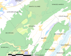
La Planée
- коммуна во Франции
Hiking in La Planée
Hiking in La Planée, located in the French Alps, offers stunning landscapes and diverse trails suitable for different skill levels. The area is known for its picturesque views, ranging from sweeping valleys to rugged mountain peaks....
- Страна:
- Почтовый код: 25160
- Координаты: 46° 50' 25" N, 6° 16' 55" E
- GPS треки (wikiloc): [Ссылка]
- Площадь: 13 кв.км
- Население: 261