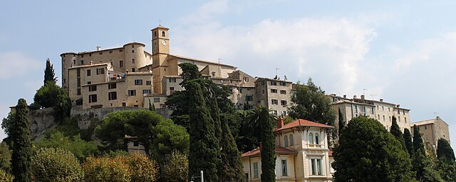
Сен-Блез (Saint-Blaise, Saint-Blaise)

- коммуна в департаменте Приморские Альпы, регион Прованс — Альпы — Лазурный Берег, Франция
 Hiking in Сен-Блез
Saint-Blaise, situated in the Alpes-Maritimes region of France, offers a beautiful backdrop for hiking enthusiasts. Nestled near Nice and the Mediterranean coast, it provides not only stunning views but also a variety of trails suitable for different skill levels.
Hiking Trails
-
Sentier de la Crête: This trail offers panoramic views of the coast and is wonderful for those looking to enjoy both the natural beauty and the picturesque landscapes of the Mediterranean. It connects different viewpoints and can vary in difficulty depending on the chosen route.
-
Les sentiers de la Vallee du Paillon: These trails meander through the lush valley and are generally more accessible for beginners and families. You can enjoy the flora and fauna of the region, with opportunities for bird watching and discovering local wildlife.
-
Mont Gros: For a more challenging hike, consider heading towards Mont Gros, which provides more demanding terrain. The ascents here reward you with spectacular views of the surrounding valleys and the coastline.
Best Time to Hike
The best times to hike in Saint-Blaise are during spring (April to June) and fall (September to October) when the temperatures are mild, and the scenery is vibrant with blooming flowers or autumn foliage. Summer can be quite hot, and some trails may become crowded, so early morning hikes are recommended during this season.
Tips for Hikers
- Gear Up: Wear sturdy hiking shoes and pack enough water. Depending on the season, sunscreen and a hat are advisable due to the sun exposure.
- Check Weather Conditions: The weather can change rapidly in the mountains, so it’s a good idea to check forecasts before heading out and be prepared for varying conditions.
- Stay on Marked Trails: To preserve the natural environment and ensure safety, stick to established paths.
- Respect Local Wildlife: Keep a safe distance from animals and avoid picking plants, as they are part of the delicate ecosystem.
Local Attractions
After hiking, consider exploring the quaint village of Saint-Blaise itself, known for its charming architecture and local cuisine. Enjoying a meal at a local bistro can be a delightful way to end your outdoor adventure.
Overall, hiking in Saint-Blaise is an enriching experience that combines physical activity with stunning natural beauty.
- Страна:

- Почтовый код: 06670
- Координаты: 43° 49' 18" N, 7° 14' 15" E


- GPS треки (wikiloc): [Ссылка]
- Площадь: 8.04 кв.км
- Население: 1013
- Википедия русская: wiki(ru)
- Википедия английская: wiki(en)
- Википедия национальная: wiki(fr)
- Хранилище Wikidata: Wikidata: Q1060287
- Катеория в википедии: [Ссылка]
- код Freebase: [/m/03m4z7n]
- код Freebase: [/m/03m4z7n]
- код GeoNames: Альт: [6618145]
- код GeoNames: Альт: [6618145]
- номер SIREN: [210601175]
- номер SIREN: [210601175]
- код VIAF: Альт: [153515439]
- код VIAF: Альт: [153515439]
- код муниципалитета INSEE: 06117
- код муниципалитета INSEE: 06117
Граничит с регионами:


Турет-Леван
- коммуна в департаменте Приморские Альпы, регион Прованс — Альпы — Лазурный Берег, Франция
Hiking in Турет-Леван
Tourrette-Levens is a charming commune located in the Alpes-Maritimes region of southeastern France, not far from Nice. It offers a delightful mix of hiking opportunities, showcasing stunning Mediterranean landscapes, hills, and views over the surrounding areas....
- Страна:
- Почтовый код: 06690
- Координаты: 43° 47' 12" N, 7° 16' 33" E
- GPS треки (wikiloc): [Ссылка]
- Площадь: 16.5 кв.км
- Население: 4877
- Веб сайт: [Ссылка]


Левенс
- коммуна в департаменте Приморские Альпы, регион Прованс — Альпы — Лазурный Берег, Франция
Hiking in Левенс
Levens, a small commune in the Alpes-Maritimes department in the Provence-Alpes-Côte d'Azur region of France, offers beautiful hiking opportunities surrounded by picturesque landscapes, including mountains and valleys. Here are some key highlights about hiking in and around Levens:...
- Страна:
- Почтовый код: 06670
- Координаты: 43° 51' 39" N, 7° 13' 28" E
- GPS треки (wikiloc): [Ссылка]
- Площадь: 29.85 кв.км
- Население: 4741

Кастанье
- коммуна в департаменте Приморские Альпы, регион Прованс — Альпы — Лазурный Берег, Франция
Hiking in Кастанье
Castagniers is a charming village located in the Alpes-Maritimes region of France, not far from Nice. It offers a mix of scenic views, cultural heritage, and well-marked hiking trails that cater to all levels of hikers....
- Страна:
- Почтовый код: 06670
- Координаты: 43° 47' 29" N, 7° 13' 54" E
- GPS треки (wikiloc): [Ссылка]
- Площадь: 7.52 кв.км
- Население: 1575
- Веб сайт: [Ссылка]


Ла-Рокет-сюр-Вар
- коммуна в департаменте Приморские Альпы, регион Прованс — Альпы — Лазурный Берег, Франция
Hiking in Ла-Рокет-сюр-Вар
La Roquette-sur-Var is a charming village located in the Alpes-Maritimes department in the Provence-Alpes-Côte d'Azur region of France. It offers access to beautiful natural landscapes, making it a great spot for hiking enthusiasts. Here are some highlights and tips for hiking in and around La Roquette-sur-Var:...
- Страна:
- Почтовый код: 06670
- Координаты: 43° 49' 41" N, 7° 11' 56" E
- GPS треки (wikiloc): [Ссылка]
- Площадь: 3.99 кв.км
- Население: 906

Карро
- коммуна в департаменте Приморские Альпы, регион Прованс — Альпы — Лазурный Берег, Франция
Hiking in Карро
Carros, located in the Alpes-Maritimes region of France near Nice, offers a variety of hiking opportunities that cater to all skill levels. The area is characterized by its stunning natural landscapes, including hills, forests, and panoramic views of the Mediterranean coast....
- Страна:
- Почтовый код: 06510
- Координаты: 43° 46' 21" N, 7° 11' 36" E
- GPS треки (wikiloc): [Ссылка]
- Площадь: 15.11 кв.км
- Население: 12008
- Веб сайт: [Ссылка]


Сен-Мартен-дю-Вар
- коммуна в департаменте Приморские Альпы, регион Прованс — Альпы — Лазурный Берег, Франция
Hiking in Сен-Мартен-дю-Вар
Saint-Martin-du-Var is a charming village located in the Alpes-Maritimes region of France, near Nice. The area is less known than more popular destinations in the French Riviera, making it a great spot for a peaceful hiking experience amidst stunning natural surroundings....
- Страна:
- Почтовый код: 06670
- Координаты: 43° 49' 20" N, 7° 11' 32" E
- GPS треки (wikiloc): [Ссылка]
- Площадь: 5.59 кв.км
- Население: 2882
- Веб сайт: [Ссылка]