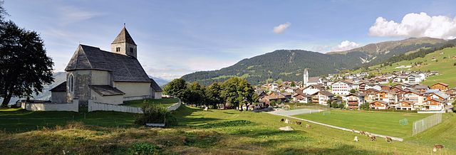
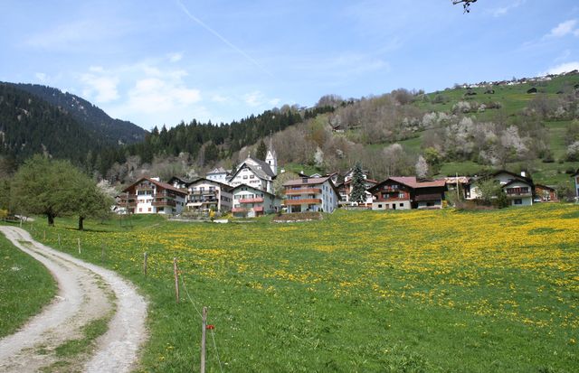
Ладир (Ladir, Ladir)

 Hiking in Ладир
Ladir is a stunning destination for hikers, known for its breathtaking landscapes and diverse trails. Whether you're seeking challenging mountain hikes or serene walks through lush valleys, Ladir offers a variety of options to suit all skill levels.
Key Hiking Trails
-
Ladir Mountain Trails: These trails range from moderate to challenging, featuring steep ascents and rocky paths. The views from the summit are rewarding, providing panoramic vistas of the surrounding areas.
-
Forest and River Walks: For those looking for a leisurely hike, the trails through forests and along rivers are perfect. These paths often have well-marked routes, and the cool shade makes them ideal for warmer days.
-
Long-Distance Routes: The region also boasts long-distance hiking options, which can connect you to neighboring areas, offering an opportunity to experience the local flora and fauna over several days.
Preparation Tips
- Weather Check: Before embarking, always check the local weather conditions, as they can change rapidly in mountainous regions.
- Gear Up: Wear appropriate hiking boots, and consider waterproof gear depending on the season.
- Stay Hydrated: Carry enough water, especially on longer trails where sources may be scarce.
- Safety First: Always let someone know your hiking plans and consider using a map or GPS device.
Local Highlights
- Flora and Fauna: Ladir is home to diverse ecosystems, so keep an eye out for unique plant species and local wildlife.
- Cultural Sites: Some trails may take you to historical sites or offer insight into the local culture, making your hike both scenic and educational.
Best Time to Hike
The best times for hiking in Ladir are typically during the spring and fall when the weather is mild and the scenery is at its most vibrant. Summer can be hot, while winter may bring snow to the higher elevations, making some trails impassable.
Enjoy your hiking adventures in Ladir, and always prioritize safety and respect for the natural environment!
- Страна:

- Почтовый код: 7155
- Телефонный код: 081
- Код автомобильного номера: GR
- Координаты: 46° 46' 59" N, 9° 11' 59" E


- GPS треки (wikiloc): [Ссылка]
- Высота над уровнем моря: 1276 м m
- Площадь: 7.19 кв.км
- Веб сайт: http://www.ladir.ch
- Википедия русская: wiki(ru)
- Википедия английская: wiki(en)
- Википедия национальная: wiki(de)
- Хранилище Wikidata: Wikidata: Q64743
- Катеория в википедии: [Ссылка]
- код Freebase: [/m/05q7fc]
- код GeoNames: Альт: [2660064]
- код VIAF: Альт: [237521621]
- ID отношения в OpenStreetMap: [1684098]
- идентификатор HDS: [1439]
- код швейцарского муниципалитета: [3576]
Граничит с регионами:

Фалера
Hiking in Фалера
Falera is a picturesque village in the Swiss Alps, located in the canton of Graubünden. The region is known for its breathtaking landscapes, rich history, and excellent hiking opportunities. Here’s what you should know about hiking in Falera:...
- Страна:
- Почтовый код: 7153
- Телефонный код: 081
- Код автомобильного номера: GR
- Координаты: 46° 49' 38" N, 9° 12' 31" E
- GPS треки (wikiloc): [Ссылка]
- Высота над уровнем моря: 1982 м m
- Площадь: 22.36 кв.км
- Население: 623
- Веб сайт: [Ссылка]

Шлуайн
Hiking in Шлуайн
Schluein is a picturesque village in the Graubünden region of Switzerland, nestled in the scenic Surselva area. It offers a variety of hiking opportunities, with stunning landscapes that include lush valleys, rugged mountains, and serene rivers....
- Страна:
- Почтовый код: 7151
- Телефонный код: 081
- Код автомобильного номера: GR
- Координаты: 46° 46' 59" N, 9° 13' 59" E
- GPS треки (wikiloc): [Ссылка]
- Высота над уровнем моря: 762 м m
- Площадь: 4.79 кв.км
- Население: 623
- Веб сайт: [Ссылка]


Шнаус
Hiking in Шнаус
Schnaus, located in the Swiss region of Graubünden, is renowned for its picturesque landscapes and diverse hiking trails. While specific trail information may vary, here’s a general guide to help you enjoy hiking in this beautiful area:...
- Страна:
- Почтовый код: 7130
- Телефонный код: 081
- Код автомобильного номера: GR
- Координаты: 46° 45' 59" N, 9° 9' 59" E
- GPS треки (wikiloc): [Ссылка]
- Высота над уровнем моря: 720 м m
- Площадь: 2.97 кв.км


Рушайн
Hiking in Рушайн
Ruschein, located in the Grisons region of Switzerland, offers beautiful landscapes and a variety of hiking trails suitable for all levels of experience. The area is characterized by stunning alpine scenery, including lush meadows, rugged mountains, and picturesque valleys....
- Страна:
- Почтовый код: 7154
- Телефонный код: 081
- Код автомобильного номера: GR
- Координаты: 46° 46' 59" N, 9° 11' 0" E
- GPS треки (wikiloc): [Ссылка]
- Высота над уровнем моря: 1155 м m
- Площадь: 12.54 кв.км
- Веб сайт: [Ссылка]