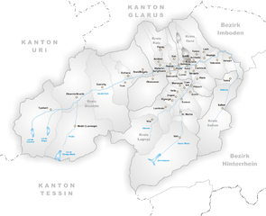
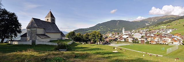
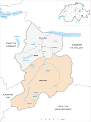
Рушайн (Ruschein, Ruschein)

 Hiking in Рушайн
Ruschein, located in the Grisons region of Switzerland, offers beautiful landscapes and a variety of hiking trails suitable for all levels of experience. The area is characterized by stunning alpine scenery, including lush meadows, rugged mountains, and picturesque valleys.
Hiking Trails in Ruschein:
-
Family-Friendly Trails:
- There are several easy trails designed for families and beginners, often featuring gentle inclines and breathtaking views. These trails are perfect for a leisurely hike or a picnic.
-
Intermediate Hikes:
- For those with some hiking experience, there are intermediate trails that might include moderate elevation gains and diverse terrain. These trails often lead to incredible viewpoints or charming villages.
-
Challenging Routes:
- Experienced hikers can tackle the more challenging routes that involve steep ascents and rugged paths. These hikes can lead you to some of the most breathtaking vantage points in the Alps.
Seasonal Considerations:
- Summer: Most trails are easily accessible, with blooming wildflowers and lovely weather.
- Autumn: The fall colors transform the landscape into a beautiful palette of yellows, reds, and oranges. It’s a great time for photography.
- Winter: Some trails may offer options for snowshoeing or winter hiking, but be prepared for cold temperatures and check local conditions for safety.
- Spring: Snow may still be present at higher elevations, but lower trails start to open up with greenery and wildflowers.
Preparation Tips:
- Gear: Wear appropriate hiking gear, including sturdy hiking boots, weather-appropriate clothing, and a good backpack.
- Maps & Navigation: It’s advisable to carry a map or use a reliable GPS app, as some trails may not be well marked.
- Hydration & Snacks: Always carry enough water and energy snacks, especially on longer hikes.
- Weather Conditions: Check the weather forecast before you set out, as mountain weather can change rapidly.
Safety:
- Always inform someone about your hiking plans.
- Stick to marked trails and be aware of your surroundings.
Hiking in Ruschein can be an unforgettable experience for nature lovers. Whether you seek tranquility in the great outdoors or an adrenaline rush from challenging hikes, this region has something to offer for everyone. Enjoy your adventure!
- Страна:

- Почтовый код: 7154
- Телефонный код: 081
- Код автомобильного номера: GR
- Координаты: 46° 46' 59" N, 9° 11' 0" E


- GPS треки (wikiloc): [Ссылка]
- Высота над уровнем моря: 1155 м m
- Площадь: 12.54 кв.км
- Веб сайт: http://www.ruschein.ch
- Википедия русская: wiki(ru)
- Википедия английская: wiki(en)
- Википедия национальная: wiki(de)
- Хранилище Wikidata: Wikidata: Q66006
- Катеория в википедии: [Ссылка]
- код Freebase: [/m/026gkrm]
- код GeoNames: Альт: [2658920]
- код VIAF: Альт: [130241587]
- ID отношения в OpenStreetMap: [1684144]
- код LCNAF: Альт: [n84222458]
- идентификатор HDS: [1443]
- код швейцарского муниципалитета: [3580]
Граничит с регионами:


Иланц
Hiking in Иланц
Ilanz, located in the beautiful Surselva region of the Swiss canton of Graubünden, offers a range of stunning hiking opportunities. Known as the "Gateway to the Rhine Canyon," Ilanz serves as a great base for exploring the surrounding natural landscapes. Here are some highlights and tips for hiking in the Ilanz area:...
- Страна:
- Почтовый код: 7130
- Телефонный код: 081
- Координаты: 46° 45' 59" N, 9° 12' 0" E
- GPS треки (wikiloc): [Ссылка]
- Высота над уровнем моря: 702 м m
- Площадь: 4.67 кв.км
- Веб сайт: [Ссылка]

Ладир
Hiking in Ладир
Ladir is a stunning destination for hikers, known for its breathtaking landscapes and diverse trails. Whether you're seeking challenging mountain hikes or serene walks through lush valleys, Ladir offers a variety of options to suit all skill levels....
- Страна:
- Почтовый код: 7155
- Телефонный код: 081
- Код автомобильного номера: GR
- Координаты: 46° 46' 59" N, 9° 11' 59" E
- GPS треки (wikiloc): [Ссылка]
- Высота над уровнем моря: 1276 м m
- Площадь: 7.19 кв.км
- Веб сайт: [Ссылка]

Фалера
Hiking in Фалера
Falera is a picturesque village in the Swiss Alps, located in the canton of Graubünden. The region is known for its breathtaking landscapes, rich history, and excellent hiking opportunities. Here’s what you should know about hiking in Falera:...
- Страна:
- Почтовый код: 7153
- Телефонный код: 081
- Код автомобильного номера: GR
- Координаты: 46° 49' 38" N, 9° 12' 31" E
- GPS треки (wikiloc): [Ссылка]
- Высота над уровнем моря: 1982 м m
- Площадь: 22.36 кв.км
- Население: 623
- Веб сайт: [Ссылка]

Шлуайн
Hiking in Шлуайн
Schluein is a picturesque village in the Graubünden region of Switzerland, nestled in the scenic Surselva area. It offers a variety of hiking opportunities, with stunning landscapes that include lush valleys, rugged mountains, and serene rivers....
- Страна:
- Почтовый код: 7151
- Телефонный код: 081
- Код автомобильного номера: GR
- Координаты: 46° 46' 59" N, 9° 13' 59" E
- GPS треки (wikiloc): [Ссылка]
- Высота над уровнем моря: 762 м m
- Площадь: 4.79 кв.км
- Население: 623
- Веб сайт: [Ссылка]


Шнаус
Hiking in Шнаус
Schnaus, located in the Swiss region of Graubünden, is renowned for its picturesque landscapes and diverse hiking trails. While specific trail information may vary, here’s a general guide to help you enjoy hiking in this beautiful area:...
- Страна:
- Почтовый код: 7130
- Телефонный код: 081
- Код автомобильного номера: GR
- Координаты: 46° 45' 59" N, 9° 9' 59" E
- GPS треки (wikiloc): [Ссылка]
- Высота над уровнем моря: 720 м m
- Площадь: 2.97 кв.км

Сиат
Hiking in Сиат
Siat is a charming village located in the picturesque region of the Swiss Alps. While it may not be as well-known as some major hiking destinations in Switzerland, it offers a range of beautiful trails and outdoor experiences for those looking to explore its stunning landscapes....
- Страна:
- Почтовый код: 7157
- Телефонный код: 081
- Код автомобильного номера: GR
- Координаты: 46° 46' 59" N, 9° 9' 0" E
- GPS треки (wikiloc): [Ссылка]
- Высота над уровнем моря: 1296 м m
- Площадь: 13.48 кв.км
- Население: 181
- Веб сайт: [Ссылка]


Лакс
Hiking in Лакс
Laax, located in the Swiss Alps in the canton of Graubünden, is a fantastic destination for hiking enthusiasts. Known for its breathtaking landscapes, diverse trails, and stunning alpine scenery, Laax offers hiking options for all skill levels. Here are some key aspects to consider if you're planning to hike in Laax:...
- Страна:
- Почтовый код: 7031
- Телефонный код: 081
- Код автомобильного номера: GR
- Координаты: 46° 50' 45" N, 9° 13' 40" E
- GPS треки (wikiloc): [Ссылка]
- Высота над уровнем моря: 1685 м m
- Площадь: 31.68 кв.км
- Население: 1755
- Веб сайт: [Ссылка]

Glarus Süd
Hiking in Glarus Süd
Glarus Süd, located in the canton of Glarus in Switzerland, is a fantastic destination for hiking enthusiasts. This region boasts stunning landscapes, ranging from lush valleys to rugged mountain terrains. Here are some key points about hiking in Glarus Süd:...
- Страна:
- Почтовый код: 8756, 8762, 8765, 8766, 8767, 8772, 8773, 8774, 8775, 8777, 8782, 8783, 8784
- Телефонный код: 055
- Код автомобильного номера: GL
- Координаты: 46° 59' 40" N, 9° 4' 27" E
- GPS треки (wikiloc): [Ссылка]
- Высота над уровнем моря: 521 м m
- Площадь: 430.2 кв.км
- Население: 9581
- Веб сайт: [Ссылка]