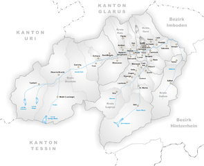
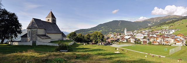
Шнаус (Schnaus, Schnaus)

 Hiking in Шнаус
Schnaus, located in the Swiss region of Graubünden, is renowned for its picturesque landscapes and diverse hiking trails. While specific trail information may vary, here’s a general guide to help you enjoy hiking in this beautiful area:
Hiking Trails
-
Scenic Views: Schnaus offers breathtaking views of the surrounding mountains, valleys, and lakes. Look for trails that lead to viewpoints or higher elevations for panoramic photography opportunities.
-
Trail Difficulty: There are trails suitable for all skill levels. Be sure to check the signage and trail maps before you head out. Beginners may enjoy easier paths while experienced hikers can tackle more challenging routes.
-
Popular Hikes:
- Valley Walks: Explore the lush valleys, which often feature winding rivers and rich flora.
- Summit Climbs: For the adventurous, consider hiking to nearby peaks that provide stunning views of the Alps.
Preparation
- Maps and Guides: It’s a good idea to obtain a local hiking map or use a hiking app to navigate the trails and ensure you stay on route.
- Gear: Wear sturdy hiking boots, dress in layers, and consider carrying a rain jacket, as weather can change quickly in the mountains.
- Hydration and Snacks: Bring plenty of water and energy-boosting snacks, especially for longer hikes.
Safety
- Inform Others: Always let someone know your hiking plans, especially if you're hiking alone.
- Wildlife: Be aware of the local wildlife and maintain a safe distance. Know what to do if you encounter any animals, particularly in the more remote areas.
- Emergency Services: Familiarize yourself with the local emergency contact numbers in case of accidents.
Timing
- Best Seasons: Late spring through early fall is ideal for hiking, as the weather is milder and trails are more accessible. Winter hiking is also an option but requires specialized gear.
Local Amenities
- Accommodations: Schnaus has various options for lodging, from cozy inns to guesthouses.
- Restaurants: Enjoy local Swiss cuisine to replenish your energy after a day of hiking.
Always check local regulations and trail conditions before your hike, as they can impact safety and accessibility. Enjoy your adventure in Schnaus!
- Страна:

- Почтовый код: 7130
- Телефонный код: 081
- Код автомобильного номера: GR
- Координаты: 46° 45' 59" N, 9° 9' 59" E


- GPS треки (wikiloc): [Ссылка]
- Высота над уровнем моря: 720 м m
- Площадь: 2.97 кв.км
- Википедия русская: wiki(ru)
- Википедия английская: wiki(en)
- Википедия национальная: wiki(de)
- Хранилище Wikidata: Wikidata: Q65694
- Катеория в википедии: [Ссылка]
- код Freebase: [/m/026gnd7]
- код GeoNames: Альт: [8533660]
- код VIAF: Альт: [244772584]
- ID отношения в OpenStreetMap: [1684161]
- идентификатор HDS: [1446]
- код швейцарского муниципалитета: [3583]
- LIR: [2692]
Граничит с регионами:


Иланц
Hiking in Иланц
Ilanz, located in the beautiful Surselva region of the Swiss canton of Graubünden, offers a range of stunning hiking opportunities. Known as the "Gateway to the Rhine Canyon," Ilanz serves as a great base for exploring the surrounding natural landscapes. Here are some highlights and tips for hiking in the Ilanz area:...
- Страна:
- Почтовый код: 7130
- Телефонный код: 081
- Координаты: 46° 45' 59" N, 9° 12' 0" E
- GPS треки (wikiloc): [Ссылка]
- Высота над уровнем моря: 702 м m
- Площадь: 4.67 кв.км
- Веб сайт: [Ссылка]

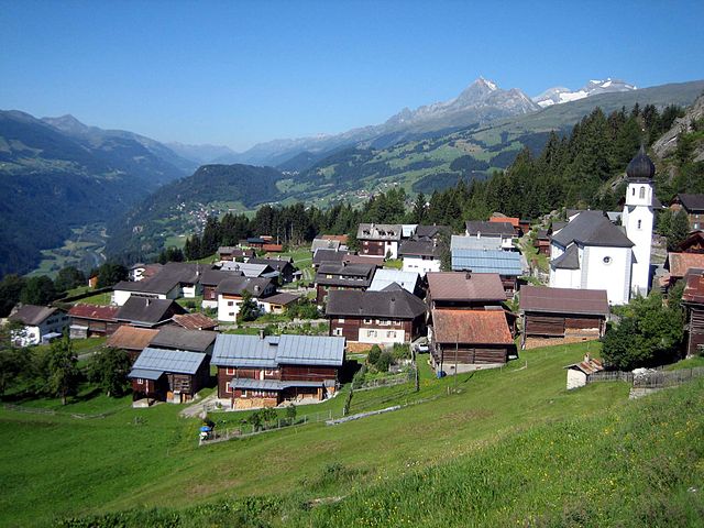
Ладир
Hiking in Ладир
Ladir is a stunning destination for hikers, known for its breathtaking landscapes and diverse trails. Whether you're seeking challenging mountain hikes or serene walks through lush valleys, Ladir offers a variety of options to suit all skill levels....
- Страна:
- Почтовый код: 7155
- Телефонный код: 081
- Код автомобильного номера: GR
- Координаты: 46° 46' 59" N, 9° 11' 59" E
- GPS треки (wikiloc): [Ссылка]
- Высота над уровнем моря: 1276 м m
- Площадь: 7.19 кв.км
- Веб сайт: [Ссылка]

Фалера
Hiking in Фалера
Falera is a picturesque village in the Swiss Alps, located in the canton of Graubünden. The region is known for its breathtaking landscapes, rich history, and excellent hiking opportunities. Here’s what you should know about hiking in Falera:...
- Страна:
- Почтовый код: 7153
- Телефонный код: 081
- Код автомобильного номера: GR
- Координаты: 46° 49' 38" N, 9° 12' 31" E
- GPS треки (wikiloc): [Ссылка]
- Высота над уровнем моря: 1982 м m
- Площадь: 22.36 кв.км
- Население: 623
- Веб сайт: [Ссылка]

Сиат
Hiking in Сиат
Siat is a charming village located in the picturesque region of the Swiss Alps. While it may not be as well-known as some major hiking destinations in Switzerland, it offers a range of beautiful trails and outdoor experiences for those looking to explore its stunning landscapes....
- Страна:
- Почтовый код: 7157
- Телефонный код: 081
- Код автомобильного номера: GR
- Координаты: 46° 46' 59" N, 9° 9' 0" E
- GPS треки (wikiloc): [Ссылка]
- Высота над уровнем моря: 1296 м m
- Площадь: 13.48 кв.км
- Население: 181
- Веб сайт: [Ссылка]


Руэун
Hiking in Руэун
Rueun is a picturesque village located in the Swiss canton of Graubünden, nestled among the stunning landscapes of the Swiss Alps. It serves as a great base for hiking enthusiasts looking to explore the natural beauty of the region. Here are some key points to know about hiking in and around Rueun:...
- Страна:
- Почтовый код: 7156
- Телефонный код: 081
- Код автомобильного номера: GR
- Координаты: 46° 45' 59" N, 9° 8' 59" E
- GPS треки (wikiloc): [Ссылка]
- Высота над уровнем моря: 788 м m
- Площадь: 11.58 кв.км
- Веб сайт: [Ссылка]


Рушайн
Hiking in Рушайн
Ruschein, located in the Grisons region of Switzerland, offers beautiful landscapes and a variety of hiking trails suitable for all levels of experience. The area is characterized by stunning alpine scenery, including lush meadows, rugged mountains, and picturesque valleys....
- Страна:
- Почтовый код: 7154
- Телефонный код: 081
- Код автомобильного номера: GR
- Координаты: 46° 46' 59" N, 9° 11' 0" E
- GPS треки (wikiloc): [Ссылка]
- Высота над уровнем моря: 1155 м m
- Площадь: 12.54 кв.км
- Веб сайт: [Ссылка]