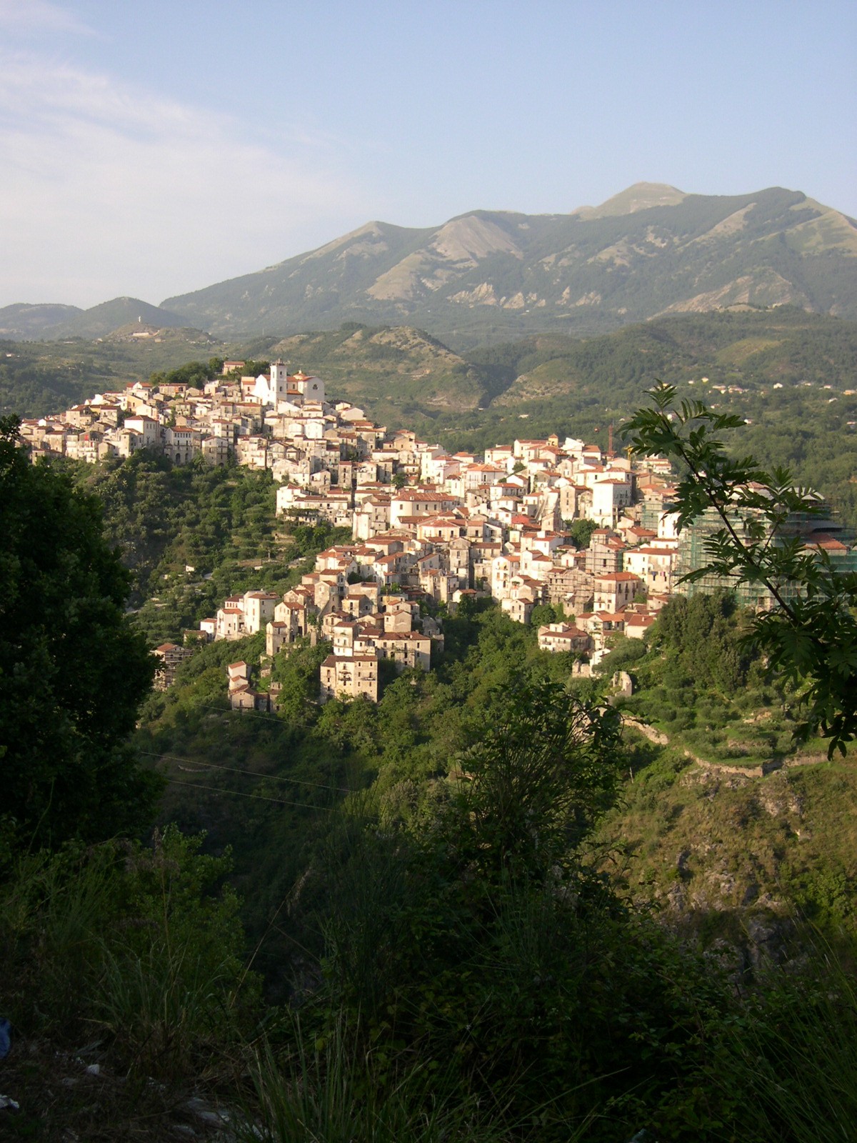
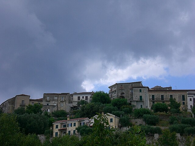
Лагонегро (Lagonegro, Lagonegro)
.svg)
- коммуна Италии
 Hiking in Лагонегро
Lagonegro is a beautiful town located in the southern Italian region of Basilicata, surrounded by stunning natural landscapes, mountains, and the Pollino National Park. Hiking in Lagonegro offers a variety of trails that cater to different experience levels, making it a fantastic destination for nature lovers and outdoor enthusiasts.
Key Highlights of Hiking in Lagonegro:
-
Pollino National Park: This is Italy's largest national park, rich in biodiversity and stunning scenery. It features rugged mountains, deep gorges, and a variety of flora and fauna. Numerous trails wind through the park, including routes that lead to the park's iconic peaks like Serra Dolcedorme and Monte Pollino.
-
Trail Options:
- Easy Trails: There are several easier paths suitable for families or beginners, providing picturesque scenery and shorter hiking times.
- Moderate Hiking: For those with some experience, you can find trails that offer a little more challenge, including steeper ascents and longer distances.
- Difficult Routes: Serious hikers will find challenging trails that require good physical fitness and navigation skills, offering breathtaking views and a true sense of adventure.
-
Cultural Elements: Hiking in Lagonegro also allows you to experience its rich cultural heritage. Some trails lead to historical sites, ancient hermitages, and quaint villages where you can sample local cuisine and traditions.
-
Flora and Fauna: The area is known for its diverse ecosystems. Keep an eye out for the unique wildlife that inhabits the park, including deer, eagles, and various plant species, some of which are endemic to the region.
-
Best Time to Hike: The ideal time for hiking in Lagonegro is during the spring (April to June) and fall (September to October) when the weather is generally mild, and the trails are less crowded. Summer can get hot, while winter may bring snow in higher elevations.
-
Guided Tours: For those unfamiliar with the area or looking for a richer experience, consider joining guided hiking tours. Local guides can provide insights into the ecology, geology, and history of the region.
Preparation Tips:
- Footwear: Wear sturdy hiking boots with good ankle support.
- Clothing: Dress in layers to accommodate changing temperatures and be prepared for rain.
- Hydration and Nutrition: Carry enough water and snacks to keep your energy levels up during the hike.
- Maps and Navigation: Although many trails are marked, having a map or GPS device can be helpful.
- Safety: Inform someone about your hiking plans and estimated return time, especially if you're hiking in remote areas.
Lagonegro and its surroundings present a wonderful opportunity to connect with nature and enjoy the serenity of the Italian landscape.
- Страна:

- Почтовый код: 85042
- Телефонный код: 0973
- Код автомобильного номера: PZ
- Координаты: 40° 8' 0" N, 15° 46' 0" E


- GPS треки (wikiloc): [Ссылка]
- Высота над уровнем моря: 666 м m
- Площадь: 113.07 кв.км
- Население: 5442
- Веб сайт: http://www.comune.lagonegro.pz.it/
- Википедия русская: wiki(ru)
- Википедия английская: wiki(en)
- Википедия национальная: wiki(it)
- Хранилище Wikidata: Wikidata: Q52586
- Катеория в википедии: [Ссылка]
- код Freebase: [/m/0fh3g4]
- код GeoNames: Альт: [6540774]
- код VIAF: Альт: [240549191]
- ID отношения в OpenStreetMap: [40289]
- место в MusicBrainz: [547a6f40-4e09-4267-bf6c-6fac0cea09fc]
- UN/LOCODE: [ITLAG]
- код Цифрового атласа Римской империи: [23171]
- код Pleiades: [442852]
- код ISTAT: 076039
- кадастровый код Италии: E409
Граничит с регионами:


Лаурия
- коммуна Италии
Hiking in Лаурия
Lauria is a beautiful location in the Basilicata region of southern Italy, known for its stunning landscapes, rich history, and outdoor activities, including hiking. The area offers a variety of trails suitable for different skill levels, from easy walks to more challenging hikes, all set against the backdrop of the Apennine mountains....
- Страна:
- Почтовый код: 85044
- Телефонный код: 0973
- Код автомобильного номера: PZ
- Координаты: 40° 2' 50" N, 15° 50' 9" E
- GPS треки (wikiloc): [Ссылка]
- Высота над уровнем моря: 430 м m
- Площадь: 176.63 кв.км
- Население: 12694
- Веб сайт: [Ссылка]


Молитерно
- коммуна Италии
Hiking in Молитерно
Moliterno is a small town in the Basilicata region of Southern Italy, nestled in the Appennine mountains. The area around Moliterno is known for its stunning natural landscapes, which provide excellent opportunities for hiking and outdoor activities....
- Страна:
- Почтовый код: 85047
- Телефонный код: 0975
- Код автомобильного номера: PZ
- Координаты: 40° 14' 24" N, 15° 51' 36" E
- GPS треки (wikiloc): [Ссылка]
- Высота над уровнем моря: 879 м m
- Площадь: 98.55 кв.км
- Население: 3916
- Веб сайт: [Ссылка]
Немоли
- коммуна Италии
Hiking in Немоли
Nemoli, located in the Basilicata region of Southern Italy, is a hidden gem for hiking enthusiasts. Nestled in the scenic landscape of the Pollino National Park, it offers stunning natural beauty, diverse wildlife, and a range of hiking trails suitable for various skill levels....
- Страна:
- Почтовый код: 85040
- Телефонный код: 0973
- Код автомобильного номера: PZ
- Координаты: 40° 4' 0" N, 15° 48' 0" E
- GPS треки (wikiloc): [Ссылка]
- Высота над уровнем моря: 421 м m
- Площадь: 19.49 кв.км
- Население: 1471
- Веб сайт: [Ссылка]

Ривелло
- коммуна Италии
Hiking in Ривелло
Rivello is a picturesque village located in the Basilicata region of southern Italy, known for its stunning landscapes and charming architecture. The area around Rivello offers various hiking opportunities that cater to different skill levels, appealing to both experienced hikers and those looking for leisurely walks....
- Страна:
- Почтовый код: 85040
- Телефонный код: 0973
- Код автомобильного номера: PZ
- Координаты: 40° 4' 42" N, 15° 45' 29" E
- GPS треки (wikiloc): [Ссылка]
- Высота над уровнем моря: 479 м m
- Площадь: 69.58 кв.км
- Население: 2731
- Веб сайт: [Ссылка]
Казальбуоно
- коммуна Италии
Hiking in Казальбуоно
Casalbuono, located in the scenic region of Basilicata in Italy, offers beautiful hiking opportunities due to its picturesque landscapes and rugged terrain. This area is known for its natural beauty, including forests, mountains, and valleys, which make it a great destination for outdoor enthusiasts....
- Страна:
- Почтовый код: 84030
- Телефонный код: 0975
- Код автомобильного номера: SA
- Координаты: 40° 12' 55" N, 15° 41' 20" E
- GPS треки (wikiloc): [Ссылка]
- Высота над уровнем моря: 661 м m
- Площадь: 34.82 кв.км
- Население: 1168
- Веб сайт: [Ссылка]


Казалетто-Спартано
- коммуна Италии
Hiking in Казалетто-Спартано
Casaletto Spartano, located in the Campania region of Italy, is a hidden gem for outdoor enthusiasts and hikers. Nestled in the charming Cilento and Vallo di Diano National Park, this area is characterized by its stunning landscapes, rich biodiversity, and cultural heritage. Here are some highlights about hiking in and around Casaletto Spartano:...
- Страна:
- Почтовый код: 84030
- Телефонный код: 0973
- Код автомобильного номера: SA
- Координаты: 40° 9' 0" N, 15° 37' 0" E
- GPS треки (wikiloc): [Ссылка]
- Высота над уровнем моря: 540 м m
- Площадь: 86.57 кв.км
- Население: 1376
- Веб сайт: [Ссылка]


Монтезано-сулла-Марчеллана
- коммуна Италии
Hiking in Монтезано-сулла-Марчеллана
Montesano sulla Marcellana is a charming town located in the province of Salerno in the Campania region of Italy. Nestled in the heart of the Cilento National Park, the area is rich in natural beauty, making it an excellent destination for hiking enthusiasts. Here are some key aspects to consider for hiking in and around Montesano sulla Marcellana:...
- Страна:
- Почтовый код: 84033
- Телефонный код: 0975
- Код автомобильного номера: SA
- Координаты: 40° 17' 0" N, 15° 42' 0" E
- GPS треки (wikiloc): [Ссылка]
- Высота над уровнем моря: 850 м m
- Площадь: 110.22 кв.км
- Население: 6544
- Веб сайт: [Ссылка]
Торторелла
- коммуна Италии
Hiking in Торторелла
Tortorella is a charming village located in the province of Salerno, in the Campania region of Italy. It's nestled in the beautiful landscapes of the Cilento and Vallo di Diano National Park, which offers a plethora of hiking opportunities. Here’s a guide to help you explore the hiking potential in and around Tortorella:...
- Страна:
- Почтовый код: 84030
- Телефонный код: 0973
- Код автомобильного номера: SA
- Координаты: 40° 8' 0" N, 15° 36' 0" E
- GPS треки (wikiloc): [Ссылка]
- Высота над уровнем моря: 582 м m
- Площадь: 34.22 кв.км
- Население: 506
- Веб сайт: [Ссылка]