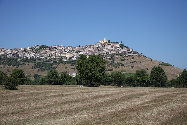
Молитерно (Moliterno, Moliterno)
.svg)
- коммуна Италии
 Hiking in Молитерно
Moliterno is a small town in the Basilicata region of Southern Italy, nestled in the Appennine mountains. The area around Moliterno is known for its stunning natural landscapes, which provide excellent opportunities for hiking and outdoor activities.
Hiking Trails
-
Monte Pierfaone: This mountain offers scenic trails that lead to panoramic views of the surrounding valleys. The ascent can be challenging but rewarding for seasoned hikers.
-
Parco Nazionale dell’Appennello Lucano: The national park nearby features a variety of trails suitable for different skill levels. You'll find lush forests, rivers, and diverse wildlife along these paths.
-
Vallo di Diano: Just a short drive from Moliterno, this area features breathtaking landscapes and trails that can lead you through historical sites and charming villages.
Best Time to Hike
- Spring (April to June): Ideal for wildflowers and pleasant temperatures.
- Fall (September to October): Offers stunning autumn foliage and cooler conditions, making for excellent hiking.
Tips for Hiking in Moliterno
- Wear appropriate footwear: Sturdy hiking boots are essential due to the rugged terrain.
- Check the weather: Southern Italy can have unpredictable weather; always check forecasts before heading out.
- Stay hydrated: Bring enough water, especially during the warmer months.
- Respect nature: Follow the Leave No Trace principles to preserve the environment.
Local Culture and Cuisine
After a long hike, you can enjoy local dishes, such as the famous "Pecorino di Moliterno" cheese, which is often paired with local bread and wines. Exploring the charming town’s historical sites, such as the medieval churches and the ancient castle ruins, can be a great way to relax after your outdoor adventures.
Overall, hiking in and around Moliterno offers a fantastic mix of natural beauty, outdoor activity, and cultural experiences. Enjoy your hike!
- Страна:

- Почтовый код: 85047
- Телефонный код: 0975
- Код автомобильного номера: PZ
- Координаты: 40° 14' 24" N, 15° 51' 36" E


- GPS треки (wikiloc): [Ссылка]
- Высота над уровнем моря: 879 м m
- Площадь: 98.55 кв.км
- Население: 3916
- Веб сайт: http://www.comune.moliterno.pz.it
- Википедия русская: wiki(ru)
- Википедия английская: wiki(en)
- Википедия национальная: wiki(it)
- Хранилище Wikidata: Wikidata: Q52609
- Катеория в википедии: [Ссылка]
- код Freebase: [/m/0c6081]
- код GeoNames: Альт: [6539002]
- код VIAF: Альт: [234819100]
- ID отношения в OpenStreetMap: [40322]
- код ISTAT: 076050
- кадастровый код Италии: F295
Граничит с регионами:
Кастельсарачено
- коммуна Италии
Hiking in Кастельсарачено
Castelsaraceno is a charming village located in the Basilicata region of southern Italy, nestled within the beautiful landscape of the Apennine Mountains. Hiking in and around Castelsaraceno offers a wonderful combination of natural beauty, historical significance, and diverse trails....
- Страна:
- Почтовый код: 85031
- Телефонный код: 0973
- Код автомобильного номера: PZ
- Координаты: 40° 10' 0" N, 15° 59' 0" E
- GPS треки (wikiloc): [Ссылка]
- Высота над уровнем моря: 960 м m
- Площадь: 74.78 кв.км
- Население: 1349
- Веб сайт: [Ссылка]

Грументо-Нова
- коммуна Италии
Hiking in Грументо-Нова
Grumento Nova, located in the Basilicata region of southern Italy, is an excellent destination for hiking enthusiasts. The area is rich in natural beauty, offering stunning landscapes, historical sites, and a variety of trails suitable for different skill levels. Here are some highlights for hiking in and around Grumento Nova:...
- Страна:
- Почтовый код: 85050
- Телефонный код: 0975
- Код автомобильного номера: PZ
- Координаты: 40° 17' 2" N, 15° 53' 23" E
- GPS треки (wikiloc): [Ссылка]
- Высота над уровнем моря: 771 м m
- Площадь: 66.65 кв.км
- Население: 1694
- Веб сайт: [Ссылка]
Лагонегро
- коммуна Италии
Hiking in Лагонегро
Lagonegro is a beautiful town located in the southern Italian region of Basilicata, surrounded by stunning natural landscapes, mountains, and the Pollino National Park. Hiking in Lagonegro offers a variety of trails that cater to different experience levels, making it a fantastic destination for nature lovers and outdoor enthusiasts....
- Страна:
- Почтовый код: 85042
- Телефонный код: 0973
- Код автомобильного номера: PZ
- Координаты: 40° 8' 0" N, 15° 46' 0" E
- GPS треки (wikiloc): [Ссылка]
- Высота над уровнем моря: 666 м m
- Площадь: 113.07 кв.км
- Население: 5442
- Веб сайт: [Ссылка]


Лаурия
- коммуна Италии
Hiking in Лаурия
Lauria is a beautiful location in the Basilicata region of southern Italy, known for its stunning landscapes, rich history, and outdoor activities, including hiking. The area offers a variety of trails suitable for different skill levels, from easy walks to more challenging hikes, all set against the backdrop of the Apennine mountains....
- Страна:
- Почтовый код: 85044
- Телефонный код: 0973
- Код автомобильного номера: PZ
- Координаты: 40° 2' 50" N, 15° 50' 9" E
- GPS треки (wikiloc): [Ссылка]
- Высота над уровнем моря: 430 м m
- Площадь: 176.63 кв.км
- Население: 12694
- Веб сайт: [Ссылка]
Саркони
- коммуна Италии
Hiking in Саркони
Sarconi, located in the Basilicata region of southern Italy, is known for its stunning natural landscapes, traditional rural architecture, and rich cultural heritage. Hiking in this area offers a unique blend of scenic views and the opportunity to explore local flora, fauna, and historical sites. Here are some aspects to consider when hiking in Sarconi:...
- Страна:
- Почтовый код: 85040
- Телефонный код: 0975
- Код автомобильного номера: PZ
- Координаты: 40° 15' 0" N, 15° 53' 0" E
- GPS треки (wikiloc): [Ссылка]
- Высота над уровнем моря: 636 м m
- Площадь: 30.69 кв.км
- Население: 1417
- Веб сайт: [Ссылка]
Трамутола
- коммуна Италии
Hiking in Трамутола
Tramutola is a charming village located in the Basilicata region of southern Italy, known for its scenic landscapes and rich natural beauty, making it an excellent destination for hiking enthusiasts. Here are some highlights and tips for hiking in and around Tramutola:...
- Страна:
- Почтовый код: 85057
- Телефонный код: 0975
- Код автомобильного номера: PZ
- Координаты: 40° 19' 0" N, 15° 47' 0" E
- GPS треки (wikiloc): [Ссылка]
- Высота над уровнем моря: 650 м m
- Площадь: 36.65 кв.км
- Население: 3033
- Веб сайт: [Ссылка]


Монтезано-сулла-Марчеллана
- коммуна Италии
Hiking in Монтезано-сулла-Марчеллана
Montesano sulla Marcellana is a charming town located in the province of Salerno in the Campania region of Italy. Nestled in the heart of the Cilento National Park, the area is rich in natural beauty, making it an excellent destination for hiking enthusiasts. Here are some key aspects to consider for hiking in and around Montesano sulla Marcellana:...
- Страна:
- Почтовый код: 84033
- Телефонный код: 0975
- Код автомобильного номера: SA
- Координаты: 40° 17' 0" N, 15° 42' 0" E
- GPS треки (wikiloc): [Ссылка]
- Высота над уровнем моря: 850 м m
- Площадь: 110.22 кв.км
- Население: 6544
- Веб сайт: [Ссылка]