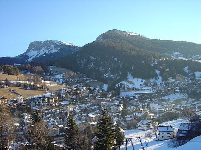
Лайон (Lajen, Laion)
.svg)
- коммуна Италии
 Hiking in Лайон
Lajen, or Laion, is a picturesque village located in the South Tyrol region of northern Italy, known for its stunning scenery and outdoor recreational opportunities, including hiking. The area is nestled in the Val Gardena valley, surrounded by the breathtaking Dolomites, a UNESCO World Heritage Site, which offers a wealth of hiking trails for all levels of experience.
Hiking Highlights in Lajen:
-
Trail Variety: Lajen offers a range of hiking trails that cater to different skill levels, from easy walks suitable for families to more challenging treks for experienced hikers. The trails often feature well-marked paths with beautiful views.
-
Scenic Beauty: Hikers can enjoy the dramatic landscapes of the Dolomites, with their unique rock formations, lush forests, quaint alpine pastures, and charming mountain huts. The area is also known for its biodiversity, including a variety of flora and fauna.
-
Cultural Experience: Hiking in Lajen also offers an opportunity to experience the local culture, including traditional South Tyrolean architecture and cuisine. You might find cozy mountain huts (Hütten) where you can stop for a meal or a drink.
-
Popular Trails: Some popular hiking routes near Lajen include:
- The Trail to the Raschötz Mountain: A moderate hike that offers stunning views of the surrounding Dolomites and valleys.
- The High-Altitude Trails: If you're looking for a more challenging experience, there are routes that take you into the high alpine regions.
-
Access to Other Trails: Lajen is conveniently located near other popular hiking areas such as the Puez-Odle Nature Park and the Seceda area, providing even more options for extensive hiking adventures.
-
Local Wildlife: Keep an eye out for local wildlife, including marmots, chamois, and a variety of bird species along the trails.
Hiking Tips:
- Season: The best time for hiking in Lajen is from late spring through early autumn when the weather is mild, and the trails are usually snow-free.
- Gear: Proper hiking footwear is essential, along with clothing suited for changing mountain weather. Always carry enough water and snacks.
- Map and Guidance: While trails are generally well-marked, carrying a map or using a GPS app can be helpful. Consider joining a guided hike if you’re unfamiliar with the area.
- Respect Nature: As with all outdoor activities, make sure to follow Leave No Trace principles to preserve the natural beauty of the area.
Exploring the hiking trails around Lajen can be a memorable experience filled with breathtaking views, rich culture, and the peaceful sounds of nature. Enjoy your hike!
- Страна:

- Почтовый код: 39040
- Телефонный код: 0471
- Код автомобильного номера: BZ
- Координаты: 46° 36' 29" N, 11° 33' 56" E


- GPS треки (wikiloc): [Ссылка]
- Высота над уровнем моря: 1093 м m
- Площадь: 37.53 кв.км
- Население: 2675
- Веб сайт: http://www.comune.laion.bz.it/system/web/default.aspx?sprache=3
- Википедия русская: wiki(ru)
- Википедия английская: wiki(en)
- Википедия национальная: wiki(it)
- Хранилище Wikidata: Wikidata: Q420006
- Галерея изображений в википедии: [Ссылка]
- Катеория в википедии: [Ссылка]
- код Freebase: [/m/0g9gv1]
- код GeoNames: Альт: [6535903]
- код VIAF: Альт: [312804255]
- ID отношения в OpenStreetMap: [47275]
- код GND: Альт: [4034140-9]
- идентификатор местоположения ArchINFORM: [15756]
- код ISTAT: 021039
- кадастровый код Италии: E420
Граничит с регионами:

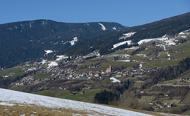
Ортизеи
- коммуна Италии
Hiking in Ортизеи
Urtijëi, also known as Ortisei, is a charming village located in the Val Gardena valley in South Tyrol, Italy. It's a popular base for hiking enthusiasts due to its stunning scenery, diverse trails, and proximity to the Dolomites, a UNESCO World Heritage site. Here are some highlights and tips for hiking in the Urtijëi area:...
- Страна:
- Почтовый код: 39046
- Телефонный код: 0471
- Код автомобильного номера: BZ
- Координаты: 46° 34' 0" N, 11° 40' 0" E
- GPS треки (wikiloc): [Ссылка]
- Высота над уровнем моря: 1230 м m
- Площадь: 24.16 кв.км
- Население: 4883
- Веб сайт: [Ссылка]

Фунес
- коммуна Италии
Hiking in Фунес
Villnöß, or Villnöß Valley, is a beautiful hiking destination located in South Tyrol, Northern Italy. Nestled at the foot of the Dolomites, it offers stunning landscapes, diverse trails, and an opportunity to experience both nature and local culture. Here are some highlights about hiking in this picturesque area:...
- Страна:
- Почтовый код: 39040
- Телефонный код: 0472
- Код автомобильного номера: BZ
- Координаты: 46° 38' 34" N, 11° 40' 42" E
- GPS треки (wikiloc): [Ссылка]
- Высота над уровнем моря: 1132 м m
- Площадь: 81.38 кв.км
- Население: 2603
- Веб сайт: [Ссылка]


Барбьяно
- коммуна Италии
Hiking in Барбьяно
Barbian, located in the South Tyrol region of northern Italy, is a beautiful destination for hiking enthusiasts. Nestled in the scenic Dolomites, Barbian offers a mix of well-marked trails that vary in difficulty, making it suitable for both beginners and experienced hikers....
- Страна:
- Почтовый код: 39040
- Телефонный код: 0471
- Код автомобильного номера: BZ
- Координаты: 46° 36' 12" N, 11° 31' 17" E
- GPS треки (wikiloc): [Ссылка]
- Высота над уровнем моря: 836 м m
- Площадь: 24.51 кв.км
- Население: 1699
- Веб сайт: [Ссылка]


Кастельротто
- коммуна Италии
Hiking in Кастельротто
Kastelruth, located in the beautiful Dolomites region of northern Italy, is a fantastic destination for hiking enthusiasts. The area is known for its stunning landscapes, diverse trails, and charming alpine villages. Here are some highlights and tips for hiking in Kastelruth:...
- Страна:
- Почтовый код: 39040
- Телефонный код: 0471
- Код автомобильного номера: BZ
- Координаты: 46° 34' 0" N, 11° 33' 40" E
- GPS треки (wikiloc): [Ссылка]
- Высота над уровнем моря: 2958 м m
- Площадь: 117.9 кв.км
- Население: 6872
- Веб сайт: [Ссылка]


Кьюза
- коммуна Италии
Hiking in Кьюза
Klausen (Chiusa) is a charming town located in South Tyrol, Italy, known for its stunning landscapes, rich history, and excellent hiking opportunities. Nestled in the Val Gardena valley, Klausen offers access to various hiking trails suitable for different skill levels. Here are some highlights about hiking in the area:...
- Страна:
- Почтовый код: 39043
- Телефонный код: 0472
- Код автомобильного номера: BZ
- Координаты: 46° 38' 24" N, 11° 33' 57" E
- GPS треки (wikiloc): [Ссылка]
- Высота над уровнем моря: 523 м m
- Площадь: 51.29 кв.км
- Население: 5211
- Веб сайт: [Ссылка]


Понте-Гардена
- коммуна в Италии
Hiking in Понте-Гардена
Waidbruck, a small village in South Tyrol, Italy, offers some beautiful hiking opportunities, combining stunning alpine scenery with rich cultural experiences. Here are some highlights and tips for hiking in the area:...
- Страна:
- Почтовый код: 39040
- Телефонный код: 0471
- Код автомобильного номера: BZ
- Координаты: 46° 35' 50" N, 11° 31' 51" E
- GPS треки (wikiloc): [Ссылка]
- Высота над уровнем моря: 471 м m
- Площадь: 2.33 кв.км
- Население: 193
- Веб сайт: [Ссылка]

Вилландро
- коммуна в Италии
Hiking in Вилландро
Villanders, located in South Tyrol, Italy, is a picturesque village that offers a variety of hiking opportunities amidst stunning alpine scenery. Here are some highlights for hiking in this area:...
- Страна:
- Почтовый код: 39043
- Телефонный код: 0472
- Код автомобильного номера: BZ
- Координаты: 46° 37' 51" N, 11° 32' 13" E
- GPS треки (wikiloc): [Ссылка]
- Высота над уровнем моря: 880 м m
- Площадь: 43.95 кв.км
- Население: 1853
- Веб сайт: [Ссылка]