
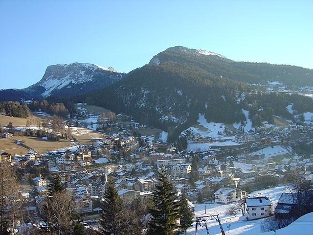
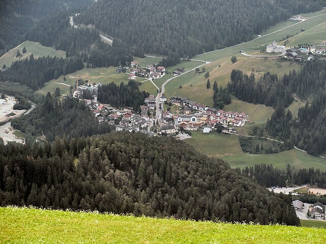
Фунес (Villnöß, Funes)
.svg)
- коммуна Италии
 Hiking in Фунес
Villnöß, or Villnöß Valley, is a beautiful hiking destination located in South Tyrol, Northern Italy. Nestled at the foot of the Dolomites, it offers stunning landscapes, diverse trails, and an opportunity to experience both nature and local culture. Here are some highlights about hiking in this picturesque area:
Scenic Trails
-
Seceda: This is a popular hike that offers breathtaking views of the Dolomites. The trail to the Seceda plateau can be challenging but rewards you with panoramic views and opportunities for photography.
-
Geisler Alm: A moderate hike leads you to the stunning Geisler Alm, where you can enjoy views of the Geisler Peaks. This area is perfect for families and features charming alpine huts serving traditional Tyrolean cuisine.
-
Villnöß Valley Trail: Ideal for a more leisurely walk, this trail runs the length of the valley and showcases beautiful meadows, forests, and dramatic mountain scenery. It's particularly great for seeing wildflowers in late spring and summer.
-
Peitlerkofel: For experienced hikers, the ascent to Peitlerkofel is a must. This mountain offers a variety of routes, each presenting unique challenges and stunning vistas.
Flora and Fauna
The region is rich in biodiversity. As you hike, you may encounter a variety of wildlife, including chamois, marmots, and numerous bird species. The area is also known for its rich alpine flora, making it a great spot for nature lovers.
Local Culture
Villnöß is also steeped in Tyrolean culture. You can take breaks at various mountain huts, where you can taste local cheeses, speck, and traditional desserts. The valley is home to several charming villages with historical architecture, adding to the scenic experience.
Best Time to Hike
The best times to hike in Villnöß are late spring through early autumn. July and August are perfect for full-day hikes, while late spring and early fall offer beautiful weather with fewer crowds.
Tips for Hikers
- Map and Routes: Always have a good map or GPS guide. Familiarize yourself with the routes, and choose ones appropriate to your skill level.
- Equipment: Wear sturdy hiking boots and carry trekking poles if needed. Don’t forget sun protection, water, and snacks.
- Weather: Be prepared for changing weather conditions, especially in the mountains. Layered clothing is advisable.
Accessibility
Villnöß is accessible by public transport, and many trails are well-marked and frequented. Some areas may also have cable cars that can help you reach higher altitudes with ease.
Hiking in Villnöß offers a mixture of adventure, stunning landscapes, and cultural experiences, making it a perfect destination for hikers of all levels. Enjoy your time exploring this beautiful valley!
- Страна:

- Почтовый код: 39040
- Телефонный код: 0472
- Код автомобильного номера: BZ
- Координаты: 46° 38' 34" N, 11° 40' 42" E


- GPS треки (wikiloc): [Ссылка]
- Высота над уровнем моря: 1132 м m
- Площадь: 81.38 кв.км
- Население: 2603
- Веб сайт: http://www.funes.eu
- Википедия русская: wiki(ru)
- Википедия английская: wiki(en)
- Википедия национальная: wiki(it)
- Хранилище Wikidata: Wikidata: Q261187
- Галерея изображений в википедии: [Ссылка]
- Катеория в википедии: [Ссылка]
- код Freebase: [/m/0g9gp8]
- код GeoNames: Альт: [6536011]
- код VIAF: Альт: [316877276]
- ID отношения в OpenStreetMap: [47277]
- код GND: Альт: [4512594-6]
- идентификатор местоположения ArchINFORM: [12848]
- код ISTAT: 021033
- кадастровый код Италии: D821
Граничит с регионами:


Брессаноне
- коммуна Италии
Hiking in Брессаноне
Brixen, also known as Bressanone, is a charming town located in the South Tyrol region of northern Italy. It's surrounded by the beautiful Dolomites, making it a fantastic destination for hiking enthusiasts. Here are some highlights about hiking in and around Brixen:...
- Страна:
- Почтовый код: 39042
- Телефонный код: 0472
- Код автомобильного номера: BZ
- Координаты: 46° 43' 0" N, 11° 39' 0" E
- GPS треки (wikiloc): [Ссылка]
- Высота над уровнем моря: 560 м m
- Площадь: 84.7 кв.км
- Население: 21688
- Веб сайт: [Ссылка]

Ортизеи
- коммуна Италии
Hiking in Ортизеи
Urtijëi, also known as Ortisei, is a charming village located in the Val Gardena valley in South Tyrol, Italy. It's a popular base for hiking enthusiasts due to its stunning scenery, diverse trails, and proximity to the Dolomites, a UNESCO World Heritage site. Here are some highlights and tips for hiking in the Urtijëi area:...
- Страна:
- Почтовый код: 39046
- Телефонный код: 0471
- Код автомобильного номера: BZ
- Координаты: 46° 34' 0" N, 11° 40' 0" E
- GPS треки (wikiloc): [Ссылка]
- Высота над уровнем моря: 1230 м m
- Площадь: 24.16 кв.км
- Население: 4883
- Веб сайт: [Ссылка]


Кьюза
- коммуна Италии
Hiking in Кьюза
Klausen (Chiusa) is a charming town located in South Tyrol, Italy, known for its stunning landscapes, rich history, and excellent hiking opportunities. Nestled in the Val Gardena valley, Klausen offers access to various hiking trails suitable for different skill levels. Here are some highlights about hiking in the area:...
- Страна:
- Почтовый код: 39043
- Телефонный код: 0472
- Код автомобильного номера: BZ
- Координаты: 46° 38' 24" N, 11° 33' 57" E
- GPS треки (wikiloc): [Ссылка]
- Высота над уровнем моря: 523 м m
- Площадь: 51.29 кв.км
- Население: 5211
- Веб сайт: [Ссылка]


Лайон
- коммуна Италии
Hiking in Лайон
Lajen, or Laion, is a picturesque village located in the South Tyrol region of northern Italy, known for its stunning scenery and outdoor recreational opportunities, including hiking. The area is nestled in the Val Gardena valley, surrounded by the breathtaking Dolomites, a UNESCO World Heritage Site, which offers a wealth of hiking trails for all levels of experience....
- Страна:
- Почтовый код: 39040
- Телефонный код: 0471
- Код автомобильного номера: BZ
- Координаты: 46° 36' 29" N, 11° 33' 56" E
- GPS треки (wikiloc): [Ссылка]
- Высота над уровнем моря: 1093 м m
- Площадь: 37.53 кв.км
- Население: 2675
- Веб сайт: [Ссылка]

Сан-Мартино-ин-Бадия
- коммуна в Италии
Hiking in Сан-Мартино-ин-Бадия
San Martin de Tor, located in the Dolomites of Northern Italy, is an excellent destination for hiking enthusiasts. The area is known for its stunning landscapes, rich cultural heritage, and a variety of trails that cater to different skill levels. Here are some highlights and tips for hiking in and around San Martin de Tor:...
- Страна:
- Почтовый код: 39030
- Телефонный код: 0474
- Код автомобильного номера: BZ
- Координаты: 46° 40' 54" N, 11° 53' 53" E
- GPS треки (wikiloc): [Ссылка]
- Высота над уровнем моря: 1127 м m
- Площадь: 75.94 кв.км
- Население: 1744
- Веб сайт: [Ссылка]


Вельтурно
- коммуна в Италии
Hiking in Вельтурно
Feldthurns (or Velthurns) is a quaint village located in South Tyrol, Italy, known for its stunning landscapes and excellent hiking opportunities. Nestled within the foothills of the Alps, it provides access to various trails that cater to different skill levels, making it an excellent destination for both novice hikers and seasoned trekkers....
- Страна:
- Почтовый код: 39040
- Телефонный код: 0472
- Код автомобильного номера: BZ
- Координаты: 46° 40' 1" N, 11° 35' 50" E
- GPS треки (wikiloc): [Ссылка]
- Высота над уровнем моря: 851 м m
- Площадь: 24.58 кв.км
- Население: 2873
- Веб сайт: [Ссылка]


Санта-Кристина-Вальгардена
- коммуна в Италии
Hiking in Санта-Кристина-Вальгардена
Santa Cristina Gherdëina, located in the Dolomites of northern Italy, is a beautiful destination for hiking enthusiasts. The stunning landscape, dramatic peaks, and vibrant alpine scenery provide an incredible backdrop for a variety of hiking trails, suitable for all skill levels. Here are some highlights and tips if you’re considering hiking in this region:...
- Страна:
- Почтовый код: 39047
- Телефонный код: 0471
- Код автомобильного номера: BZ
- Координаты: 46° 33' 47" N, 11° 43' 56" E
- GPS треки (wikiloc): [Ссылка]
- Высота над уровнем моря: 1428 м m
- Площадь: 31.92 кв.км
- Население: 1961
- Веб сайт: [Ссылка]