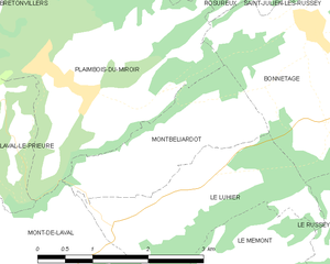
Le Luhier (Le Luhier)

- коммуна во Франции
 Hiking in Le Luhier
Le Luhier is a picturesque region that offers a variety of hiking trails for both beginners and experienced hikers. Nestled in nature, this area features stunning landscapes, including dense forests, rolling hills, and picturesque streams. While I don’t have specific details on Le Luhier itself, I can give you some general tips and advice for hiking in such areas.
Trail Information:
- Types of Trails: Look for marked trails that vary in difficulty. There might be easy walks suitable for families and challenging routes that offer breathtaking views for the more adventurous.
- Trail Maps: Always carry a map of the area or download a trail app. This will help you navigate efficiently and ensure you don’t get lost.
Safety Tips:
- Weather Awareness: Check the forecast before heading out. Weather can change rapidly, especially in mountainous regions.
- Gear: Wear appropriate footwear (hiking boots are recommended) and dress in layers to accommodate temperature changes.
- Hydration and Snacks: Carry enough water and high-energy snacks to keep your energy levels up.
- Emergency Kit: It’s wise to have a small first-aid kit and a whistle on hand in case of emergencies.
Wildlife and Nature:
- Wildlife Viewing: Be respectful of the local wildlife. Maintain a safe distance and do not feed animals.
- Leave No Trace: Follow the Leave No Trace principles to preserve the natural beauty of the area. This includes packing out all trash and staying on designated paths.
Local Attractions:
- Check for any viewpoints, historical sites, or unique natural features along the trails that you might want to explore.
Getting There:
- Transportation: Make sure you know the best routes for getting to Le Luhier, whether by car, public transport, or shuttle service.
Before you set out, consider reaching out to local hiking clubs or visitor centers for detailed information on specific trails, current conditions, and additional tips for enjoying your time in Le Luhier. Happy hiking!
- Страна:

- Почтовый код: 25210
- Координаты: 47° 10' 6" N, 6° 39' 34" E


- GPS треки (wikiloc): [Ссылка]
- Площадь: 5.21 кв.км
- Население: 212
- Википедия английская: wiki(en)
- Википедия национальная: wiki(fr)
- Хранилище Wikidata: Wikidata: Q654681
- Катеория в википедии: [Ссылка]
- код Freebase: [/m/03mhb7r]
- код Freebase: [/m/03mhb7r]
- код GeoNames: Альт: [6455723]
- код GeoNames: Альт: [6455723]
- номер SIREN: [212503510]
- номер SIREN: [212503510]
- код BNF: [15252577p]
- код BNF: [15252577p]
- код муниципалитета INSEE: 25351
- код муниципалитета INSEE: 25351
Граничит с регионами:

Montbéliardot
- коммуна во Франции
Hiking in Montbéliardot
Montbéliardot is a beautiful area that is not widely known among hikers, but it offers natural beauty, picturesque landscapes, and opportunities for outdoor activities. While detailed hiking trails may not be specifically documented for Montbéliardot, the surrounding regions in the Doubs department and nearby areas can provide excellent hiking experiences....
- Страна:
- Почтовый код: 25210
- Координаты: 47° 10' 31" N, 6° 39' 16" E
- GPS треки (wikiloc): [Ссылка]
- Площадь: 3.8 кв.км
- Население: 114


Le Russey
- коммуна во Франции
Hiking in Le Russey
Le Russey is a charming commune located in the Doubs department in the Bourgogne-Franche-Comté region of eastern France. It's nestled in a picturesque part of the Jura Mountains, which offers a variety of scenic hiking opportunities. Here are some points to consider when hiking in and around Le Russey:...
- Страна:
- Почтовый код: 25210
- Координаты: 47° 9' 46" N, 6° 43' 48" E
- GPS треки (wikiloc): [Ссылка]
- Площадь: 24.17 кв.км
- Население: 2282
- Веб сайт: [Ссылка]


Mont-de-Laval
- коммуна во Франции
Hiking in Mont-de-Laval
Mont-de-Laval is situated in the beautiful region of the French Alps, and offers a variety of hiking opportunities that cater to different skill levels. Here are some highlights regarding hiking in the area:...
- Страна:
- Почтовый код: 25210
- Координаты: 47° 10' 10" N, 6° 37' 41" E
- GPS треки (wikiloc): [Ссылка]
- Площадь: 8.44 кв.км
- Население: 173