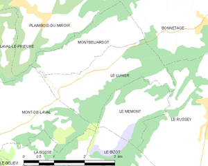
Le Russey (Le Russey)

- коммуна во Франции
 Hiking in Le Russey
Le Russey is a charming commune located in the Doubs department in the Bourgogne-Franche-Comté region of eastern France. It's nestled in a picturesque part of the Jura Mountains, which offers a variety of scenic hiking opportunities. Here are some points to consider when hiking in and around Le Russey:
Trails and Routes
-
Local Trails: The area around Le Russey offers several well-marked hiking trails that cater to different skill levels. These paths often lead through lush forests, rolling hills, and open meadows, providing both mild and more challenging hikes.
-
Jura Natural Park: A short distance from Le Russey, Jura Natural Regional Park features diverse landscapes, including limestone cliffs, lakes, and extensive forests. There are multiple trails ranging from easy walks to more strenuous hikes, perfect for exploring the natural beauty of the region.
-
Signage and Maps: Many trails in this area are well-marked with signposts, making it easier for hikers to navigate. It's beneficial to carry a detailed map or download a hiking app that covers this region.
Flora and Fauna
- The region is rich in biodiversity, and hikers might encounter various wildlife, including deer, foxes, and numerous bird species. The flora includes a mix of deciduous and coniferous trees, wildflowers, and a variety of plants native to the Jura region.
Best Seasons to Hike
- Spring and Fall: These seasons are ideal for hiking due to mild temperatures and stunning scenery. Spring brings blooming flowers, while fall offers vibrant colors as the leaves change.
- Summer: While warm, be cautious of higher temperatures and be sure to carry enough water.
- Winter: In winter, some trails may be suitable for snowshoeing, but it's essential to check conditions and be prepared for colder weather.
Preparing for Your Hike
-
Gear: Wear sturdy hiking shoes and weather-appropriate clothing. It's also wise to layer your clothing, as temperatures can fluctuate throughout the day.
-
Essentials: Bring plenty of water, snacks, a first-aid kit, and a map or GPS device. If hiking during off-peak hours or in remote areas, consider letting someone know your plans.
-
Local Regulations: Always follow local guidelines and regulations, which may include restrictions on campfires, wildlife protection, and trail etiquette.
Additional Activities
- Cultural Sites: In addition to hiking, consider exploring local cultural sites and enjoying the cuisine of the region. Visiting nearby towns can enrich your experience of the area.
Le Russey and its surrounding natural beauty make for a peaceful and rewarding hiking experience. Remember to respect nature and enjoy the tranquility of this beautiful region!
- Страна:

- Почтовый код: 25210
- Координаты: 47° 9' 46" N, 6° 43' 48" E


- GPS треки (wikiloc): [Ссылка]
- Площадь: 24.17 кв.км
- Население: 2282
- Веб сайт: http://www.lerussey.fr/
- Википедия английская: wiki(en)
- Википедия национальная: wiki(fr)
- Хранилище Wikidata: Wikidata: Q837507
- Катеория в википедии: [Ссылка]
- код Freebase: [/m/03mhckp]
- код Freebase: [/m/03mhckp]
- код GeoNames: Альт: [6455730]
- код GeoNames: Альт: [6455730]
- номер SIREN: [212505127]
- номер SIREN: [212505127]
- код BNF: [15252738b]
- код BNF: [15252738b]
- код VIAF: Альт: [239193542]
- код VIAF: Альт: [239193542]
- код муниципалитета INSEE: 25512
- код муниципалитета INSEE: 25512
Граничит с регионами:


Le Bizot
- коммуна во Франции
Hiking in Le Bizot
Le Bizot is a small village located in the eastern part of France, in the Bourgogne-Franche-Comté region. It’s not typically a major hiking destination, but its surroundings offer beautiful landscapes and opportunities for outdoor activities, including hiking....
- Страна:
- Почтовый код: 25210
- Координаты: 47° 8' 9" N, 6° 40' 18" E
- GPS треки (wikiloc): [Ссылка]
- Площадь: 7.85 кв.км
- Население: 302

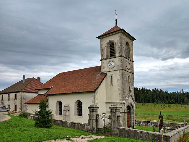
Le Luhier
- коммуна во Франции
Hiking in Le Luhier
Le Luhier is a picturesque region that offers a variety of hiking trails for both beginners and experienced hikers. Nestled in nature, this area features stunning landscapes, including dense forests, rolling hills, and picturesque streams. While I don’t have specific details on Le Luhier itself, I can give you some general tips and advice for hiking in such areas....
- Страна:
- Почтовый код: 25210
- Координаты: 47° 10' 6" N, 6° 39' 34" E
- GPS треки (wikiloc): [Ссылка]
- Площадь: 5.21 кв.км
- Население: 212

Le Mémont
- коммуна во Франции
Hiking in Le Mémont
Le Mémont is a scenic hiking destination located in the Vosges region of France. Known for its beautiful landscapes, lush forests, and panoramic views, it offers a variety of trails suitable for different skill levels....
- Страна:
- Почтовый код: 25210
- Координаты: 47° 9' 22" N, 6° 40' 54" E
- GPS треки (wikiloc): [Ссылка]
- Высота над уровнем моря: 1000 м m
- Площадь: 3.16 кв.км
- Население: 41


Le Barboux
- коммуна во Франции
Hiking in Le Barboux
Le Barboux is a charming village located in the Auvergne-Rhône-Alpes region of France, known for its beautiful natural scenery and outdoor activities, including hiking. The area is characterized by rolling hills, forests, and stunning views of the surrounding mountains, making it an ideal destination for hikers of all levels....
- Страна:
- Почтовый код: 25210
- Координаты: 47° 7' 14" N, 6° 43' 1" E
- GPS треки (wikiloc): [Ссылка]
- Площадь: 11.26 кв.км
- Население: 251


Bonnétage
- коммуна во Франции
Hiking in Bonnétage
Bonnétage, located in the Doubs department of the Bourgogne-Franche-Comté region in eastern France, is a beautiful destination for hiking enthusiasts. Nestled in the Jura Mountains, the area offers stunning landscapes, lush forests, and panoramic views, making it an ideal location for outdoor activities....
- Страна:
- Почтовый код: 25210
- Координаты: 47° 11' 5" N, 6° 43' 24" E
- GPS треки (wikiloc): [Ссылка]
- Площадь: 17.71 кв.км
- Население: 887
Grand'Combe-des-Bois
- коммуна во Франции
Hiking in Grand'Combe-des-Bois
Grand'Combe-des-Bois, located in the Doubs department in the Bourgogne-Franche-Comté region of eastern France, offers a picturesque setting for hiking enthusiasts. Known for its stunning natural landscapes, the area features rolling hills, dense forests, and a variety of wildlife, making it ideal for outdoor activities....
- Страна:
- Почтовый код: 25210
- Координаты: 47° 8' 16" N, 6° 47' 27" E
- GPS треки (wikiloc): [Ссылка]
- Площадь: 11.87 кв.км
- Население: 137


Narbief
- коммуна во Франции
Hiking in Narbief
Narbief is a beautiful area located in the French Jura region, known for its stunning landscapes and outdoor activities, including hiking. The region offers a variety of trails that cater to different skill levels, from casual walks to more challenging hikes. Here are some key points to consider when hiking in Narbief:...
- Страна:
- Почтовый код: 25210
- Координаты: 47° 7' 45" N, 6° 41' 27" E
- GPS треки (wikiloc): [Ссылка]
- Площадь: 3.47 кв.км
- Население: 66