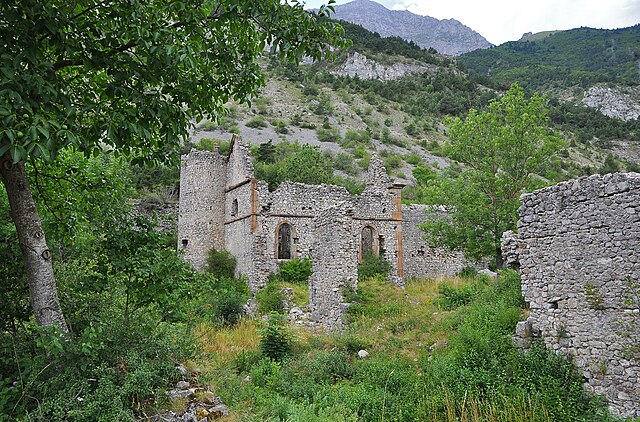
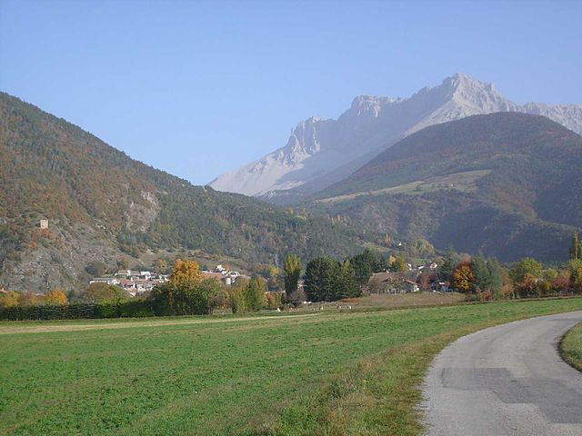
Сент-Этьен-ан-Деволюи (Saint-Étienne-en-Dévoluy, Saint-Étienne-en-Dévoluy)
- коммуна во Франции
 Hiking in Сент-Этьен-ан-Деволюи
Saint-Étienne-en-Dévoluy is a lovely destination for hiking, located in the Dévoluy massif in the French Alps. This area offers a variety of trails suitable for all levels, from gentle walks to more challenging hikes, making it a perfect place for both beginners and experienced hikers.
Key Features of Hiking in Saint-Étienne-en-Dévoluy:
-
Scenic Landscapes: The region is characterized by stunning alpine scenery, including dramatic peaks, beautiful valleys, and diverse flora and fauna. The views can be especially breathtaking in the summer months when the wildflowers are in bloom.
-
Variety of Trails: There are numerous marked trails, ranging in difficulty from easy family-friendly walks to challenging mountain hikes. Some popular routes include:
- Le Collet trail, which offers panoramic views of the surrounding mountains.
- Lac de la Cougourde, an alpine lake that is perfect for a day hike.
- Sentier des Loups, which provides a chance to see local wildlife.
-
Access to the Ancelle Ski Resort: In addition to hiking, the area is also home to ski resorts, offering year-round outdoor activities. In the summer, hiking trails often merge with biking and horse-riding routes.
-
Wildlife Watching: The Dévoluy region is known for its diverse wildlife, including chamois, ibex, and various bird species. Early mornings or late evenings are usually the best times to spot wildlife.
-
Local Culture and Food: After a day of hiking, you can enjoy the local Alpine cuisine in the nearby villages. Don't miss out on trying local cheeses, cured meats, and other regional specialties.
-
Guided Tours and Maps: If you’re new to hiking or unfamiliar with the area, consider joining a guided hiking tour. Local guides can provide insight into the geography, flora, and fauna of the region. Trail maps are often available at local tourist offices or online.
Tips for Hiking in Saint-Étienne-en-Dévoluy:
- Prepare for Weather Changes: The weather in the mountains can change rapidly, so be sure to check forecasts and dress in layers.
- Stay Hydrated: Bring enough water, especially on longer hikes, as some trails may not have water sources along the way.
- Respect Nature: Follow the Leave No Trace principles; pack out what you pack in, and stick to marked trails to protect the ecosystem.
Hiking in Saint-Étienne-en-Dévoluy can be a rewarding experience, offering both adventure and peaceful moments in nature. Whether you're looking for a short stroll or an adventurous trek, the area has something to offer everyone.
- Страна:

- Почтовый код: 05250
- Координаты: 44° 41' 36" N, 5° 56' 31" E


- GPS треки (wikiloc): [Ссылка]
- Население: 525
- Веб сайт: http://www.stetiennedevoluy.com/
- Википедия русская: wiki(ru)
- Википедия английская: wiki(en)
- Википедия национальная: wiki(fr)
- Хранилище Wikidata: Wikidata: Q780103
- Катеория в википедии: [Ссылка]
- код Freebase: [/m/03mfp4c]
- код Freebase: [/m/03mfp4c]
- код Freebase: [/m/03mfp4c]
- код GeoNames: Альт: [2980230]
- код GeoNames: Альт: [2980230]
- код GeoNames: Альт: [2980230]
- код муниципалитета INSEE: 05139
- код муниципалитета INSEE: 05139
- код муниципалитета INSEE: 05139
Граничит с регионами:
Ле-Глезий
- коммуна во Франции
Hiking in Ле-Глезий
Le Glaizil is a picturesque commune located in the Hautes-Alpes department in southeastern France. The surrounding area is known for its stunning landscapes, including mountains, valleys, and diverse flora and fauna, which make it a great destination for hiking enthusiasts....
- Страна:
- Почтовый код: 05800
- Координаты: 44° 45' 13" N, 5° 58' 59" E
- GPS треки (wikiloc): [Ссылка]
- Площадь: 21.93 кв.км
- Население: 174

Аньер-ан-Деволюи
- коммуна во Франции
Hiking in Аньер-ан-Деволюи
Agnières-en-Dévoluy is a beautiful village located in the Dévoluy mountain range in the French Alps. This region is known for its stunning landscapes, diverse flora and fauna, and a variety of hiking trails that cater to different skill levels. Here are some key points about hiking in Agnières-en-Dévoluy:...
- Страна:
- Почтовый код: 05250
- Координаты: 44° 41' 42" N, 5° 52' 56" E
- GPS треки (wikiloc): [Ссылка]
- Население: 287
- Веб сайт: [Ссылка]

Сен-Дидье
- коммуна во Франции
Hiking in Сен-Дидье
Saint-Disdier, located in the Hautes-Alpes region of France, offers a wonderful environment for hiking enthusiasts. Surrounded by the stunning landscapes of the Southern French Alps, the area is known for its picturesque trails, diverse ecosystems, and breathtaking views....
- Страна:
- Почтовый код: 05250
- Координаты: 44° 44' 0" N, 5° 54' 0" E
- GPS треки (wikiloc): [Ссылка]
- Высота над уровнем моря: 1040 м m
- Население: 139

Ле-Нуайе
- коммуна во Франции
Hiking in Ле-Нуайе
Le Noyer, located in the Hautes-Alpes region of southeastern France, is an excellent destination for hiking enthusiasts. This charming alpine village is situated near the Écrins National Park, which offers a diverse range of trails suitable for different skill levels, from beginners to more experienced hikers....
- Страна:
- Почтовый код: 05500
- Координаты: 44° 41' 55" N, 6° 0' 45" E
- GPS треки (wikiloc): [Ссылка]
- Площадь: 21.5 кв.км
- Население: 289

Ла-Рош-дез-Арно
- коммуна во Франции
Hiking in Ла-Рош-дез-Арно
La Roche-des-Arnauds is a charming commune in the Hautes-Alpes department of southeastern France, known for its stunning natural landscapes and outdoor recreational opportunities, including hiking. Here are some key points to consider if you're planning to hike in this area:...
- Страна:
- Почтовый код: 05400
- Координаты: 44° 33' 48" N, 5° 57' 23" E
- GPS треки (wikiloc): [Ссылка]
- Площадь: 53.75 кв.км
- Население: 1498

Гап
- коммуна во Франции
Hiking in Гап
Gap, located in the Hautes-Alpes region of southeastern France, is a wonderful destination for hiking enthusiasts. Surrounded by majestic mountains and alpine landscapes, it offers a variety of trails that cater to all levels of hikers, from beginners to experienced trekkers....
- Страна:
- Почтовый код: 05000
- Координаты: 44° 33' 31" N, 6° 4' 40" E
- GPS треки (wikiloc): [Ссылка]
- Площадь: 110.43 кв.км
- Население: 40776
- Веб сайт: [Ссылка]

Рабу
- коммуна во Франции
Hiking in Рабу
Rabou is a charming village located in the French Alps, specifically within the Hautes-Alpes region. It is surrounded by stunning natural landscapes, making it an excellent destination for hiking enthusiasts. Here’s what you need to know about hiking in and around Rabou:...
- Страна:
- Почтовый код: 05400
- Координаты: 44° 35' 28" N, 6° 0' 20" E
- GPS треки (wikiloc): [Ссылка]
- Площадь: 26.56 кв.км
- Население: 77
Монмор
- коммуна во Франции
Hiking in Монмор
Montmaur, located in the Hautes-Alpes department of France, offers a range of hiking opportunities for outdoor enthusiasts. Nestled in the picturesque French Alps, this area is characterized by stunning landscapes, diverse flora and fauna, and a variety of trails suitable for different skill levels....
- Страна:
- Почтовый код: 05400
- Координаты: 44° 34' 16" N, 5° 52' 27" E
- GPS треки (wikiloc): [Ссылка]
- Площадь: 48.77 кв.км
- Население: 515