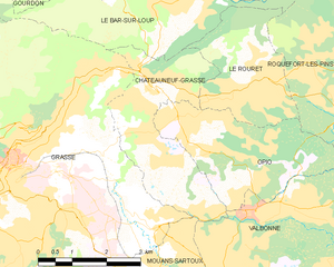
Ле-Руре (Le Rouret, Le Rouret)
- коммуна в департаменте Приморские Альпы, регион Прованс — Альпы — Лазурный Берег, Франция
 Hiking in Ле-Руре
Le Rouret is a charming village located in the Alpes-Maritimes department in southeastern France, near the French Riviera. Nestled in the hills, it offers beautiful landscapes and access to several hiking trails suitable for different skill levels.
Hiking Opportunities in Le Rouret:
-
Scenic Trails: The area is characterized by picturesque views of the countryside, olive groves, and wooded areas. Trails often lead through rolling hills, providing stunning panoramas of the region.
-
Nature Reserves: Nearby, you can find natural reserves, such as the Valmasque Park, where you can enjoy longer hikes that immerse you in local flora and fauna. These areas house diverse wildlife and plant species native to the region.
-
Proximity to Grasse: Le Rouret is close to Grasse, the perfume capital of the world. Many hiking routes offer combined experiences, where you can explore both nature and local heritage.
-
Trail Difficulty: Trails range from easy walks suitable for families to more challenging hikes for experienced trekkers. Be sure to check local maps and trail guides before setting out.
-
Local Climate: The Mediterranean climate means mild winters and warm summers, making it a year-round hiking destination. However, it’s best to hike in the spring or fall when temperatures are more comfortable.
Tips for Hiking in Le Rouret:
- Wear Proper Footwear: Good hiking shoes are essential due to varied terrain.
- Stay Hydrated: Carry sufficient water, especially during warmer months.
- Check the Weather: Local weather can change quickly, so be prepared for different conditions.
- Respect Nature: Follow Leave No Trace principles; pack out what you bring in, and stay on marked paths.
- Local Guidance: Consider hiring a local guide for an enriched experience, especially if you're unfamiliar with the area.
Conclusion:
Hiking in Le Rouret offers a unique blend of natural beauty and cultural experiences. Whether you're a beginner or an expert, you'll find trails that suit your preferences amidst the tranquility of this lovely French village.
- Страна:

- Почтовый код: 06650
- Координаты: 43° 40' 28" N, 7° 0' 20" E


- GPS треки (wikiloc): [Ссылка]
- Площадь: 7.1 кв.км
- Население: 4003
- Википедия русская: wiki(ru)
- Википедия английская: wiki(en)
- Википедия национальная: wiki(fr)
- Хранилище Wikidata: Wikidata: Q475850
- Катеория в википедии: [Ссылка]
- код Freebase: [/m/03m4z3j]
- код Freebase: [/m/03m4z3j]
- код GeoNames: Альт: [6455473]
- код GeoNames: Альт: [6455473]
- номер SIREN: [210601126]
- номер SIREN: [210601126]
- код VIAF: Альт: [233858501]
- код VIAF: Альт: [233858501]
- код тезауруса PACTOLS: [pcrtl55aheznqd]
- код тезауруса PACTOLS: [pcrtl55aheznqd]
- WOEID: [604474]
- WOEID: [604474]
- код муниципалитета INSEE: 06112
- код муниципалитета INSEE: 06112
Граничит с регионами:

Шатонёф-Грас
- коммуна в департаменте Приморские Альпы, регион Прованс — Альпы — Лазурный Берег, Франция
Hiking in Шатонёф-Грас
Châteauneuf-Grasse, located in the Alpes-Maritimes department of the Provence-Alpes-Côte d'Azur region in France, offers a picturesque backdrop for hiking enthusiasts. The area is characterized by its stunning landscapes, charming villages, and a mild Mediterranean climate, making it an ideal destination for outdoor activities....
- Страна:
- Почтовый код: 06740
- Координаты: 43° 40' 30" N, 6° 58' 30" E
- GPS треки (wikiloc): [Ссылка]
- Площадь: 8.95 кв.км
- Население: 3219
- Веб сайт: [Ссылка]

Рокфор-ле-Пен
- коммуна в департаменте Приморские Альпы, регион Прованс — Альпы — Лазурный Берег, Франция
Hiking in Рокфор-ле-Пен
Roquefort-les-Pins is a charming village located in the Alpes-Maritimes department in the Provence-Alpes-Côte d'Azur region of France. It offers a variety of hiking opportunities that allow you to explore the beautiful natural surroundings, including forests, hills, and stunning views of the French Riviera....
- Страна:
- Почтовый код: 06330
- Координаты: 43° 39' 56" N, 7° 3' 3" E
- GPS треки (wikiloc): [Ссылка]
- Высота над уровнем моря: 250 м m
- Площадь: 21.53 кв.км
- Население: 6628
- Веб сайт: [Ссылка]


Ле-Бар-сюр-Лу
- коммуна в департаменте Приморские Альпы, регион Прованс — Альпы — Лазурный Берег, Франция
Hiking in Ле-Бар-сюр-Лу
Le Bar-sur-Loup is a picturesque village in the Alpes-Maritimes region of France, nestled in the foothills of the French Alps. Known for its stunning scenery and proximity to nature, it offers several opportunities for hiking enthusiasts. Here are some key points to consider when planning a hike in and around Le Bar-sur-Loup:...
- Страна:
- Почтовый код: 06620
- Координаты: 43° 42' 5" N, 6° 59' 20" E
- GPS треки (wikiloc): [Ссылка]
- Высота над уровнем моря: 310 м m
- Площадь: 14.47 кв.км
- Население: 3014
- Веб сайт: [Ссылка]

Опьо
- коммуна в департаменте Приморские Альпы, регион Прованс — Альпы — Лазурный Берег, Франция
Hiking in Опьо
Hiking in Opio, located in the Alpes-Maritimes region of France, offers a wonderful mix of beautiful landscapes, charming villages, and moderate hiking trails suited for different skill levels....
- Страна:
- Почтовый код: 06650
- Координаты: 43° 40' 6" N, 6° 58' 54" E
- GPS треки (wikiloc): [Ссылка]
- Площадь: 9.47 кв.км
- Население: 2212