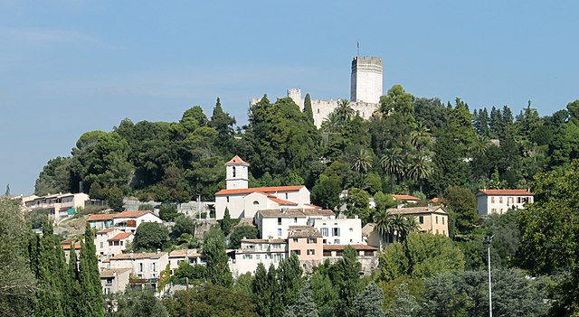
Рокфор-ле-Пен (Roquefort-les-Pins, Roquefort-les-Pins)
- коммуна в департаменте Приморские Альпы, регион Прованс — Альпы — Лазурный Берег, Франция
 Hiking in Рокфор-ле-Пен
Roquefort-les-Pins is a charming village located in the Alpes-Maritimes department in the Provence-Alpes-Côte d'Azur region of France. It offers a variety of hiking opportunities that allow you to explore the beautiful natural surroundings, including forests, hills, and stunning views of the French Riviera.
Popular Hiking Trails:
-
Chemin de la Manda: This scenic trail takes you through picturesque landscapes where you can enjoy the local flora and fauna. It’s suitable for various fitness levels and typically offers beautiful views of the surrounding hills.
-
Les Baous: The nearby hills known as Les Baous provide several hiking routes with varying difficulty. The Baou de Saint-Jeannet and Baou de la Gaude are popular destinations, offering panoramic views. The trails can range from easy walks to more challenging ascents.
-
Puy de Tourrettes: This is another excellent hiking spot that provides trails suitable for both casual walkers and more experienced hikers. The views from the top are remarkable, capturing the beauty of the Côte d'Azur.
Tips for Hiking in Roquefort-les-Pins:
-
Prepare for the Weather: The region can be quite warm in summer, so it’s essential to bring enough water and wear appropriate clothing. Spring and fall are ideal for hiking due to milder temperatures.
-
Footwear: Sturdy hiking shoes or boots are recommended, as some trails can be rocky or uneven.
-
Navigation: It’s useful to have a map or a GPS device, as not all trails may be well-marked. Consider downloading a hiking app for easier navigation.
-
Local Flora and Fauna: Keep an eye out for local wildlife and plant species. The region is known for its rich biodiversity.
-
Respect Nature: Always follow the principles of Leave No Trace—pack out what you bring in and stay on designated trails to protect the environment.
Local Amenities:
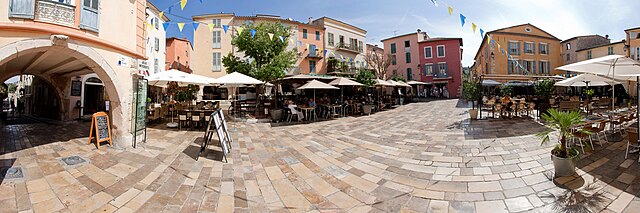
There are several cafes and restaurants in Roquefort-les-Pins where you can rest and enjoy local cuisine after a day of hiking. Additionally, it’s a good idea to check with local tourist information for maps and recommendations on the best trails.
Hiking in Roquefort-les-Pins provides an excellent way to appreciate the natural beauty of the region while enjoying the tranquility that comes with being surrounded by nature. Whether you're a seasoned hiker or a casual walker, you'll find paths to suit your preferences.
- Страна:

- Почтовый код: 06330
- Координаты: 43° 39' 56" N, 7° 3' 3" E


- GPS треки (wikiloc): [Ссылка]
- Высота над уровнем моря: 250 м m
- Площадь: 21.53 кв.км
- Население: 6628
- Веб сайт: http://www.mairie-roquefort-les-pins.fr/
- Википедия русская: wiki(ru)
- Википедия английская: wiki(en)
- Википедия национальная: wiki(fr)
- Хранилище Wikidata: Wikidata: Q381338
- Катеория в википедии: [Ссылка]
- код Freebase: [/m/02q4z6w]
- код Freebase: [/m/02q4z6w]
- код GeoNames: Альт: [6559500]
- код GeoNames: Альт: [6559500]
- номер SIREN: [210601050]
- номер SIREN: [210601050]
- код BNF: [13121161w]
- код BNF: [13121161w]
- код VIAF: Альт: [140715410]
- код VIAF: Альт: [140715410]
- код тезауруса PACTOLS: [pcrtx2Y7KrlE00]
- код тезауруса PACTOLS: [pcrtx2Y7KrlE00]
- код муниципалитета INSEE: 06105
- код муниципалитета INSEE: 06105
Граничит с регионами:

Вильнёв-Лубе
- коммуна в департаменте Приморские Альпы, регион Прованс — Альпы — Лазурный Берег, Франция
Hiking in Вильнёв-Лубе
Villeneuve-Loubet is a charming commune in the Alpes-Maritimes department in the Provence-Alpes-Côte d'Azur region of France. It's located between Nice and Antibes, which makes it an appealing base for hikers looking to explore both coastal and inland trails....
- Страна:
- Почтовый код: 06270
- Координаты: 43° 39' 29" N, 7° 7' 17" E
- GPS треки (wikiloc): [Ссылка]
- Площадь: 19.6 кв.км
- Население: 14266
- Веб сайт: [Ссылка]

Вальбонн
- коммуна в департаменте Приморские Альпы, регион Прованс — Альпы — Лазурный Берег, Франция
Hiking in Вальбонн
Valbonne, located in the Alpes-Maritimes department in the Provence-Alpes-Côte d'Azur region of France, is known for its picturesque ambiance and lush surroundings, making it a lovely destination for hiking enthusiasts....
- Страна:
- Почтовый код: 06560
- Координаты: 43° 38' 29" N, 7° 0' 32" E
- GPS треки (wikiloc): [Ссылка]
- Площадь: 18.97 кв.км
- Население: 13183


Турет-сюр-Лу
- коммуна в департаменте Приморские Альпы, регион Прованс — Альпы — Лазурный Берег, Франция
Hiking in Турет-сюр-Лу
Tourrettes-sur-Loup is a charming medieval village located in the French Riviera, known for its stunning views and picturesque scenery. The area offers a variety of hiking opportunities, catering to different skill levels. Here are some highlights for hiking in and around Tourrettes-sur-Loup:...
- Страна:
- Почтовый код: 06140
- Координаты: 43° 42' 58" N, 7° 3' 36" E
- GPS треки (wikiloc): [Ссылка]
- Площадь: 29.28 кв.км
- Население: 3995

Ле-Руре
- коммуна в департаменте Приморские Альпы, регион Прованс — Альпы — Лазурный Берег, Франция
Hiking in Ле-Руре
Le Rouret is a charming village located in the Alpes-Maritimes department in southeastern France, near the French Riviera. Nestled in the hills, it offers beautiful landscapes and access to several hiking trails suitable for different skill levels....
- Страна:
- Почтовый код: 06650
- Координаты: 43° 40' 28" N, 7° 0' 20" E
- GPS треки (wikiloc): [Ссылка]
- Площадь: 7.1 кв.км
- Население: 4003


Ле-Бар-сюр-Лу
- коммуна в департаменте Приморские Альпы, регион Прованс — Альпы — Лазурный Берег, Франция
Hiking in Ле-Бар-сюр-Лу
Le Bar-sur-Loup is a picturesque village in the Alpes-Maritimes region of France, nestled in the foothills of the French Alps. Known for its stunning scenery and proximity to nature, it offers several opportunities for hiking enthusiasts. Here are some key points to consider when planning a hike in and around Le Bar-sur-Loup:...
- Страна:
- Почтовый код: 06620
- Координаты: 43° 42' 5" N, 6° 59' 20" E
- GPS треки (wikiloc): [Ссылка]
- Высота над уровнем моря: 310 м m
- Площадь: 14.47 кв.км
- Население: 3014
- Веб сайт: [Ссылка]

Опьо
- коммуна в департаменте Приморские Альпы, регион Прованс — Альпы — Лазурный Берег, Франция
Hiking in Опьо
Hiking in Opio, located in the Alpes-Maritimes region of France, offers a wonderful mix of beautiful landscapes, charming villages, and moderate hiking trails suited for different skill levels....
- Страна:
- Почтовый код: 06650
- Координаты: 43° 40' 6" N, 6° 58' 54" E
- GPS треки (wikiloc): [Ссылка]
- Площадь: 9.47 кв.км
- Население: 2212


Ла-Коль-сюр-Лу
- коммуна в департаменте Приморские Альпы, регион Прованс — Альпы — Лазурный Берег, Франция
Hiking in Ла-Коль-сюр-Лу
La Colle-sur-Loup is a charming village located in the Provence-Alpes-Côte d'Azur region of France, near the picturesque French Riviera. The area is renowned for its stunning natural landscapes, making it an excellent spot for hiking enthusiasts. Here are some highlights of hiking in La Colle-sur-Loup:...
- Страна:
- Почтовый код: 06480
- Координаты: 43° 41' 11" N, 7° 6' 14" E
- GPS треки (wikiloc): [Ссылка]
- Площадь: 9.82 кв.км
- Население: 7895
- Веб сайт: [Ссылка]