Опьо (Opio, Opio)
- коммуна в департаменте Приморские Альпы, регион Прованс — Альпы — Лазурный Берег, Франция
 Hiking in Опьо
Hiking in Opio, located in the Alpes-Maritimes region of France, offers a wonderful mix of beautiful landscapes, charming villages, and moderate hiking trails suited for different skill levels.
Trails and Routes
-
Nearby Trails: While Opio itself may not have extensive trails, it's conveniently located near several well-known hiking areas such as the Pré-Alpes d'Azur Regional Natural Park. Here, you can find a variety of trails that range from easy walks to more challenging hikes.
-
Le Sentier des Ocres: A recommended hike in the nearby area is “Le Sentier des Ocres,” a trail that showcases stunning views of the ochre cliffs and the surrounding landscapes.
-
Villa Fragonard Circuit: This is a family-friendly loop that takes you through the charming countryside and citrus orchards around the region, offering a taste of local flora and scenery.
Scenery and Environment
The region boasts a Mediterranean climate, which means you'll experience mild winters and hot, dry summers. The terrain features a delightful mix of hills, forests, and farmland, allowing for picturesque views and a variety of ecosystems.
Tips for Hikers
- Best Time to Visit: Spring (April to June) and fall (September to October) are ideal times to hike, offering pleasant temperatures and blooming nature or autumnal colors.
- Gear: As with all hiking, proper footwear, hydration, and sun protection are essential. Make sure to also bring a map or download hiking apps that can provide trail information.
- Local Insights: Stop by local tourism offices for maps and advice on current trail conditions and recommendations for guided hikes.
Nearby Attractions
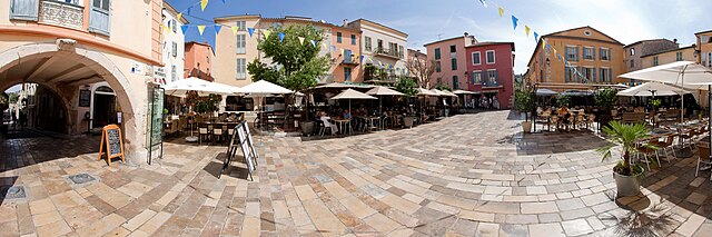
After your hike, you can explore the lovely village of Opio itself, known for its beautiful architecture, local artisans, and culinary delights. Additionally, the nearby towns of Grasse and Valbonne offer cultural experiences and are worth a visit.
Overall, hiking in and around Opio is a rewarding experience that combines physical activity with the chance to immerse yourself in the stunning landscapes and local culture of the French Riviera.
- Страна:

- Почтовый код: 06650
- Координаты: 43° 40' 6" N, 6° 58' 54" E


- GPS треки (wikiloc): [Ссылка]
- Площадь: 9.47 кв.км
- Население: 2212
- Википедия русская: wiki(ru)
- Википедия английская: wiki(en)
- Википедия национальная: wiki(fr)
- Хранилище Wikidata: Wikidata: Q850534
- Катеория в википедии: [Ссылка]
- код Freebase: [/m/02q4yjj]
- код Freebase: [/m/02q4yjj]
- код GeoNames: Альт: [6446723]
- код GeoNames: Альт: [6446723]
- номер SIREN: [210600896]
- номер SIREN: [210600896]
- код VIAF: Альт: [246269129]
- код VIAF: Альт: [246269129]
- код муниципалитета INSEE: 06089
- код муниципалитета INSEE: 06089
Граничит с регионами:

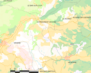
Шатонёф-Грас
- коммуна в департаменте Приморские Альпы, регион Прованс — Альпы — Лазурный Берег, Франция
Hiking in Шатонёф-Грас
Châteauneuf-Grasse, located in the Alpes-Maritimes department of the Provence-Alpes-Côte d'Azur region in France, offers a picturesque backdrop for hiking enthusiasts. The area is characterized by its stunning landscapes, charming villages, and a mild Mediterranean climate, making it an ideal destination for outdoor activities....
- Страна:
- Почтовый код: 06740
- Координаты: 43° 40' 30" N, 6° 58' 30" E
- GPS треки (wikiloc): [Ссылка]
- Площадь: 8.95 кв.км
- Население: 3219
- Веб сайт: [Ссылка]

Рокфор-ле-Пен
- коммуна в департаменте Приморские Альпы, регион Прованс — Альпы — Лазурный Берег, Франция
Hiking in Рокфор-ле-Пен
Roquefort-les-Pins is a charming village located in the Alpes-Maritimes department in the Provence-Alpes-Côte d'Azur region of France. It offers a variety of hiking opportunities that allow you to explore the beautiful natural surroundings, including forests, hills, and stunning views of the French Riviera....
- Страна:
- Почтовый код: 06330
- Координаты: 43° 39' 56" N, 7° 3' 3" E
- GPS треки (wikiloc): [Ссылка]
- Высота над уровнем моря: 250 м m
- Площадь: 21.53 кв.км
- Население: 6628
- Веб сайт: [Ссылка]

Вальбонн
- коммуна в департаменте Приморские Альпы, регион Прованс — Альпы — Лазурный Берег, Франция
Hiking in Вальбонн
Valbonne, located in the Alpes-Maritimes department in the Provence-Alpes-Côte d'Azur region of France, is known for its picturesque ambiance and lush surroundings, making it a lovely destination for hiking enthusiasts....
- Страна:
- Почтовый код: 06560
- Координаты: 43° 38' 29" N, 7° 0' 32" E
- GPS треки (wikiloc): [Ссылка]
- Площадь: 18.97 кв.км
- Население: 13183

Ле-Руре
- коммуна в департаменте Приморские Альпы, регион Прованс — Альпы — Лазурный Берег, Франция
Hiking in Ле-Руре
Le Rouret is a charming village located in the Alpes-Maritimes department in southeastern France, near the French Riviera. Nestled in the hills, it offers beautiful landscapes and access to several hiking trails suitable for different skill levels....
- Страна:
- Почтовый код: 06650
- Координаты: 43° 40' 28" N, 7° 0' 20" E
- GPS треки (wikiloc): [Ссылка]
- Площадь: 7.1 кв.км
- Население: 4003